Double Ditch

Last updated
Double Ditch State Historic Site
Double Ditch Aerial2.jpg
Aerial view of double ditch site
USA North Dakota location map.svg
Red pog.svg
Usa edcp location map.svg
Red pog.svg
Nearest city Bismarck, North Dakota
Coordinates 46°56′11″N100°54′03″W / 46.93639°N 100.90083°W / 46.93639; -100.90083 (Double Ditch Indian Village) Coordinates: 46°56′11″N100°54′03″W / 46.93639°N 100.90083°W / 46.93639; -100.90083 (Double Ditch Indian Village)
Area37.5 acres (15.2 ha)
NRHP reference No. 79001769 [1]
Added to NRHPJanuary 29, 1979

Double Ditch, also known as the Double Ditch State Historic Site, Burgois Site, 32BL8, Bourgois Site, and Double Ditch Earth Lodge Village Site, is an archaeological site located on the east bank of the Missouri River [2] north of Bismarck, North Dakota, United States. It is named for the two visible trenches that once served as fortifications for the village, but archaeologists found a further two ditches outside these indicating that the population was originally larger. [3]

Contents

Mound B excavation at Double Ditch Indian Village site, 1905 Mound B excavation at Double Ditch Indian Village site.jpg
Mound B excavation at Double Ditch Indian Village site, 1905

The site was the location of a Mandan Native American earth lodge village from approximately 1450A.D. [2] to 1785 A.D. It was abandoned after the 1775–1782 North American smallpox epidemic. [4] The site includes remains of earth lodges, midden mounds, and fortification ditches. It is managed by the State Historical Society of North Dakota.

The archeological site was listed on the National Register of Historic Places in 1979. Also at the location are Depression Era Work Relief Construction Features at Double Ditch Indian Village Site State Historic Site, which were separately listed on the National Register in 2014.

Overview

Earthlodge floor plan. This floorplan of a circular earthlodge shows the four post and beam central supports (the square in the center). The wall between the entry and the fireplace helped to prevent drafts from disturbing the fire or chilling the residents. Beds were arranged around the walls. Mandan Earthlodge Floor Plan.jpg
Earthlodge floor plan. This floorplan of a circular earthlodge shows the four post and beam central supports (the square in the center). The wall between the entry and the fireplace helped to prevent drafts from disturbing the fire or chilling the residents. Beds were arranged around the walls.

The Mandans built dome-shaped houses of logs and earth, known as earth-lodges. [5] The raised areas around the village are midden mounds or earthen mounds ranging from one to ten feet high. There are more than 30 mounds surrounding the village. Fortification systems consisted of a deep moat and a wall of wooden posts that formed a palisade. Natural features, such as steep terrain and riverbanks, also were used for added protection. [5]

Population decline

In 2002 Kenneth Kvamme generated digitally enhanced maps of Double Ditch using radio gradiometry techniques. The new survey methods revealed two more ditches, outside the two that were already known, extending the village well beyond its known boundaries. Investigators concluded that at the time of its founding, just before 1500, Double Ditch had a peak population of two thousand and an area of 19 acres. [3] In the mid-to late 1500s, a new trench—ditch 3— was built inside ditch 4. This was also soon abandoned and ditch 2, the outermost of the two ditches still visible constructed inside ditch 3. There was a 20 percent reduction in the area of the town by 1600. The loss of population may have been due to drought or infection. [2] In the mid 18th Century, the innermost (and still visible) fortification ditch was constructed, enclosing an area of four acres, indicating a population at that time of fewer than four hundred. [2] At that time, the entire surface layer of dirt in the village was laboriously scraped off, possibly after a horrific infection. [2]

Depression Era Work Relief Construction Features

Depression Era Work Relief Construction Features at Double Ditch Indian Village Site State Historic Site
DOUBLE DITCH EARTH LODGE VILLAGE SITE.jpg
Structures in 2007
USA North Dakota location map.svg
Red pog.svg
Usa edcp location map.svg
Red pog.svg
Location State Highway 1804, Burleigh County, North Dakota, near Bismarck
Area37.45 acres (15.16 ha) [6]
Built1930s???
Built byCCC?
Architectural style WPA Rustic
MPS Federal Relief Construction in North Dakota, 1931-1943, MPS
NRHP reference No. 14000896 [7]
Added to NRHPNovember 5, 2014 [7]

Depression Era Work Relief Construction Features at Double Ditch Indian Village Site State Historic Site was listed on the National Register in 2014. [7]

A building and walls built as Great Depression work-relief projects in 1930s???

The listing included one contributing building and eight contributing objects. These are in WPA Rustic style. [6]

The property is owned by the State Historical Society of North Dakota. [6]

[8]

[9]

See also

Related Research Articles

<span class="mw-page-title-main">Crow Creek massacre</span> United States historic place

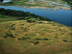
The Crow Creek massacre occurred around the mid-14th century AD between Native American groups at a site along the upper Missouri River in the South Dakota area; it is now within the Crow Creek Indian Reservation. Crow Creek Site, the site of the massacre near Chamberlain, is an archaeological site and a U.S. National Historic Landmark, located at coordinates 43°58′48″N 99°19′54″W. An excavation of part of the site was done in the 1950s, at the time of dam construction on the river. Additional excavations were conducted in 1978 and later.

<span class="mw-page-title-main">Mandan</span> Native American tribe of the Great Plains

The Mandan are a Native American tribe of the Great Plains who have lived for centuries primarily in what is now North Dakota. They are enrolled in the Three Affiliated Tribes of the Fort Berthold Reservation. About half of the Mandan still reside in the area of the reservation; the rest reside around the United States and in Canada.

<span class="mw-page-title-main">Fort Abraham Lincoln</span> North Dakota state park

Fort Abraham Lincoln State Park is a North Dakota state park located 7 miles (11 km) south of Mandan, North Dakota, United States. The park is home to the replica Mandan On-A-Slant Indian Village and reconstructed military buildings including the Custer House.

<span class="mw-page-title-main">Knife River Indian Villages National Historic Site</span> National Historic Site of the United States in North Dakota

The Knife River Indian Villages National Historic Site, which was established in 1974, preserves the historic and archaeological remnants of bands of Hidatsa, Northern Plains Indians, in North Dakota. This area was a major trading and agricultural area. Three villages were known to occupy the Knife area. In general, these three villages are known as Hidatsa villages. Broken down, the individual villages are Awatixa Xi'e, Awatixa and Big Hidatsa village. Awatixa Xi'e is believed to be the oldest village of the three. The Big Hidatsa village was established around 1600.

<span class="mw-page-title-main">Earth lodge</span> Semi-subterranean building

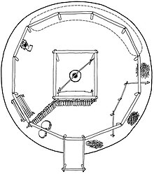
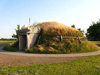
An earth lodge is a semi-subterranean building covered partially or completely with earth, best known from the Native American cultures of the Great Plains and Eastern Woodlands. Most earth lodges are circular in construction with a dome-like roof, often with a central or slightly offset smoke hole at the apex of the dome. Earth lodges are well-known from the more-sedentary tribes of the Plains such as the Hidatsa, Mandan, and Arikara, but they have also been identified archaeologically among sites of the Mississippian culture in the eastern United States.

<span class="mw-page-title-main">Town Creek Indian Mound</span> National Historic Landmark in North Carolina

Town Creek Indian Mound is a prehistoric Native American archaeological site located near present-day Mount Gilead, Montgomery County, North Carolina, in the United States. The site, whose main features are a platform mound with a surrounding village and wooden defensive palisade, was built by the Pee Dee, a South Appalachian Mississippian culture people that developed in the region as early as 980 CE. They thrived in the Pee Dee River region of North and South Carolina during the Pre-Columbian era. The Town Creek site was an important ceremonial site occupied from about 1150—1400 CE. It was abandoned for unknown reasons. It is the only ceremonial mound and village center of the Pee Dee located within North Carolina.

<span class="mw-page-title-main">Fort Clark Trading Post State Historic Site</span> State historic site of North Dakota, United States

Fort Clark Trading Post State Historic Site was once the home to a Mandan and later an Arikara settlement. Over the course of its history it also had two factories. Today only archeological remains survive at the site located eight miles west of Washburn, North Dakota, United States.

The Phipps Site (13CK21) is a Late Prehistoric Mill Creek culture archaeological site near Cherokee in Cherokee County, Iowa, United States. Its principal feature, a refuse midden, has yielded important information on the formation of middens in the region. The site was declared a National Historic Landmark in 1964.

<span class="mw-page-title-main">Big Hidatsa Village Site</span> Archaeological site in North Dakota, United States

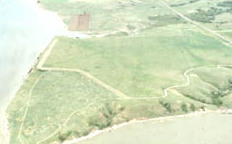
The Big Hidatsa site, occupied between ca. 1740 and 1850, is an earthlodge located in the 1,758 acre Knife River Indian Villages National Historic Site in North Dakota, United States. This National Historic Site was established in 1974 “to focus on the cultures and lifestyles of the Plains Indians”.

<span class="mw-page-title-main">Menoken Indian Village Site</span> United States historic place

The Menoken Indian Village Site, also known as Menoken Site, Verendrye Site or Apple Creek Site is an archeological site near Bismarck, North Dakota. The site, that of a fortified village occupied c. 1300, is important in the region's prehistory, as it is one of the only sites that predates sites that are more clearly associated with the historic Hidatsa, Mandan, and Arikara cultures. It was declared a National Historic Landmark in 1964, and was listed on the National Register of Historic Places in 1966. It is located on 171st Street NE, north of Menoken, about 10 miles (16 km) east of Bismarck. The site managed by the state as the Menoken Indian Village State Historic Site, and is open to the public.

<span class="mw-page-title-main">Huff Archeological Site</span> United States historic place

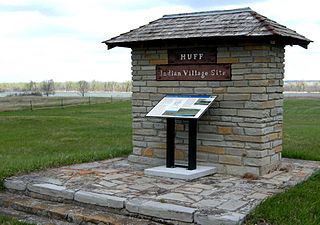
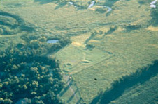
The Huff Archeological Site is a prehistoric Mandan village in North Dakota dated around 1450 AD. It was discovered in the early 1900s. The site has been designated a National Historic Landmark, and is one of the best preserved sites of the period.

<span class="mw-page-title-main">Arzberger site</span> United States historic place

The Arzberger site, designated by archaeologists with the Smithsonian trinomial 39HU6, is a major archaeological site in Hughes County, near Pierre, South Dakota. It was declared a National Historic Landmark in 1964. It is a large fortified village, that is the type site for the Initial Coalescent, a culture that flourished in the area c. 1200-1350 CE.

<span class="mw-page-title-main">Bloom Site</span> United States historic place

The Bloom Site, designated by the Smithsonian trinomial 39HS1, is an archaeological site in Hanson County, South Dakota. It was declared a National Historic Landmark in 1964.

<span class="mw-page-title-main">Mitchell Site</span> United States historic place

The Mitchell Site, designated by the Smithsonian trinomial 39DV2, is an important archaeological site in Mitchell, Davison County, South Dakota. It was declared a National Historic Landmark in 1964. At that time it was the only reliably dated site of the Lower James River Phase. The site, sheltered under a dome, is managed by a nonprofit organization and is open to the public as Mitchell Prehistoric Indian Village. Visitors can watch archaeologists uncover artifacts in the Thomsen Center Archeodome. The Boehnen Memorial Museum features a reconstructed lodge and many of the artifacts found at the site.

Fort Center is an archaeological site in Glades County, Florida, United States, a few miles northwest of Lake Okeechobee. It was occupied for more than 2,000 years, from 450 BCE until about 1700 CE. The inhabitants of Fort Center may have been cultivating maize centuries before it appeared anywhere else in Florida.

<span class="mw-page-title-main">Frogmore Mound Site</span> United States historic place

Frogmore Mound Site is an archaeological site of the Late Coles Creek culture in Concordia Parish, Louisiana. The site is located 7 miles (11 km) west of Ferriday on US 84. It was added to the National Register of Historic Places on July 28, 2004.

The Lamar mounds and village site (9BI2) is an important archaeological site on the banks of the Ocmulgee River in Bibb County, Georgia, several miles to the southeast of the Ocmulgee mound site. Both mound sites are part of the Ocmulgee Mounds National Historical Park, a national park and historic district created in 1936 and run by the U.S. National Park Service. Historians and archaeologists have theorized that the site is the location of the main village of the Ichisi encountered by the Hernando de Soto expedition in 1539.

The Biesterfeldt Site is an archaeological site near Lisbon, North Dakota, United States, located along the Sheyenne River. The site is the only documented village of earth lodges in the watershed of the Red River, and the only one that has been unambiguously affiliated with the Cheyenne tribe. An independent group of Cheyennes is believed to have occupied it c. 1724-1780. In 1980, the site was listed on the National Register of Historic Places because of its archaeological significance. It was designated a National Historic Landmark in 2016.

<span class="mw-page-title-main">Chief Looking's Village site (32BL3)</span> United States historic place

The Chief Looking's Village site (32BL3) is a historic archeological site on the east side of Pioneer Park in Bismarck, North Dakota that was listed on the National Register of Historic Places in 1978. It has also been known as Ward Earth Lodge Village. It was listed on the National Register of Historic Places in 1978.

References

  1. "National Register Information System". National Register of Historic Places . National Park Service. July 9, 2010.
  2. 1 2 3 4 5 Elizabeth Fenn: Encounters at the Heart of the World: a History of the Mandan People
  3. 1 2 Kvamme, Kenneth L. "Archaeological prospecting at the Double Ditch State Historic Site, North Dakota, USA". Archaeological Prospection. 15: 62–79. doi:10.1002/arp.325.
  4. "Double Ditch Indian Village". State Historical Society of North Dakota. Retrieved August 7, 2012.
  5. 1 2 "Double Ditch Indian Village - History - State Historical Society of North Dakota". history.nd.gov. Retrieved 2016-01-08.
  6. 1 2 3 Lorna Meidinger (July 2014). National Register of Historic Places Registration: Depression Era Work Relief Construction Features at Double Ditch Indian Village Site State Historic Site / 32BL8, Double Ditch arth Lodge Village Site . Retrieved October 7, 2022. Includes aerial and historic photos, and 12 photos from 2014.
  7. 1 2 3 "Weekly listings" (PDF). National Park Service.
  8. "Double Ditch State Recreation Area". Oh Ranger.com.
  9. Steve C. Martens (August 28, 2010). National Register of Historic Places Multiple Property Documentation: Federal Relief Construction in North Dakota, 1931-1943, MPS. NARA. Includes 44 photos from 2009-2010. Downloading may be slow.

Commons-logo.svg Media related to Double Ditch State Historic Site at Wikimedia Commons