Menoken Indian Village Site

Last updated

Menoken Indian Village Site
Menoken Indian Village Site.jpg
Aerial view of the site
USA North Dakota location map.svg
Red pog.svg
Usa edcp location map.svg
Red pog.svg
Nearest city Bismarck, North Dakota
Coordinates 46°50′28″N100°31′06″W / 46.8412°N 100.5182°W / 46.8412; -100.5182
NRHP reference No. 66000599
Significant dates
Added to NRHPOctober 15, 1966 [1]
Designated NHLJuly 19, 1964 [2]

The Menoken Indian Village Site, also known as Menoken Site, Verendrye Site or Apple Creek Site is an archeological site near Bismarck, North Dakota. The site, that of a fortified village occupied c. 1300, is important in the region's prehistory, as it is one of the only sites that predates sites that are more clearly associated with the historic Hidatsa, Mandan, and Arikara cultures. It was declared a National Historic Landmark in 1964, [2] and was listed on the National Register of Historic Places in 1966. [1] It is located on 171st Street NE, north of Menoken, about 10 miles (16 km) east of Bismarck. The site managed by the state as the Menoken Indian Village State Historic Site, and is open to the public.

Contents

Also listed on the National Register, in 2010, is a set of Depression Era Work Relief Construction Features at Menoken State Historic Site.

Description

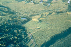
The Menoken Site occupies a terrace on the south side of Apple Creek, a tributary of the Missouri River, to which it flows near Bismarck. The site consists of a defensive earthworks, whose major component is a ditch about 245 metres (804 ft) in length, with four bastion loops projecting outward at equally spaced intervals. The ditch is about 1.5 metres (4.9 ft) deep, and varies in width from 6 to 7 metres (20 to 23 ft) in width. The ditch forms a curve, covering about 100° of a circle, and protects an inner area of about 1.5 acres (0.61 ha). Archaeological evidence indicates that there was originally a palisade just inside the ditch; only post holes of this structure survive. The inner area of the fortification, which has not been fully investigated, is estimated to have had between 11 and 13 semi-subterranean residential structures in it. [3]

This site, first excavated in the 1930s, was thought for many years to be that of a Mandan village visited by the French explorer La Verendrye, but archaeological investigations in the 1990s and early 2000s have revealed evidence that the site is actually somewhat older, and that the site was probably occupied by ancestors of one of the region's major tribal groups, with an occupation period c. 1100-1300. It was probably used as a semi-permanent settlement, from which the occupants would hunt bison and other wildlife. Extensive finds exist here of stone tools, predominantly quarried in the Lynch Quarry vicinity to the west, as well as ceramic pottery fragments and bone tools. [3]

The site was designated a National Historic Landmark in 1964, primarily on the basis of the belief (now known to be incorrect) that it was associated with La Verendrye, but it retains significance to its critical place in the region's prehistoric chronology, and its archaeological importance. [4] Elements of the site's improvements, made during the Great Depression, were listed on the National Register of Historic Places in 2010. The site, acquired by the state in 1937, is open to the public, with a walking trail that has interpretive signage.

Depression Era Work Relief Construction Features

Depression Era Work Relief Construction Features at Menoken State Historic Site
MenokenSite Kiosk.jpg
CCC kiosk, in 2017
Location171st St and 32nd Ave NE, Burleigh County, North Dakota (1.7 mi N of Menoken, near Bismarck)
Coordinates 46°50′28″N100°31′06″W / 46.8412°N 100.5182°W / 46.8412; -100.5182
Area1.9 acre portion of 13.7 acre parcel
Built1930s????
Built by Works Progress Administration
ArchitectRussell Reid
MPS Federal Relief Construction in North Dakota, 1931-1943, MPS
NRHP reference No. 10000998 [5]
Added to NRHPDecember 7, 2010 [5]

Depression Era Work Relief Construction Features at Menoken State Historic Site was listed on the National Register in 2010. [5] The listing included one contributing building and two contributing objects on a 1.9 acres (0.77 ha) portion of a 13.7 acres (5.5 ha) parcel. [6]

171st Street and 32nd Avenue NE; Bismarck vicinity 1.7 miles north of Menoken and 1 mile east from the I-94 exit at milepost 170

Late 19th & Early 20th Century Revivals / Late Gothic Revival / Picturesque. WPA Rustic

Work of the Works Progress Administration, with design directed by Russell Reid, Superintendent State Park Section. State Historical Society of North Dakota

historically Verendrye State Park

[7]

See also

Related Research Articles

<span class="mw-page-title-main">Crow Creek massacre</span> United States historic place

The Crow Creek massacre occurred around the mid-14th century AD and involved Native American groups at a site along the upper Missouri River in the South Dakota area; it is now within the Crow Creek Indian Reservation. Crow Creek Site, the site of the massacre near Chamberlain, is an archaeological site and a U.S. National Historic Landmark, located at coordinates 43°58′48″N 99°19′54″W. An excavation of part of the site was done in the 1950s, at the time of dam construction on the river. Additional excavations were conducted in 1978 and later.

<span class="mw-page-title-main">Mandan</span> Native American tribe of the Great Plains

The Mandan are a Native American tribe of the Great Plains who have lived for centuries primarily in what is now North Dakota. They are enrolled in the Three Affiliated Tribes of the Fort Berthold Reservation. About half of the Mandan still reside in the area of the reservation; the rest reside around the United States and in Canada.

<span class="mw-page-title-main">Fort Abraham Lincoln</span> North Dakota state park

Fort Abraham Lincoln State Park is a North Dakota state park located 7 miles (11 km) south of Mandan, North Dakota, United States. The park is home to the replica Mandan On-A-Slant Indian Village and reconstructed military buildings including the Custer House.

<span class="mw-page-title-main">Knife River Indian Villages National Historic Site</span> National Historic Site of the United States in North Dakota

The Knife River Indian Villages National Historic Site, which was established in 1974, preserves the historic and archaeological remnants of bands of Hidatsa, Northern Plains Indians, in North Dakota. This area was a major trading and agricultural area. Three villages were known to occupy the Knife area. In general, these three villages are known as Hidatsa villages. Broken down, the individual villages are Awatixa Xi'e, Awatixa and Big Hidatsa village. Awatixa Xi'e is believed to be the oldest village of the three. The Big Hidatsa village was established around 1600.

<span class="mw-page-title-main">National Register of Historic Places listings in North Dakota</span>

There are 461 properties and historic districts listed on the National Register of Historic Places in North Dakota. There are listings in 52 of North Dakota's 53 counties.

<span class="mw-page-title-main">Fort Clark Trading Post State Historic Site</span> State historic site of North Dakota, United States

Fort Clark Trading Post State Historic Site was once the home to a Mandan and later an Arikara settlement. Over the course of its history it also had two factories. Today only archeological remains survive at the site located eight miles west of Washburn, North Dakota, United States.

<span class="mw-page-title-main">Big Hidatsa Village Site</span> Archaeological site in North Dakota, United States

The Big Hidatsa site, occupied between ca. 1740 and 1850, is an earthlodge located in the 1,758 acre Knife River Indian Villages National Historic Site in North Dakota, United States. This National Historic Site was established in 1974 “to focus on the cultures and lifestyles of the Plains Indians”.

<span class="mw-page-title-main">Huff Archeological Site</span> United States historic place

The Huff Archeological Site is a prehistoric Mandan village in North Dakota dated around 1450 AD. It was discovered in the early 1900s. The site has been designated a National Historic Landmark, and is one of the best preserved sites of the period.

<span class="mw-page-title-main">Verendrye Site</span> United States historic place

The Verendrye Site is an historical archaeological site off Verendrye Drive in Fort Pierre, Stanley County, South Dakota, United States. Now a small public park, it is the place where the La Vérendrye brothers, the first known Europeans to explore this area, placed a lead plate bearing the crest of France, to claim the territory for their homeland, during their 1742-43 expedition to the Rocky Mountains.

<span class="mw-page-title-main">Bloom Site</span> United States historic place

The Bloom Site, designated by the Smithsonian trinomial 39HS1, is an archaeological site in Hanson County, South Dakota. It was declared a National Historic Landmark in 1964.

<span class="mw-page-title-main">Mitchell Site</span> United States historic place

The Mitchell Site, designated by the Smithsonian trinomial 39DV2, is an important archaeological site in Mitchell, Davison County, South Dakota. It was declared a National Historic Landmark in 1964. At that time it was the only reliably dated site of the Lower James River Phase. The site, sheltered under a dome, is managed by a nonprofit organization and is open to the public as Mitchell Prehistoric Indian Village. Visitors can watch archaeologists uncover artifacts in the Thomsen Center Archeodome. The Boehnen Memorial Museum features a reconstructed lodge and many of the artifacts found at the site.

<span class="mw-page-title-main">National Register of Historic Places listings in Burleigh County, North Dakota</span>

This is a list of the National Register of Historic Places listings in Burleigh County, North Dakota.

<span class="mw-page-title-main">Double Ditch</span> United States historic place

Double Ditch, also known as the Double Ditch State Historic Site, Burgois Site, 32BL8, Bourgois Site, and Double Ditch Earth Lodge Village Site, is an archaeological site located on the east bank of the Missouri River north of Bismarck, North Dakota, United States. It is named for the two visible trenches that once served as fortifications for the village, but archaeologists found a further two ditches outside these indicating that the population was originally larger.

<span class="mw-page-title-main">Liberty Memorial Bridge</span> United States historic place

The Liberty Memorial Bridge, across the Missouri River connecting the "twin cities" of Bismarck and Mandan, North Dakota, also known as Missouri River Bridge, was a Warren-Turner through truss structure that was built in 1920. It was listed on the National Register of Historic Places in 1997. It was replaced by a new bridge in 2008 and removed from the National Register in 2009.

The Biesterfeldt Site is an archaeological site near Lisbon, North Dakota, United States, located along the Sheyenne River. The site is the only documented village of earth lodges in the watershed of the Red River, and the only one that has been unambiguously affiliated with the Cheyenne tribe. An independent group of Cheyennes is believed to have occupied it c. 1724–1780. In 1980, the site was listed on the National Register of Historic Places because of its archaeological significance. It was designated a National Historic Landmark in 2016.

<span class="mw-page-title-main">Lynch Quarry site</span> United States historic place

The Lynch Quarry site, also known as the Lynch Knife River Flint Quarry, and designated by the Smithsonian trinomial 32DU526, is a historic pre-Columbian flint quarry located near Dunn Center, North Dakota, United States. The site was a major source of flint found at archaeological sites across North America, and it has been estimated that the material was mined there from 11,000 B.C. to A.D. 1600. The site was designated a National Historic Landmark in 2011.

<span class="mw-page-title-main">Arthur W. Van Horn</span> American architect

Arthur Wesley Van Horn was a prolific architect of Bismarck, North Dakota. A number of Van Horn's works, alone or as part of his firm, are listed on the U.S. National Register of Historic Places.

<span class="mw-page-title-main">Chief Looking's Village site (32BL3)</span> United States historic place

The Chief Looking's Village site (32BL3) is a historic archeological site on the east side of Pioneer Park in Bismarck, North Dakota that was listed in the National Register of Historic Places in 1978. It has also been known as Ward Earth Lodge Village. It was listed on the National Register of Historic Places in 1978.

References

  1. 1 2 "National Register Information System". National Register of Historic Places . National Park Service. January 23, 2007.
  2. 1 2 "Menoken Indian Village Site". National Historic Landmark summary listing. National Park Service. Archived from the original on March 22, 2005. Retrieved January 4, 2008.
  3. 1 2 "NHL nomination for Menoken Indian Village Site, Section 7" (PDF). National Park Service. Retrieved November 9, 2015.
  4. "Exceptional Places 2008" (PDF). National Park Service. Retrieved November 9, 2015.
  5. 1 2 3 "National Register of Historic Places 2010 Weekly Lists" (PDF). National Park Service . Retrieved October 7, 2022.
  6. Steve C. Martens (June 2010). National Register of Historic Places Registration: Depression Era Work Relief Construction Features at Menoken State Historic Site / Menoken Indian Village National Historic Landmark:(SITS 32 BL2); historically Verendrye State Park. NARA . Retrieved October 7, 2022.
  7. Steve C. Martens (August 28, 2010). National Register of Historic Places Multiple Property Documentation: Federal Relief Construction in North Dakota, 1931-1943, MPS. NARA. Includes 44 photos from 2009-2010, including of two Menoken structures on PDF pages 199-202. Downloading may be slow.