Pettigrew State Park is a North Carolina State Park in Tyrrell and Washington Counties, North Carolina in the United States. It covers 5,951 acres (24.08 km2) around the shore lines of Lake Phelps and the Scuppernong River. The park's developed facilities are south of U.S. Route 64 near Roper and Creswell, North Carolina. Pettigrew State Park is open for year-round recreation, including hiking, camping, fishing, boating and picnicking.

The Ocmulgee River is a western tributary of the Altamaha River, approximately 255 mi (410 km) long, in the U.S. state of Georgia. It is the westernmost major tributary of the Altamaha.
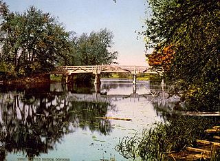
The Concord River is a 16.3-mile-long (26.2 km) tributary of the Merrimack River in eastern Massachusetts in the United States. The river drains a small rural and suburban region northwest of Boston. One of the most famous small rivers in U.S. history, it was the scene of an important early battle of the American Revolutionary War and was the subject of a famous 19th-century book by Henry David Thoreau.
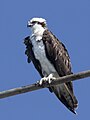
The alewife is an anadromous species of herring found in North America. It is one of the "typical" North American shads, attributed to the subgenus Pomolobus of the genus Alosa. As an adult it is a marine species found in the northern West Atlantic Ocean, moving into estuaries before swimming upstream to breed in freshwater habitats, but some populations live entirely in fresh water. It is best known for its invasion of the Great Lakes by using the Welland Canal to bypass Niagara Falls. Here, its population surged, peaking between the 1950s and 1980s to the detriment of many native species of fish. In an effort to control them biologically, Pacific salmon were introduced, only partially successfully. As a marine fish, the alewife is a US National Marine Fisheries Service "Species of Concern".

Belleisle Bay is a fjord-like branch of the Saint John River in the Canadian province of New Brunswick

Edwards Run is a 7.9-mile-long (12.7 km) tributary stream of the Cacapon River, belonging to the Potomac River and Chesapeake Bay watersheds. The stream is located in Hampshire County in the U.S. state of West Virginia's Eastern Panhandle. Edwards Run is named for Joseph Edwards and his family, whose plantation encompassed most of the stream's course. George Washington surveyed his property in the late 1740s. It is a major source of various species of elodea.
The Satucket River is 5.5-mile-long (8.9 km) river in southeastern Massachusetts within the Taunton River Watershed. It flows generally west from Robbins Pond in East Bridgewater, and into the Matfield River.
Sheldon Lake is a reservoir on Carpenters Bayou in the San Jacinto River basin, 16 miles (26 km) northeast of downtown Houston, Texas. The reservoir was created in 1943 when the federal government built a dam to provide fresh water for shipbuilding and shipping industries on the Houston Ship Channel during World War II. After the war, management of the reservoir was assumed by the City of Houston. In 1952, after the construction of the dam that creates Lake Houston, the city sold the reservoir to the Texas Parks and Wildlife Department for use as a waterfowl sanctuary and public fishing site. In 1984, land around the reservoir was designated the Sheldon State Wildlife Management Area.

The Blackwater River of southeastern Virginia flows from its source near the city of Petersburg, Virginia for about 105 miles (170 km) through the Inner Coastal Plain region of Virginia. The Blackwater joins the Nottoway River to form the Chowan River, which empties into Albemarle Sound. The Blackwater-Nottoway confluence forms the boundary between Virginia and North Carolina.

The Wacissa River is a large, spring-fed stream located in south-central Jefferson County, Florida. Its headwaters are located about a mile south of the town of Wacissa, where the river emerges crystal clear from a group of large limestone springs. From its headsprings, the river flows approximately 12 miles (19 km) south through a broad cypress swamp before breaking into numerous braided channels which join the Aucilla River a few miles further south. The river is managed by the Florida Fish & Wildlife Conservation Commission as part of the Aucilla Wildlife Management Area, and has been declared an Outstanding Florida Waterway by the Florida Department of Environmental Protection.

The life zones of West Virginia allow for a diversity of habitats for fauna, varying from large lowland farming valleys bordered with forest and meadow to highland ridge flats and heavy forestland, some with rocky ridge-line peaks. The "Mountain State" harbors at least 56 species and subspecies of mammals. The state has more than 300 types of birds and more than 100 species of fish.
Spednic Lake is a mesotrophic lake in the Chiputneticook Lakes chain along the Canada–United States border between the state of Maine and the province of New Brunswick that is best known for its bass fishing. Sometimes it is viewed as the headwaters of the St. Croix River, sometimes a lake further up the chain is considered the headwaters. The international border runs through the lake. A northeastern arm of the lake, located entirely in Canada, retains the name Palfrey Lake. Prior to dam construction that expanded Spednic Lake they were separate lakes, but now they are hydrologically and ecologically a single combined lake.

The Medomak River, historically known as the Muscongus River, is a 40-mile-long (64 km) river in Maine. From its source in Liberty, the river winds 32 miles (51 km) south to the head of its tidal river estuary in Waldoboro, then about 8 miles (13 km) south to Bremen. The river flows through Hockomock Channel into the head of Muscongus Bay. Medomak is Abenaki for "place (river) of many alewives".

The blueback herring or blueback shad is an anadromous species of herring from the east coast of North America, with a range from Nova Scotia to Florida. Blueback herring form schools and are believed to migrate offshore to overwinter near the bottom.

The natural environment of Virginia encompasses the physical geography and biology of the U.S. state of Virginia. Virginia has a total area of 42,774.2 square miles (110,784.67 km2), including 3,180.13 square miles (8,236.5 km2) of water, making it the 35th-largest state by area. Forests cover 65% of the state, wetlands and water cover 6% of the land in the state, while 5% of the state is a mixture of commercial, residential, and transitional.


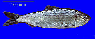
 Alewife herring
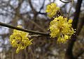
 Pumpkin ash ( Fraxinus profunda )