
Charlottenborg Palace is a large town mansion located on the corner of Kongens Nytorv and Nyhavn in Copenhagen, Denmark. Originally built as a residence for Ulrik Frederik Gyldenløve, it has served as the base of the Royal Danish Academy of Fine Arts since its foundation in 1754. Today it also houses Kunsthal Charlottenborg, an institution for contemporary art, and Danmarks Kunstbibliotek, the Royal Art Library.

Sankt Annæ Plads is a public square which marks the border between the Nyhavn area and Frederiksstaden neighborhoods of central Copenhagen, Denmark. It is a long narrow rectangle which extends inland from the waterfront, at a point just north of the Royal Danish Playhouse at the base of the Kvæsthus Pier, now known as Ofelia Plads, until it meets Bredgade. A major renovation of the square was completed in 2016.The Garrison Church is located on the south side of the square. Amaliegade, one of the two axes on which Frederiksstaden is centered, extends from the square.

Gothersgade is a major street in the City Centre of Copenhagen, Denmark. It extends from Kongens Nytorv to Sortedam Lake, passing Rosenborg Castle and Gardens, Nørreport Station and Copenhagen Botanic Gardens on the way.

Borgergade is a street in central Copenhagen, Denmark. It runs from Gothersgade to Store Kongensgade. As one of relatively few streets in central Copenhagen, the street, in its western part, is dominated by modern buildings. The eastern part passes through the Nyboder district.

Dronningegården is a Modernist residential complex in central Copenhagen, Denmark, consisting of four L-shaped buildings defining an urban space around the intersection of Adelgade and Dronningens Tværgade. Designed by Kay Fisker in collaboration with C. F. Møller and Svenn Eske Kristensen, it was built between 1943 and 1958, during the transition from Traditionalism to Modernism, as a notable example of Nordic Functionalism.

Gammel Mønt is a street in central Copenhagen, Denmark, located one block west of Gothersgade and Rosenborg Castle Garden.

The Moltke's Mansion is a town mansion on the corner of Bredgade and Dronningens Tværgade in Copenhagen, Denmark. It is one of several town mansions in Frederiksstaden, although it actually predates the neighbourhood by half a century. It was built for Ulrik Frederik Gyldenløve between 1700 and 1702 and was originally known as Gyldenløve's Little Mansion. It received its current name in 1842, after it was acquired by Adam Wilhelm Moltke, the first Danish Prime Minister under the Danish constitutional monarchy.
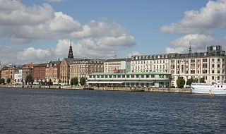
Havnegade is a waterfront promenade in central Copenhagen, Denmark, which runs between Knippelsbro and the mouth of the Nyhavn canal. Most of the street is lined with buildings from the 1860s and 1870s that were constructed as part of the redevelopment of the Gammelholm naval dockyards. It is the only place along Copenhagen's main harbourfront where residential buildings of that age face the water, although older warehouses and other industrial buildings elsewhere have been converted into residential use. The Modernist Bank of Denmark building is located at the western end of the street.
Ved Stranden is a canal side public space and street which runs along a short section of the Zealand side of Slotsholmen Canal in central Copenhagen, Denmark. It begins at Holmens Kanal, opposite the Church of Holmen, and runs west along the canal for one and a half blocks before widening into a small, triangular space adjacent to Højbro Bridge and Højbro Plads. The name of the street refers to Gammel Strand, 'Old Beach', which it formed part of until 1961.

Sølvgade is a street in central Copenhagen, Denmark, extending north-west from Borgergade to The Lakes where Fredens Bro connects it to Fredensgade. The section from Kronprinsessegade to Øster Voldgade follows the walled north-eastern margin of Rosenborg Castle Garden and the next section, from Øster Voldgade to the intersection with Farimagsgade, named Sølvtorvet although it is little more than a busy street junction, separates Copenhagen Botanical Garden from Østre Anlæg.

Store Kongensgade is the longest street in central Copenhagen, Denmark. It extends northeast from Kongens Nytorv to Esplanaden, running parallel to Bredgade, where it breaks left, continuing northwest to Grønningen.

Adelgade is a street in central Copenhagen, Denmark. It runs from Gothersgade in the south to Sankt Pauls Plads with St. Paul's Church in the north. The first half of the street is dominated by modern buildings while its last section passes through the Nyboder district.

Rigensgade is a street in central Copenhagen, Denmark. It links Sølvgade in the west with Øster Voldgade in the east. An underpass for pedestrians link the beginning of the street with Rosenborg Castle Gardens on the other side of Sølvgade. Notable buildings include the former Garrison Hospital. and the Methodist Jerusalem's Church.

The De Coninck House is a historic property located at Store Kongensgade 72 in central Copenhagen, Denmark. It takes its name after Frédéric de Coninck for whom it was built in the 1790s.
The Danneskiold-Laurvig Mansion is a historic building situated at Store Kongensgade 68 in central Copenhagen, Denmark. It was built in association with the Moltke's Mansion in Bredgade on the other side of the block.

Palægaragerne is an early Modernist parking facility and filling station located in a narrow courtyard at Dronningens Tværgade 4 in central Copenhagen, Denmark. It was built in the early 1930s and was the first multi-storey parking facility in Denmark. It takes its name after the neighboring Moltke Mansion. The parking facility and the canopy over the filling station were listed on the Danish registry of protected buildings and places by the Danish Heritage Agency on 13 July 1994. It is now owned by the property company Jeudan.
Fredericiagade is a street in central Copenhagen, Denmark. It runs from Amaliegade in the south to Rigensgade in the north.

Dronningens Tværgade 7 is a Neoclassical property situated opposite Moltke's Mansion in central Copenhagen, Denmark. The building was from 1824 to 1867 home to the Royal Art Museum, a precursor of the National Museum. The wine dealer Otto Suenson & Co. was founded in the building on 24 May 1880 and still operates a wine shop in the basement. The building was listed in the Danish registry of protected buildings and places in 1999.

Dronningens Tværgade 58 is a Neoclassical property situated close to Rosenborg Castle Garden in central Copenhagen, Denmark. It was built in 1807–08 by Blonms Enke & Sønnder —an equal partnership between a widow and her four mason sons—as the last of their nine buildings constructed with a rate of approximately one building per year. It was listed on the Danish registry of protected buildings and places in 1950.

Dronningens Tværgade 5 is a Neoclassical property situated in Dronningens Tværgade, opposite the Moltke Mansion, in central Copenhagen, Denmark. The building fronting the street was together with the adjacent buildings at No. 7 and No. 9 constructed in 1793–1794 by master builders Hans Ondrup and A. Giedde. On its rear stand a three-storey side wing and a one-storey former bank building, both dating from c. 1850. The entire complex was listed in the Danish registry of protected buildings and places in 1951 and 1999. Notable former residents include the jurist and later prime minister of Denmark Peter Georg Bang, the military officer Hans Dahlerup and the poet and author Vita Andersen.


