Mississippi County is a county located in the U.S. state of Arkansas. As of the 2010 census, the population was 46,480. There are two county seats, Blytheville and Osceola. The county was formed on November 1, 1833, and named for the Mississippi River which borders the county to the east. Mississippi County is part of the First Congressional District in Arkansas. The Mississippi County Judge is Terri Brassfield.
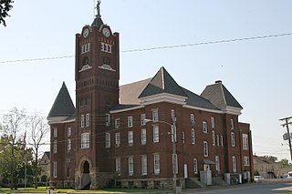
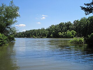
Jackson County is located in the Arkansas Delta in the U.S. state of Arkansas. The county is named for Andrew Jackson, a national hero during the War of 1812. By the county's formation in 1829, Jackson had become the seventh President of the United States. Jackson County is home to seven incorporated towns and four incorporated cities, including Newport, the largest city and county seat. The county is also the site of numerous unincorporated communities and ghost towns. Occupying 633.94 square miles (164,190 ha), Jackson County is the 41st largest county of the 75 in Arkansas. As of the 2010 Census, the county's population is 17,997 people in 7,601 households. Based on population, the county is the 40th-largest county in Arkansas. Although terrain rises in the west, most of Jackson County is within the Arkansas Delta, characterized by largely flat terrain with fertile soils. Historically covered in forest, bayous and swamps, the area was cleared for agriculture by early settlers. It is drained by the White River.

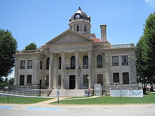
Craighead County is a county located in the U.S. state of Arkansas. As of the 2010 census, the population was 96,443. The county has two county seats — Jonesboro and Lake City. Craighead County is Arkansas's 58th county, formed on February 19, 1859, and named for state Senator Thomas Craighead. It is one of several dry counties within the state of Arkansas, in which the sale of alcoholic beverages is largely prohibited.

Crowley's Ridge Parkway is a 212.0-mile-long (341.2 km) National Scenic Byway in northeast Arkansas and the Missouri Bootheel along Crowley's Ridge in the United States. Motorists can access the parkway from US Route 49 (US 49) at its southern terminus near the Helena Bridge over the Mississippi River outside Helena-West Helena, Arkansas, or from Missouri Route 25 (Route 25) near Kennett, Missouri. The parkway runs along Crowley's Ridge, a unique geological formation, and also parts of the St. Francis National Forest, the Mississippi River and the Mississippi Alluvial Plain. Along the route are many National Register of Historic Places properties, Civil War battlefields, parks, and other archeological and culturally significant points.

Highway 1 is a north–south state highway in east Arkansas. The route of 159.88 miles (257.30 km) runs from US Route 278 (US 278) in McGehee north to Supplemental Route BB at the Missouri state line. One of the original 1926 state highways, Highway 1 has remained very close to its original routing. The highway contains an overlap of approximately 50 miles (80 km) with U.S. Route 49.

Highway 69 is a designation for three north–south state highways in northeast Arkansas. A western route of 57.64 miles (92.76 km) runs south from Highway 9 at Melbourne to Highway 14/Highway 367 in Newport. A second route of 15.31 miles (24.64 km) begins at Highway 163 and runs north through Trumann to Highway 158 at Lunsford. A third route begins at U.S. Route 49/Highway 1 (US 49/AR 1) at the city limits of Paragould and runs north to terminate at US 412 in the city.
Highway 118 is a designation for two state highways in the Upper Arkansas Delta. One route of 41.43 miles (66.68 km) begins at US Highway 64 (US 64) and Highway 149 east to Mississippi County Road 495 near the Mississippi River levee. A second route of 4.29 miles (6.90 km) runs from US 70/US 79 in West Memphis to US 64 in Marion. Both routes are maintained by the Arkansas State Highway and Transportation Department (AHTD).
Highway 163 is a north–south state highway in Northeast Arkansas. The highway begins at Wittsburg and runs 42.57 miles (68.51 km) northeast to Highway 1, Highway 1 Business (AR 1B) and Crowley's Ridge Parkway (CRP) in Jonesboro. A spur route runs in Jonesboro. All routes are maintained by the Arkansas Department of Transportation (ArDOT). Almost all of the route is concurrent with Crowley's Ridge Parkway, with a portion also serving as an Arkansas Heritage Trail for its use during the Civil War.
Highway 198 is a designation for three state highways in the Upper Arkansas Delta. One route of 2.45 miles (3.94 km) in Trumann runs from Highway 69 east to Highway 463. A second route of 2.70 miles (4.35 km) connects Highway 140 and Highway 77. A third route of 3.38 miles (5.44 km) runs from US Highway 61 (US 61) near Grider east to the Sans Souci Landing on the Mississippi River. All routes are maintained by the Arkansas State Highway and Transportation Department (AHTD).
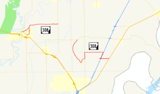
Highway 308 is a designation for two east–west state highways in the Arkansas Delta region of eastern Arkansas. One segment of 6.21 miles (9.99 km) runs east from U.S. Route 63 Business (US 63B) in Marked Tree to the Marked Tree Municipal Airport. A second route of 10.94 miles (17.61 km) begins at Highway 118 at Whitton and runs east to US 61 at Frenchman's Bayou. Both routes are maintained by the Arkansas State Highway and Transportation Department (AHTD).
Eleven special routes of U.S. Route 63 currently exist. Six of them lie within the state of Arkansas. There is also one former routing that has been removed from the system.

Whitehall, Arkansas is an unincorporated community in Scott Township, Poinsett County, Arkansas, United States. Whitehall is located at the intersection of Arkansas Highway 1 and Arkansas Highway 214.

Arkansas Highway 75 is a north–south state highway in Arkansas. The route runs 42.62 miles (68.59 km) from Highway 50 north to Interstate 555/U.S. Route 63/US 63B/AR 14.
Payneway is an unincorporated community in Little River Township, Poinsett County, Arkansas, United States. It is located west of Marked Tree near the intersection of Arkansas Highway 463 and Arkansas Highway 14.
Lake Poinsett State Park is a 132-acre (53 ha) Arkansas state park on Crowley's Ridge in Poinsett County, Arkansas in the United States. The park was formed after the damming of Distress Creek to create a recreational lake in the county in 1960. The park is located along the western bank of the lake and is open for year-round for camping/picnicking. Boat rentals are available from February to November.
Mount Olive is an unincorporated community in Poinsett County, Arkansas, United States. Mount Olive is located at the junction of Arkansas Highway 149 and Arkansas Highway 322, 3.5 miles (5.6 km) south of Marked Tree.
Northern Ohio is an unincorporated community in Poinsett County, Arkansas, United States. Northern Ohio is located on Arkansas Highway 75, 2.75 miles (4.43 km) southwest of Marked Tree. A resettlement community was founded at Northern Ohio in 1936 on land bought from the Northern Ohio Cooperage Company.
Weed is an unincorporated community in Poinsett County, Arkansas, United States. Weed is located on the north bank of the St. Francis River and the BNSF Railway near the northwest border of Marked Tree.

Judd Hill is an unincorporated community in Poinsett County, Arkansas, United States. Judd Hill is located on Arkansas Highway 214, 5 miles (8.0 km) south of Trumann. The Judd Hill Cotton Gin, which is listed on the National Register of Historic Places, is located in Judd Hill. Judd Hill was named for banker and businessman Orange Judd Hill, who founded the community.