
Hensley is a census-designated place (CDP) in Pulaski County, Arkansas, United States. The population was 139 at the 2010 census. It is part of the Little Rock–North Little Rock–Conway Metropolitan Statistical Area.
Bismarck is a rural unincorporated community and census-designated place (CDP) in Hot Spring County, Arkansas. It was first listed as a CDP in the 2020 census with a population of 2,332. It is located between Hot Springs and Caddo Valley, centered around the intersection of State Hwy 7 and State Hwy 84 in Hot Spring County, Arkansas, United States.
Armorel is an unincorporated community and census-designated place (CDP) in Mississippi County, Arkansas, United States. As of the 2020 census, it had a population of 312. It is in a largely rural area with most of its land devoted to forests and farms. Most of the town lies between Arkansas highways 18 and 312. The town's name was formed from the abbreviations of Arkansas and Missouri, along with the first three initials of its founder, Wilson.
Magnet Cove is a census-designated place (CDP) and former town in Hot Spring County, Arkansas, United States. It is located in the Ouachita Mountains southeast of Hot Springs, on Arkansas Highway 51 north of U.S. Highway 270. As of the 2020 census, the town of Magnet Cove had a population of 692.

Roland is a census-designated place in Pulaski County, Arkansas, United States. It is part of the Central Arkansas metropolitan area. Per the 2020 census, the population was 820.
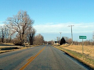
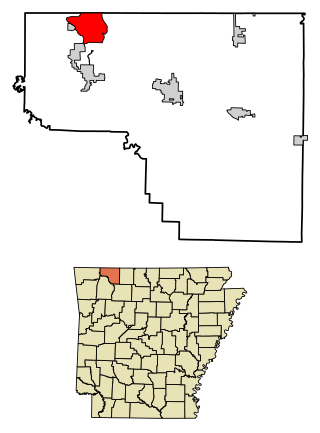
Maysville is an unincorporated community and census-designated place (CDP) in Benton County, Arkansas, United States. It is the westernmost settlement in the state of Arkansas. Per the 2020 census, the population was 117. It is located in the Northwest Arkansas region.

New Blaine is an unincorporated community and census-designated place (CDP) in Logan County, Arkansas, United States. Per the 2020 census, the population was 173.
Earlie Stancel Fires is a retired National Museum of Racing and Hall of Fame jockey.
Appleton is an unincorporated community and census-designated place (CDP) in Griffin Township, Pope County, Arkansas, United States. It was first listed as a CDP in the 2020 census with a population of 399.
Oak Grove is an unincorporated community and census-designated place (CDP) in Moreland Township, Pope County, Arkansas, United States. It was first listed as a CDP in the 2020 census with a population of 177.
William H. "Jinks" Fires is an American Thoroughbred racehorse trainer. He is the trainer of 2011 Arkansas Derby winner Archarcharch which finished fifteenth in the Kentucky Derby.

Avilla is a census-designated place in Saline County, Arkansas, United States. Per the 2020 census, the population was 1,325.

Hagarville is a census-designated place in Johnson County, Arkansas, United States. Per the 2020 census, the population was 142.
Holiday Island is a 4,500-acre planned retirement and vacation community in Carroll County, Arkansas, United States. Formerly an unincorporated community and census-designated place (CDP), it voted to incorporate in November 2020. As of the 2020 census, the population was 2,533. Holiday Island is located in the Ozark Mountains on Table Rock Lake, near Eureka Springs, Arkansas and only an hour from Branson, Missouri, Fayetteville, Arkansas, and Bentonville, Arkansas. Community growth has been fueled by the expansion of the corporate giants headquartered in Northwest Arkansas, the entertainment attractions in Eureka Springs and Branson, the visitor traffic from the Crystal Bridges Museum of American Art, Pea Ridge National Military Park, and Roaring River State Park, and the influence of the state's largest University, the University of Arkansas.

Lost Bridge Village is a residential subdivision near the town of Garfield in Benton County, Arkansas, United States. Per the 2020 census, the population was 397. It is located in the Northwest Arkansas region.
Woodlawn is a census-designated place in Cleveland County, Arkansas, United States. Per the 2020 census, the population was 174.

Yarborough Landing is a census-designated place in Little River County, Arkansas, United States. Per the 2020 census, the population was 457.
Deer is an unincorporated community and census-designated place (CDP) in Newton County, Arkansas, United States. Deer is located on Arkansas Highway 16, 12.5 miles (20.1 km) south of Jasper. Deer has a post office with ZIP code 72628.
Lacey is an unincorporated community and census-designated place (CDP) in Drew County, Arkansas, United States. Lacey is located at the junction of U.S. Route 425 and Arkansas Highway 133, 12.4 miles (20.0 km) south-southwest of Monticello. It was first listed as a CDP in the 2020 census with a population of 139.
Halley is an unincorporated community and census-designated place (CDP) in Desha County, Arkansas, United States. It was first listed as a CDP in the 2020 census with a population of 44.


