Although there were settlers in the Dubach area as early as the late-1840s, the town's origins date to the arrival of the Arkansas Southern Railway in 1898. With the coming of the railroad, the way was opened for the development of the lumber industry. In 1899, Fred B. Dubach, a lumberman from St. Louis, Missouri, arrived in the area and started the Dubach Lumber Company. Shortly thereafter he built a large house and a lumber mill was located across the road. An old aerial photograph indicates that the lumber mill was by far the largest building in town and visually dominated the townscape. Undoubtedly the Dubach Lumber Company was a major factor in the growth and development of what in 1901 was chartered as the town of Dubach. A few years later (c. 1906), Dubach sold his mill and home and returned to St, Louis. Dubach's home still stands and is listed on the National Register of Historic Places. The sawmill no longer exists.
In the fall of 2005, Dubach voters defeated a bond issue that would have funded renovations to Hico Elementary and Dubach High schools. Despite a well-spoken campaign by high school principal Donna Doss, voters killed the issue by a wide margin. Local media speculated that the economic effects of Hurricane Katrina may have swayed voters to err on the side of caution with regards to new taxation. The high school closed and students now attend Ruston High School. Only Dubach Elementary School remains.
Water tower
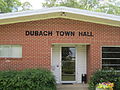
Town Hall
Dubach High School
Aerial View of Dubach, Louisiana
Geography
According to the United States Census Bureau, the town has a total area of 1.5 square miles (3.9km2), of which 1.4 square miles (3.6km2) is land and 0.04 square miles (0.10km2) (2.72%) is water.
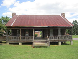
The Autrey house (and museum) just west of town is the oldest home in the area and is an excellent example of the early and rare form of frontier architecture.
Festivals
Dubach is also home to the Louisiana Chicken Festival, held in late September.
Notable people
Bill Doss, an American rock musician and native of Dubach.[4]
This page is based on this Wikipedia article Text is available under the CC BY-SA 4.0 license; additional terms may apply. Images, videos and audio are available under their respective licenses.