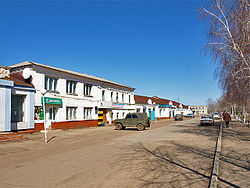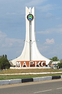
Marks, also spelled Marx, named after Karl Marx, is a town in Saratov Oblast, Russia, located 60 kilometers (37 mi) northeast of Saratov, the administrative center of the oblast. Population: 31,531 (2010 Census); 32,849 (2002 Census); 31,908 (1989 Census).

Krasnoarmeysk is a town in Saratov Oblast, Russia, located 75 kilometers (47 mi) south of Saratov, the administrative center of the oblast. Population: 24,364 (2010 Census); 25,411 (2002 Census); 24,055 (1989 Census).

Alexandrovo-Gaysky District is an administrative and municipal district (raion), one of the thirty-eight in Saratov Oblast, Russia. It is located in the southeast of the oblast. The area of the district is 2,700 square kilometers (1,000 sq mi). Its administrative center is the rural locality of Alexandrov Gay. Population: 16,855 ; 17,763 (2002 Census); 17,003 (1989 Census). The population of Alexandrov Gay accounts for 57.7% of the district's total population.

Baltaysky District is an administrative and municipal district (raion), one of the thirty-eight in Saratov Oblast, Russia. It is located in the north of the oblast. The area of the district is 1,254 square kilometers (484 sq mi). Its administrative center is the rural locality of Baltay. Population: 12,282 ; 13,722 (2002 Census); 12,400 (1989 Census). The population of Baltay accounts for 31.5% of the district's total population.

Bazarno-Karabulaksky District is an administrative and municipal district (raion), one of the thirty-eight in Saratov Oblast, Russia. It is located in the north of the oblast. The area of the district is 2,300 square kilometers (890 sq mi). Its [[administrative center]] is the urban locality of Bazarny Karabulak. Population: 31,841 ; 36,571 (2002 Census); 36,391 (1989 Census). The population of Bazarny Karabulak accounts for 30.9% of the district's total population.
Dergachyovsky District is an administrative and municipal district (raion), one of the thirty-eight in Saratov Oblast, Russia. It is located in the southeast of the oblast. The area of the district is 4,500 square kilometers (1,700 sq mi). Its administrative center is the urban locality of Dergachi. Population: 21,104 ; 26,043 (2002 Census); 29,971 (1989 Census). The population of Dergachi accounts for 39.2% of the district's total population.
Fyodorovsky District is an administrative and municipal district (raion), one of the thirty-eight in Saratov Oblast, Russia. It is located in the center of the oblast. The area of the district is 2,500 square kilometers (970 sq mi). Its administrative center is the urban locality of Mokrous. Population: 20,876 ; 22,108 (2002 Census); 21,579 (1989 Census). The population of Mokrous accounts for 32.2% of the district's total population.

Ivanteyevsky District is an administrative and municipal district (raion), one of the thirty-eight in Saratov Oblast, Russia. It is located in the northeast of the oblast. The area of the district is 2,000 square kilometers (770 sq mi). Its administrative center is the rural locality of Ivanteyevka. Population: 15,186 ; 16,151 (2002 Census); 15,972 (1989 Census). The population of Ivanteyevka accounts for 40.2% of the district's total population.

Kalininsky District is an administrative and municipal district (raion), one of the thirty-eight in Saratov Oblast, Russia. It is located in the west of the oblast. The area of the district is 2,000 square kilometers (770 sq mi). Its administrative center is the town of Kalininsk. Population: 33,302 ; 39,732 (2002 Census); 39,739 (1989 Census). The population of Kalininsk accounts for 49.4% of the district's total population.

Krasnokutsky District is an administrative and municipal district (raion), one of the thirty-eight in Saratov Oblast, Russia. It is located in the south of the oblast. The area of the district is 2,900 square kilometers (1,100 sq mi). Its administrative center is the town of Krasny Kut. Population: 34,676 ; 36,445 (2002 Census); 37,551 (1989 Census). The population of Krasny Kut accounts for 41.6% of the district's total population.

Lysogorsky District is an administrative and municipal district (raion), one of the thirty-eight in Saratov Oblast, Russia. It is located in the southwest of the oblast. The area of the district is 2,300 square kilometers (890 sq mi). Its administrative center is the urban locality of Lysye Gory. Population: 19,948 ; 21,260 (2002 Census); 20,797 (1989 Census). The population of Lysye Gory accounts for 36.0% of the district's total population.

Ozinsky District is an administrative and municipal district (raion), one of the thirty-eight in Saratov Oblast, Russia. It is located in the east of the oblast. The area of the district is 4,100 square kilometers (1,600 sq mi). Its administrative center is the urban locality of Ozinki. Population: 19,147 ; 23,568 (2002 Census); 26,603 (1989 Census). The population of Ozinki accounts for 48.3% of the district's total population.
Perelyubsky District is an administrative and municipal district (raion), one of the thirty-eight in Saratov Oblast, Russia. It is located in the east of the oblast. The area of the district is 3,700 square kilometers (1,400 sq mi). Its administrative center is the rural locality of Perelyub. Population: 14,747 ; 19,280 (2002 Census); 18,131 (1989 Census). The population of Perelyub accounts for 32.4% of the district's total population.
Pitersky District is an administrative and municipal district (raion), one of the thirty-eight in Saratov Oblast, Russia. It is located in the south of the oblast. The area of the district is 2,600 square kilometers (1,000 sq mi). Its administrative center is the rural locality of Piterka. Population: 18,054 ; 19,581 (2002 Census); 18,801 (1989 Census). The population of the administrative center accounts for 30.1% of the district's total population.

Romanovsky District is an administrative and municipal district (raion), one of the thirty-eight in Saratov Oblast, Russia. It is located in the west of the oblast. The area of the district is 1,300 square kilometers (500 sq mi). Its administrative center is the urban locality of Romanovka. Population: 16,226 ; 18,150 (2002 Census); 19,404 (1989 Census). The population of Romanovka accounts for 44.8% of the district's total population.

Samoylovsky District is an administrative and municipal district (raion), one of the thirty-eight in Saratov Oblast, Russia. It is located in the west of the oblast. The area of the district is 2,500 square kilometers (970 sq mi). Its administrative center is the urban locality of Samoylovka. Population: 21,451 ; 25,979 (2002 Census); 26,125 (1989 Census). The population of Samoylovka accounts for 35.3% of the district's total population.

Saratovsky District is an administrative and municipal district (raion), one of the thirty-eight in Saratov Oblast, Russia. It is located in the center of the oblast. The area of the district is 1,900 square kilometers (730 sq mi). Its administrative center is the city of Saratov. Population: 48,105 ; 46,233 (2002 Census); 45,252 (1989 Census).
Turkovsky District is an administrative and municipal district (raion), one of the thirty-eight in Saratov Oblast, Russia. It is located in the northwest of the oblast. The area of the district is 1,400 square kilometers (540 sq mi). Its administrative center is the urban locality of Turki. Population: 12,834 ; 15,852 (2002 Census); 18,409 (1989 Census). The population of Turki accounts for 47.7% of the district's total population.

Yekaterinovsky District is an administrative and municipal district (raion), one of the thirty-eight in Saratov Oblast, Russia. It is located in the northwest of the oblast. The area of the district is 3,000 square kilometers (1,200 sq mi). Its administrative center is the urban locality of Yekaterinovka. Population: 19,798 ; 21,576 (2002 Census); 23,649 (1989 Census). The population of Yekaterinovka accounts for 32.1% of the district's total population.

Yershovsky District is an administrative and municipal district (raion), one of the thirty-eight in Saratov Oblast, Russia. It is located in the eastern central part of the oblast. The area of the district is 4,300 square kilometers (1,700 sq mi). Its administrative center is the town of Yershov. Population: 41,609 ; 50,337 (2002 Census); 53,333 (1989 Census). The population of Yershov accounts for 51.5% of the district's total population.