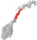
Andøy is the northernmost municipality in Nordland county, Norway. It is part of the Vesterålen archipelago. The main island in the municipality is Andøya. The administrative centre of the municipality is the village of Andenes. Other villages in the municipality include Bjørnskinn, Bleik, Dverberg, Fiskenes, Fornes, Nordmela, Risøyhamn, Skarstein, Å, Åknes, and Åse.

Ankenes is a former municipality in Nordland county, Norway. The 2,028-square-kilometre (783 sq mi) municipality existed from 1884 until 1974. It encompassed most of the present-day Narvik Municipality, surrounding of the town of Narvik which was once its own municipality. The administrative centre of Ankenes was the village of Ankenesstrand, situated along the west side of the Beisfjorden, where the Ankenes Church is located.

Valberg is a former municipality in Nordland county, Norway. The 57-square-kilometre (22 sq mi) municipality existed from 1927 until 1963. The municipality covered the southeastern coast of the island of Vestvågøya in what is now Vestvågøy Municipality. The administrative centre was the village of Valberg where Valberg Church is located.

Borge is a parish and former municipality in Nordland county, Norway. The 200-square-kilometre (77 sq mi) municipality existed from 1838 until 1963. It was located on the northern part of the island of Vestvågøya in what is now Vestvågøy Municipality. The administrative centre of the municipality was the village of Bøstad where Borge Church is located.

Buksnes is a former municipality in Nordland county, Norway. The 102-square-kilometre (39 sq mi) municipality existed from 1838 until its dissolution in 1963. It comprised the western part of the island of Vestvågøya in what is now Vestvågøy Municipality. The administrative centre was located in the village of Gravdal where the main church for the municipality, Buksnes Church, is located.

Nordvik is a former municipality in Nordland county, Norway. The 86-square-kilometre (33 sq mi) municipality existed from 1917 until its dissolution in 1962. The island municipality encompassed the central part of the island of Dønna as well as the smaller surrounding islands of Vandve, Slapøya, Havstein, and many others in what is now the southern part of Dønna Municipality. The municipality had 2 churches: Nordvik Church in the north and Hæstad Church in the south.

Voll is a former municipality in Møre og Romsdal county, Norway. It existed from 1874 until its dissolution in 1964. The 260-square-kilometre (100 sq mi) municipality encompassed the Måndalen and Innfjorden valleys west of the Romsdalsfjorden in the west-central part of the present-day Rauma Municipality. The administrative centre of the village was the village of Måndalen which is also where the main Voll Church is located.

Dønnes is a former municipality in the Helgeland traditional region in Nordland county, Norway. The 88-square-kilometre (34 sq mi) municipality existed from 1888 until its dissolution in 1962. The former municipality encompassed the northern part of the island of Dønna, the western parts of the islands of Tomma and Løkta, and over 300 smaller surrounding islands, islets, and skerries.

Velfjord is a former municipality in Nordland county, Norway. The 600-square-kilometre (230 sq mi) municipality existed from 1875 until its dissolution in 1964. Velfjord municipality was centered around the Velfjorden in what is now Brønnøy Municipality. Most of the municipality is located on the mainland, but it also includes nearly 100 small islands, islet, and skjerries. The administrative centre was the village of Hommelstø at the innermost part of the fjord. Velfjord Church lies just west of Hommelstø.

Leiranger is a former municipality in Nordland county, Norway. The 185-square-kilometre (71 sq mi) municipality existed from 1900 until its dissolution in 1964. The municipality was encompassed the around the Leinesfjorden and the islands surrounding the mouth of the fjord in what is now Steigen Municipality. The administrative centre of Leiranger was the village of Leines. The village of Leinesfjorden lies at the end of the fjord.

Sør-Rana is a former municipality in Nordland county, Norway. The 777-square-kilometre (300 sq mi) municipality existed from 1929 until 1964. Sør-Rana encompassed an area on both sides of the middle section of the Ranfjorden around where the Sørfjorden and Elsfjorden branch off the main fjord.

Nord-Rana is a former municipality in Nordland county, Norway. The 3,980-square-kilometre (1,540 sq mi) municipality existed from 1839 until its dissolution in 1964. From 1839 until 1844, it was named Nord-Ranen, from 1844 until 1923, it was called Mo, and then from 1923 until 1964 it was named Nord-Rana. The former municipality was located at the innermost part of the Ranfjorden. It encompassed the eastern 90% of what is now Rana Municipality. The administrative centre was the village of Ytteren, just north of the town of Mo i Rana.

Syvde is a former municipality in Møre og Romsdal county, Norway. The municipality existed from 1918 until its dissolution in 1964. The 125-square-kilometre (48 sq mi) municipality included the areas surrounding the Syvdsfjorden in the eastern part of the present-day Vanylven Municipality. The administrative centre of the municipality was the village of Myklebost, at the end of the fjord. Syvde Church was the municipal church.

Sandnessjøen or Stamnes is a former municipality in Nordland county, Norway. The 45-square-kilometre (17 sq mi) municipality existed from 1899 until its dissolution in 1965. The municipality encompassed the northern part of the island of Alsten in what is now Alstahaug Municipality. Originally, it (briefly) also included all of what is now Leirfjord Municipality as well. The administrative centre of the municipality was the town of Sandnessjøen.

is a former municipality in Nordland county, Norway. The 71-square-kilometre (27 sq mi) municipality existed from 1924 until its dissolution in 1964. The municipality included the northern part of the island of Andøya as well as many small surrounding islets and skerries in what is now Andøy Municipality. The administrative centre was the village of Andenes where the Andenes Church is located.

Gimsøy is a former municipality in Nordland county, Norway. The 187-square-kilometre (72 sq mi) municipality existed from 1856 until its dissolution in 1964. It was located in the northwestern part of what is now Vågan Municipality. The municipality consisted mainly of the island of Gimsøya as well as the western part of the larger neighboring island of Austvågøya. The municipalities also included 407 other small islands as well as hundreds of little islets and skerries, all of which are located in the Lofoten archipelago. The administrative centre was located at the village of Gimsøysand, where the Gimsøy Church is located.

Tjøtta is a former municipality in Nordland county, Norway. The 326-square-kilometre (126 sq mi) municipality existed from 1862 until its dissolution in 1965. The municipality was centered around the island of Tjøtta plus the mainland to the east and south as well as over 3000 islands, islets, and skerries to the west. The administrative centre of Tjøtta was the village of Tjøtta, located on the island of Tjøtta, where the Tjøtta Church is located.

Kjerringøy is a former municipality in Nordland county, Norway. The 176-square-kilometre (68 sq mi) municipality existed from 1906 until its dissolution in 1964. The municipality included the coastal and island areas around the entrance to the Folda fjord, plus the northern coast of the Mistfjorden to the south of the Folda fjord. About 400 small islands totaling about 11 square kilometres (4.2 sq mi) were part of the municipality. The areas are located in what is now Bodø Municipality and a small part in Steigen Municipality. The administrative centre of the municipality was the village of Kjerringøy where Kjerringøy Church is located.

Bjørnskinn is a former municipality in Nordland county, Norway. The 310-square-kilometre (120 sq mi) municipality existed from 1924 until its dissolution in 1964. The municipality was centered around the Risøysundet strait. It encompassed the southern part of the island of Andøya and the northern part of the island of Hinnøya in the southern part of what is now Andøy Municipality. The administrative centre was the small village of Bjørnskinn where Bjørnskinn Church is located. The largest village in Bjørnskinn was the village of Risøyhamn.

Bud is a former municipality in Møre og Romsdal county, Norway. The municipality existed from 1838 until its dissolution in 1964 when it was merged into Fræna Municipality. The 35-square-kilometre (14 sq mi) municipality was centered around the village of Bud which was the administrative centre of the municipality. Bud Church was the main church for the municipality.


