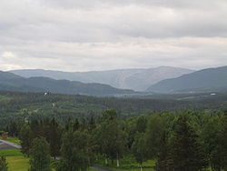
Drevja Municipality Drevja herred | |
---|---|
Coordinates: 65°58′57″N13°15′54″E / 65.98250°N 13.26500°E | |
Country | Norway |
County | Nordland |
District | Helgeland |
Established | 1 July 1927 |
• Preceded by | Vefsn Municipality |
Disestablished | 1 Jan 1962 |
• Succeeded by | Vefsn Municipality |
Administrative centre | Drevja |
Government | |
• Mayor (1960-1961) | Ole J. Slåttrem (Ap) |
Area (upon dissolution) | |
• Total | 195.7 km2 (75.6 sq mi) |
• Rank | #381 in Norway |
Highest elevation | 1,348 m (4,423 ft) |
Population (1961) | |
• Total | 1,010 |
• Rank | #641 in Norway |
• Density | 5.2/km2 (13/sq mi) |
• Change (10 years) | −10.1% |
Demonym | Drevjafolk [2] |
Official language | |
• Norwegian form | Nynorsk [4] |
Time zone | UTC+01:00 (CET) |
• Summer (DST) | UTC+02:00 (CEST) |
ISO 3166 code | NO-1823 [5] |
Drevja is a former municipality in Nordland county, Norway. The municipality existed from 1927 until its dissolution in 1962. It was located in the Drevja valley, north of the Vefsnfjorden in the northern part of the present-day Vefsn Municipality. Drevja Church was the main church for the municipality. [6]
Prior to its dissolution in 1962, the 196-square-kilometre (76 sq mi) municipality was the 381st largest by area out of the 731 municipalities in Norway. Drevja Municipality was the 641st most populous municipality in Norway with a population of about 1,010. The municipality's population density was 5.2 inhabitants per square kilometre (13/sq mi) and its population had decreased by 10.1% over the previous 10-year period. [7] [8]
The municipality of Drevja was established on 1 July 1927 when the large Vefsn Municipality was divided into three municipalities: Drevja Municipality (population: 964) in the north, Grane Municipality (population: 1,746) in the south, and Vefsn Municipality (population: 3,119) in the center. During the 1960s, there were many municipal mergers across Norway due to the work of the Schei Committee. On 1 January 1962, Drevja Municipality (population: 1,001) was merged with the neighboring Elsfjord Municipality (population: 920) and Vefsn Municipality (population: 5,358) and with the town of Mosjøen) to form a new, larger Vefsn Municipality. [9]
During the German occupation of Norway (World War II), the occupiers operated a subcamp of the Stalag 380 prisoner-of-war camp in Drevja. [10]
The municipality was named after the river Drevja which flows from the lake Drevvatnet to the Vefsnfjorden. The name of the river is derived from the word drav which means "rubbish" or "waste". Thus the meaning of the name is something like "the river with unclean water". [11]
The Church of Norway had one parish (sokn) within Drevja Municipality. At the time of the municipal dissolution, it was part of the Vefsn prestegjeld and the Indre Helgeland prosti (deanery) in the Diocese of Sør-Hålogaland. [8]
Parish (sokn) | Church name | Location of the church | Year built |
---|---|---|---|
Drevja | Drevja Church | Nillskogen | 1883 |
The highest point in the municipality was the 1,348-metre (4,423 ft) tall mountain Lukttinden on the border with Elsfjord Municipality. [1]
While it existed, Drevja Municipality was responsible for primary education (through 10th grade), outpatient health services, senior citizen services, welfare and other social services, zoning, economic development, and municipal roads and utilities. The municipality was governed by a municipal council of directly elected representatives. The mayor was indirectly elected by a vote of the municipal council. [12] The municipality was under the jurisdiction of the Hålogaland Court of Appeal.
The mayor (Norwegian : ordfører) of Drevja was the political leader of the municipality and the chairperson of the municipal council. Here is a list of people who held this position: [13]
The municipal council (Herredsstyre) of Drevja was made up of 13 representatives that were elected to four year terms. The tables below show the historical composition of the council by political party.
Party name (in Norwegian) | Number of representatives | |
---|---|---|
Labour Party (Arbeiderpartiet) | 7 | |
Local List(s) (Lokale lister) | 6 | |
Total number of members: | 13 | |
Note: On 1 January 1962, Drevja Municipality became part of Vefsn Municipality. |
Party name (in Norwegian) | Number of representatives | |
---|---|---|
Labour Party (Arbeiderpartiet) | 7 | |
Joint List(s) of Non-Socialist Parties (Borgerlige Felleslister) | 6 | |
Total number of members: | 13 |
Party name (in Norwegian) | Number of representatives | |
---|---|---|
Labour Party (Arbeiderpartiet) | 7 | |
Joint List(s) of Non-Socialist Parties (Borgerlige Felleslister) | 5 | |
Total number of members: | 12 |
Party name (in Norwegian) | Number of representatives | |
---|---|---|
Labour Party (Arbeiderpartiet) | 6 | |
Communist Party (Kommunistiske Parti) | 2 | |
Farmers' Party (Bondepartiet) | 3 | |
List of workers, fishermen, and small farmholders (Arbeidere, fiskere, småbrukere liste) | 1 | |
Total number of members: | 12 |
Party name (in Norwegian) | Number of representatives | |
---|---|---|
Labour Party (Arbeiderpartiet) | 5 | |
List of workers, fishermen, and small farmholders (Arbeidere, fiskere, småbrukere liste) | 4 | |
Local List(s) (Lokale lister) | 3 | |
Total number of members: | 12 |
Party name (in Norwegian) | Number of representatives | |
---|---|---|
Labour Party (Arbeiderpartiet) | 7 | |
Joint List(s) of Non-Socialist Parties (Borgerlige Felleslister) | 4 | |
Local List(s) (Lokale lister) | 1 | |
Total number of members: | 12 | |
Note: Due to the German occupation of Norway during World War II, no elections were held for new municipal councils until after the war ended in 1945. |
Bindal is a municipality in the Helgeland region in the extreme southwest part of Nordland county, Norway. The administrative centre is the village of Terråk. Other villages include Bindalseidet, Holm, Vassås, Horsfjord and Åbygda.
Sømna is a municipality in Nordland county, Norway. It is part of the Helgeland traditional region. The administrative center of Sømna is the village of Vik i Helgeland. Other villages in the municipality include Dalbotn, Sund, Vennesund, and Berg.
Vevelstad is a municipality in Nordland county, Norway. It is part of the Helgeland traditional region. The administrative centre of the municipality is the village of Forvik. The municipality is relatively small and isolated, with no road connections to the rest of Norway. It is only accessible by ferry, despite much of the municipality being located on the mainland.
Herøy is a municipality in Nordland county, Norway. It is part of the Helgeland traditional region. The administrative centre of the municipality is the village of Silvalen. The island municipality is located about 15 kilometres (9.3 mi) west of the town of Sandnessjøen.
Alstahaug is a municipality in Nordland county, Norway. It is part of the Helgeland region. The administrative centre of the municipality is the town of Sandnessjøen. Some of the villages in Alstahaug include Søvika and Tjøtta.
Leirfjord is a municipality in Nordland county, Norway. It is part of the Helgeland traditional region. The administrative centre of the municipality is the village of Leland. Other villages in Leirfjord include Bardal and Sundøya. The large Helgeland Bridge is partly located in the municipality, connecting it to Alstahaug Municipality and the town of Sandnessjøen.
Vefsn is a municipality in Nordland county, Norway. It is part of the Helgeland traditional region. The administrative centre of the municipality is the town of Mosjøen. Some of the notable villages in Vefsn include Drevvassbygda, Elsfjord, and Husvik.
is a municipality in Nordland county, Norway. It is part of the Helgeland traditional region. The administrative centre of the municipality is the village of Trofors. There are several other villages in the municipality including Fallmoen, Grane, Leiren, Majavatn, and Strendene. The European route E6 highway and the Nordland Line railway both run through the municipality from south to north.
Hattfjelldal (Norwegian) or Aarborte (Southern Sami) is a municipality in Nordland county, Norway. It is part of the Helgeland traditional region. The administrative centre of the municipality is the village of Hattfjelldal. Other villages include Grubben, Svenskvollen, and Varntresk. Hattfjelldal Airfield is located in the village of Hattfjelldal.
Hemnes is a municipality in Nordland county, Norway. It is part of the Helgeland traditional region. The administrative centre of the municipality is the village of Korgen. Other villages include Bjerka, Bleikvasslia, Finneidfjord, Hemnesberget, and Sund.
Langenes is a former municipality in Nordland county, Norway. The municipality, which existed from 1919 until 1964, encompassed the western shore of the Gavlfjorden in what is now Øksnes Municipality. It is located on the northern end of the large island of Langøya in the Vesterålen archipelago. The administrative centre was in the village of Stø, just east of the Langenes Church in the northern part of the municipality.
Borge is a former municipality in Nordland county, Norway. The 193-square-kilometre (75 sq mi) municipality existed from 1838 until 1963. It was located on the northern part of the island of Vestvågøya in what is now Vestvågøy Municipality. The administrative centre of the municipality was the village of Bøstad where Borge Church is located. Other villages in the municipality included Borg, Knutstad, and Tangstad.
Nordvik is a former municipality in Nordland county, Norway. The 114-square-kilometre (44 sq mi) municipality existed from 1917 until its dissolution in 1962. The island municipality encompassed the southern part of the island of Dønna as well as the smaller surrounding islands of Vandve, Slapøya, Havstein, and many others in what is now the southern part of Dønna Municipality. The administrative centre was the village of Solfjellsjøen. The municipality had 2 churches: Nordvik Church in the north and Hæstad Church in the south.
Sør-Rana is a former municipality in Nordland county, Norway. The 777-square-kilometre (300 sq mi) municipality existed from 1929 until its dissolution in 1964. The areais now part of Hemnes Municipality.. Sør-Rana encompassed an area on both sides of the middle section of the Ranfjorden around where the Sørfjorden and Elsfjorden branch off the main fjord.
Sandnessjøen is a former municipality in Nordland county, Norway. The 45-square-kilometre (17 sq mi) municipality existed from 1899 until its dissolution in 1965. The municipality encompassed the northern part of the island of Alsta in what is now Alstahaug Municipality. Originally, it (briefly) also included all of what is now Leirfjord Municipality as well. The administrative centre of the municipality was the town of Sandnessjøen.
is a former municipality in Nordland county, Norway. The 71-square-kilometre (27 sq mi) municipality existed from 1924 until its dissolution in 1964. The municipality included the northern part of the island of Andøya as well as many small surrounding islets and skerries in what is now Andøy Municipality. The administrative centre was the village of Andenes where the Andenes Church is located.
Elsfjord is a former municipality in Nordland county, Norway. The 287-square-kilometre (111 sq mi) municipality existed from 1929 until its dissolution in 1962. The municipality included the area around the Elsfjorden and the valley leading up to the fjord. The area is now a part of Vefsn Municipality. The administrative centre was the village of Elsfjord.
Tjøtta is a former municipality in Nordland county, Norway. The 326-square-kilometre (126 sq mi) municipality existed from 1862 until its dissolution in 1965. The municipality was centered around the island of Tjøtta plus the mainland to the east and south as well as over 3000 islands, islets, and skerries to the west. The administrative centre of Tjøtta was the village of Tjøtta, located on the island of Tjøtta, where the Tjøtta Church is located.
Korgen is a former municipality in Nordland county, Norway. The 625.5-square-kilometre (241.5 sq mi) municipality existed from 1918 until its dissolution in 1964. The municipality included the central part of what is now Hemnes Municipality, centered around the river Røssåga. It was located in the traditional district of Helgeland. The administrative centre was the village of Korgen where Korgen Church is located.
Bjørnskinn is a former municipality in Nordland county, Norway. The 310-square-kilometre (120 sq mi) municipality existed from 1924 until its dissolution in 1964. The municipality was centered around the Risøysundet strait. It encompassed the southern part of the island of Andøya and the northern part of the island of Hinnøya in the southern part of what is now Andøy Municipality. The administrative centre was the small village of Bjørnskinn where Bjørnskinn Church is located. The largest village in Bjørnskinn was the village of Risøyhamn.