Flakstad Municipality

Last updated
Flakstad Municipality
Flakstad kommune
Ramberg (Lofoten).jpg
View of a beach in Flakstad
Flag of Flakstad.gif
Flakstad komm.svg
Norway Counties Nordland Position.svg
Nordland within Norway
NO 1859 Flakstad.svg
Flakstad within Nordland
Coordinates: 68°04′45″N13°16′28″E / 68.07917°N 13.27444°E / 68.07917; 13.27444
Country Norway
County Nordland
District Lofoten
Established1 Jan 1838
  Created as Formannskapsdistrikt
Disestablished1 Jan 1964
  Succeeded by Moskenes Municipality
Re-established1 Jan 1976
  Preceded by Moskenes Municipality
Administrative centre Ramberg
Government
  Mayor (2023)Einar Benjaminsen (LL)
Area
  Total178.54 km2 (68.93 sq mi)
  Land169.23 km2 (65.34 sq mi)
  Water9.31 km2 (3.59 sq mi)  5.2%
  Rank#312 in Norway
Highest elevation
[1]
938.71 m (3,079.76 ft)
Population
 (2024)
  Total1,229
  Rank#318 in Norway
  Density6.9/km2 (18/sq mi)
  Change (10 years)
Decrease2.svg −10.2%
Demonym Flakstadfjerding [2]
Official language
[3]
   Norwegian form Neutral
Time zone UTC+01:00 (CET)
  Summer (DST) UTC+02:00 (CEST)
ISO 3166 code NO-1859 [4]
Website Official website

Flakstad is a municipality in Nordland county, Norway. It is part of the traditional district of the island group Lofoten. The administrative centre of the municipality is the village of Ramberg. Other villages in the municipality include Fredvang, Napp, Nusfjord, Sund, and Vareid.

Contents

Ramberg Ramberg La Plage.jpg
Ramberg

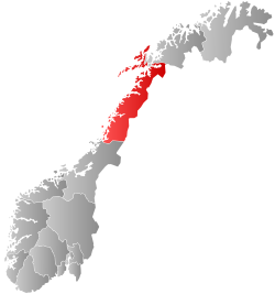
The municipality is located in the Lofoten Islands and comprises the entire island of Flakstadøya and the northern part of the island of Moskenesøya, plus many smaller islets surrounding the main islands. The European route E10 highway runs across the whole municipality.

The 179-square-kilometre (69 sq mi) municipality is the 312th largest by area out of the 357 municipalities in Norway. Flakstad is the 318th most populous municipality in Norway with a population of 1,229. The municipality's population density is 6.9 inhabitants per square kilometre (18/sq mi) and its population has decreased by 10.2% over the previous 10-year period. [5] [6]

General information

Flakstad church Trolig Flakstad krk.JPG
Flakstad church
Skagsanden beach, Flakstad Skagsanden.JPG
Skagsanden beach, Flakstad
Nusfjord is a small harbor with traditional rorbus. Nusfjord6.jpg
Nusfjord is a small harbor with traditional rorbus.

The municipality of Flakstad was established on 1 January 1838 (see formannskapsdistrikt law). On 1 July 1916, the southern part of the municipality (population: 1,306) was separated to form the new Moskenes Municipality. This left Flakstad with 1,667 residents.

During the 1960s, there were many municipal mergers across Norway due to the work of the Schei Committee. On 1 January 1964, Flakstad Municipality (population: 2,067) was merged into the neighboring Moskenes Municipality (population: 2,001), creating a new, larger Moskenes Municipality. This merger, however, only lasted for twelve years. On 1 January 1976, the merger was undone with Moskenes Municipality (population: 1,705) and Flakstad Municipality (population: 2,007) becoming separate municipalities once again. [7]

Name

Flakstad Flakstad.jpg
Flakstad

The municipality (originally the parish) is named after the old Flakstad farm (Old Norse : Flakstaðir or Flatarstaðir) since the first Flakstad Church was built there. The first element of the name is uncertain. It may come from the word flak which may have meant "reckless". Another option is that it derived from the word flag which meant "rock wall", possibly referring to the large cliff near the church site. The last element is the plural form of staðr which means "homestead", "abode", or "farm". [8] [9]

Coat of arms

The coat of arms was granted on 14 July 1989. The official blazon is "Azure, a mooring bollard argent" (Norwegian : I blått en sølv tørnbolt). This means the arms have a blue field (background) and the charge is a mooring bollard which is a type of fixed device used for tying a hawser line from a boat to the dock. The mooring bollard has a tincture of argent which means it is commonly colored white, but if it is made out of metal, then silver is used. The blue color in the field symbolizes the importance of the sea and the mooring bollard was chosen to represent the municipality's seafaring history. The arms were designed by Jorunn Thomassen and Jarle Henriksen. [10] [11] [12]

Churches

The Church of Norway has one parish (sokn) within Flakstad Municipality. It is part of the Lofoten prosti (deanery) in the Diocese of Sør-Hålogaland.

Churches in Flakstad
Parish (sokn)Church nameLocation of the churchYear built
Flakstad Flakstad Church Flakstad 1780

Economy

The municipality's economy is dominated by fishing. The fishing fleet mainly consists of small boats. There are also several fish farm in Flakstad. There is some agriculture in Flakstad, but mostly cattle and sheep farming rather than growing crops. [9]

Government

Flakstad Municipality is responsible for primary education (through 10th grade), outpatient health services, senior citizen services, welfare and other social services, zoning, economic development, and municipal roads and utilities. The municipality is governed by a municipal council of directly elected representatives. The mayor is indirectly elected by a vote of the municipal council. [13] The municipality is under the jurisdiction of the Salten og Lofoten District Court and the Hålogaland Court of Appeal.

Municipal council

The municipal council (Kommunestyre) of Flakstad is made up of 11 representatives that are elected to four year terms. The tables below show the current and historical composition of the council by political party.

Flakstad kommunestyre 20232027 [14]   
Party name (in Norwegian)Number of
representatives
  Labour Party (Arbeiderpartiet)2
  Centre Party (Senterpartiet)4
  Socialist Left Party (Sosialistisk Venstreparti)1
  Flakstad District List (Flakstad distriktsliste)4
Total number of members:11
Flakstad kommunestyre 20192023 [15]   
Party name (in Norwegian)Number of
representatives
  Labour Party (Arbeiderpartiet)3
  Centre Party (Senterpartiet)5
  Socialist Left Party (Sosialistisk Venstreparti)1
  Flakstad District List (Flakstad distriktsliste)1
  Lofoten List (yes to municipal mergers)
(Lofotlista (ja til kommunesammenslåing))
1
Total number of members:11
Flakstad kommunestyre 20152019 [16]   
Party name (in Norwegian)Number of
representatives
  Labour Party (Arbeiderpartiet)2
  Green Party (Miljøpartiet De Grønne)1
  Centre Party (Senterpartiet)5
  Flakstad District List (Flakstad distriktsliste)3
Total number of members:11
Flakstad kommunestyre 20112015 [17]   
Party name (in Norwegian)Number of
representatives
  Labour Party (Arbeiderpartiet)2
  Progress Party (Fremskrittspartiet)1
  Green Party (Miljøpartiet De Grønne)1
  Centre Party (Senterpartiet)4
  Flakstad District List (Flakstad distriktsliste)6
  Fredvang, Krystad and Skjelfjord municipal list
(Fredvang, Krystad og Skjelfjord bygdeliste)
3
Total number of members:17
Flakstad kommunestyre 20072011 [16]   
Party name (in Norwegian)Number of
representatives
  Labour Party (Arbeiderpartiet)4
  Centre Party (Senterpartiet)2
  Flakstad district list (Flakstad Distriktsliste)8
  Fredvang and Krystad local list (Fredvang og Krystad bygdeliste)3
Total number of members:17
Flakstad kommunestyre 20032007 [16]   
Party name (in Norwegian)Number of
representatives
  Labour Party (Arbeiderpartiet)2
  Centre Party (Senterpartiet)6
  Flakstad district list (Flakstad Distriktsliste)7
  Fredvang and Krystad local list (Fredvang og Krystad bygdeliste)2
Total number of members:17
Flakstad kommunestyre 19992003 [16]   
Party name (in Norwegian)Number of
representatives
  Labour Party (Arbeiderpartiet)3
  Centre Party (Senterpartiet)2
  Flakstad district list (Flakstad Distriktsliste)9
  Fredvang and Krystad local list (Fredvang og Krystad bygdeliste)3
Total number of members:17
Flakstad kommunestyre 19951999 [18]   
Party name (in Norwegian)Number of
representatives
  Labour Party (Arbeiderpartiet)2
  Centre Party (Senterpartiet)3
  Socialist Left Party (Sosialistisk Venstreparti)1
  Flakstad district list (Flakstad Distriktsliste)8
  Fredvang and Krystad local list (Fredvang og Krystad bygdeliste)3
Total number of members:17
Flakstad kommunestyre 19911995 [19]   
Party name (in Norwegian)Number of
representatives
  Labour Party (Arbeiderpartiet)6
  Socialist Left Party (Sosialistisk Venstreparti)1
  Flakstad district list (Flakstad Distriktsliste)6
  Fredvang and Krystad local list (Fredvang og Krystad bygdeliste)4
Total number of members:17
Flakstad kommunestyre 19871991 [20]   
Party name (in Norwegian)Number of
representatives
  Labour Party (Arbeiderpartiet)6
  Conservative Party (Høyre)3
  Flakstad district list (Flakstad Distriktsliste)5
  Fredvang and Krystad local list (Fredvang og Krystad bygdeliste)3
Total number of members:17
Flakstad kommunestyre 19831987 [21]   
Party name (in Norwegian)Number of
representatives
  Labour Party (Arbeiderpartiet)6
  Conservative Party (Høyre)2
  Flakstad district list (Flakstad Distriktsliste)6
  Non-party common list for Fredvang-Krystad
(Upolitisk fellesliste for Fredvang-Krystad)
3
Total number of members:17
Flakstad kommunestyre 19791983 [22]   
Party name (in Norwegian)Number of
representatives
  Labour Party (Arbeiderpartiet)4
  Flakstad district list (Flakstad Distriktsliste)10
  Non-party common list for Fredvang-Krystad area
(Upolitisk fellesliste for Fredvang, Krystad og omegn)
3
Total number of members:17
Flakstad kommunestyre 19761979 [23]   
Party name (in Norwegian)Number of
representatives
  Flakstad Common List (Flakstad Samlingsliste)13
  Non-party Common List Fredvang-Krystad
(Upolitisk Fellesliste Fredvang-Krystad)
4
Total number of members:17
Note: On 1 January 1976, Flakstad Municipality was separated from Moskenes Municipality.
Flakstad herredsstyre 19591963 [24]   
Party name (in Norwegian)Number of
representatives
  List of workers, fishermen, and small farmholders (Arbeidere, fiskere, småbrukere liste)2
  Local List(s) (Lokale lister)11
Total number of members:13
Note: On 1 January 1964, Flakstad Municipality became part of Moskenes Municipality.
Flakstad herredsstyre 19551959 [25]   
Party name (in Norwegian)Number of
representatives
  Labour Party (Arbeiderpartiet)2
  List of workers, fishermen, and small farmholders (Arbeidere, fiskere, småbrukere liste)11
Total number of members:13
Flakstad herredsstyre 19511955 [26]   
Party name (in Norwegian)Number of
representatives
  Labour Party (Arbeiderpartiet)1
  List of workers, fishermen, and small farmholders (Arbeidere, fiskere, småbrukere liste)11
Total number of members:12
Flakstad herredsstyre 19471951 [27]   
Party name (in Norwegian)Number of
representatives
  Labour Party (Arbeiderpartiet)2
  Joint List(s) of Non-Socialist Parties (Borgerlige Felleslister)2
  Local List(s) (Lokale lister)8
Total number of members:12
Flakstad herredsstyre 19451947 [28]   
Party name (in Norwegian)Number of
representatives
  List of workers, fishermen, and small farmholders (Arbeidere, fiskere, småbrukere liste)6
  Local List(s) (Lokale lister)6
Total number of members:12
Flakstad herredsstyre 19371941* [29]   
Party name (in Norwegian)Number of
representatives
  Labour Party (Arbeiderpartiet)1
  List of workers, fishermen, and small farmholders (Arbeidere, fiskere, småbrukere liste)3
  Joint List(s) of Non-Socialist Parties (Borgerlige Felleslister)8
Total number of members:12
Note: Due to the German occupation of Norway during World War II, no elections were held for new municipal councils until after the war ended in 1945.

Mayors

The mayor (Norwegian : ordfører) of Flakstad is the political leader of the municipality and the chairperson of the municipal council. Here is a list of people who have held this position (incomplete list): [30]

Geography

Located near the southern end of the Lofoten archipelago, Flakstad comprises all of the island of Flakstadøya and the northern part of the island of Moskenesøya. The islands are connected by the Fredvang Bridges and the Kåkern Bridge. The large lake Solbjørnvatnet lies on the northern part of Moskenesøya in Flakstad. The highest point in the municipality is the 938.71-metre (3,079.8 ft) tall mountain Stjerntinden. [1]

Vestvågøy Municipality lies to the northeast on the island of Vestvågøya, the Vestfjorden lies to the southeast, the Moskenes Municipality lies to the southwest on the island of Moskenesøya, and the Norwegian Sea lies to the northwest.

Climate

Climate data for Ramberg, Flakstad 1961-90
MonthJanFebMarAprMayJunJulAugSepOctNovDecYear
Daily mean °C (°F)−0.3
(31.5)
−0.5
(31.1)
0.2
(32.4)
2.3
(36.1)
6.3
(43.3)
9.5
(49.1)
11.9
(53.4)
12.0
(53.6)
8.8
(47.8)
5.8
(42.4)
2.6
(36.7)
0.5
(32.9)
4.9
(40.8)
Average precipitation mm (inches)175
(6.9)
144
(5.7)
126
(5.0)
95
(3.7)
60
(2.4)
61
(2.4)
85
(3.3)
91
(3.6)
155
(6.1)
218
(8.6)
175
(6.9)
195
(7.7)
1,580
(62.2)
Source: Norwegian Meteorological Institute [31]

Notable people

Related Research Articles

<span class="mw-page-title-main">Bindal</span> Municipality in Nordland, Norway

Bindal is a municipality in the Helgeland region in the extreme southwest part of Nordland county, Norway. The administrative centre is the village of Terråk. Other villages include Bindalseidet, Holm, Vassås, Horsfjord and Åbygda.

<span class="mw-page-title-main">Sømna</span> Municipality in Nordland, Norway

Sømna is a municipality in Nordland county, Norway. It is part of the Helgeland traditional region. The administrative center of Sømna is the village of Vik i Helgeland. Other villages in the municipality include Dalbotn, Sund, Vennesund, and Berg.

<span class="mw-page-title-main">Brønnøy</span> Municipality in Nordland, Norway

Brønnøy is a municipality in Nordland county, Norway. It is part of the Helgeland region. The administrative centre and commercial centre of the municipality is the town of Brønnøysund. A secondary centre is the village of Hommelstø. Other villages include Tosbotn, Lande, Trælnes, and Indreskomo.

<span class="mw-page-title-main">Vevelstad</span> Municipality in Nordland, Norway

Vevelstad is a municipality in Nordland county, Norway. It is part of the Helgeland traditional region. The administrative centre of the municipality is the village of Forvika.

<span class="mw-page-title-main">Herøy, Nordland</span> Municipality in Nordland, Norway

Herøy is a municipality in Nordland county, Norway. It is part of the Helgeland traditional region. The administrative centre of the municipality is the village of Silvalen. The municipality is located about 15 kilometres (9.3 mi) west of the town of Sandnessjøen.

<span class="mw-page-title-main">Leirfjord</span> Municipality in Nordland, Norway

Leirfjord is a municipality in Nordland county, Norway. It is part of the Helgeland traditional region. The administrative centre of the municipality is the village of Leland. Other villages in Leirfjord include Bardalssjøen and Sundøy. The large Helgeland Bridge is partly located in the municipality, connecting it to Alstahaug Municipality and the town of Sandnessjøen.

<span class="mw-page-title-main">Nesna</span> Municipality in Nordland, Norway

Nesna is a municipality in Nordland county, Norway. It is part of the Helgeland traditional region. The administrative centre of the municipality is the village of Nesna. Other villages in Nesna include Handnesneset, Husby, Saura, and Vikholmen.

<span class="mw-page-title-main">Træna</span> Municipality in Nordland, Norway

Træna is a municipality in Nordland county, Norway. It is part of the Helgeland traditional region. The administrative centre of the municipality is the island/village of Husøya. Other population centres include Selvær and Sanna.

<span class="mw-page-title-main">Meløy</span> Municipality in Nordland, Norway

Meløy is a municipality in Nordland county, Norway. It is part of the Salten traditional region. The administrative centre of the municipality is the village of Ørnes. Other villages include Eidbukta, Neverdal, Glomfjord, Halsa, Reipå, Støtt, and Ågskardet.

<span class="mw-page-title-main">Gildeskål</span> Municipality in Nordland, Norway

Gildeskål is a municipality in Nordland county, Norway. It is part of the Bodø Region and the traditional district of Salten. The administrative centre of the municipality is the village of Inndyr. Other villages include Forstranda, Lekanger, Mevik, Mårnes, Nygårdsjøen, Saura, Storvika, Sør-Arnøy, Sørfinnset, and Våg.

<span class="mw-page-title-main">Sørfold</span> Municipality in Nordland, Norway

Sørfold is a municipality in Nordland county, Norway. It is part of the traditional district of Salten. The administrative centre of the municipality is the village of Straumen. Other villages in the municipality include Leirfjordgården, Mørsvikbotn, Røsvika, Rørstad, Styrkesvik, and Øvre Kvarv. The municipality surrounds the Sørfolda fjord and stretches east to the border with Sweden.

<span class="mw-page-title-main">Steigen</span> Municipality in Nordland, Norway

Steigen ('stejgen) is a municipality in Nordland county, Norway. It is part of the traditional district of Salten. The administrative centre of the municipality is the village of Leinesfjord. Other villages include Bogen, Leines, Nordfold, Nordskot, and Sørskot. Engeløy Airport, Grådussan is located in the northern part of the municipality. Måløy–Skarholmen Lighthouse is located in the Vestfjorden in the western part of the municipality. The only road access to the municipality is via the Steigen Tunnel.

<span class="mw-page-title-main">Hamarøy</span> Municipality in Nordland, Norway

Hamarøy is a municipality in Nordland county, Norway. It is part of the traditional district of Salten. The administrative centre of the municipality is the village of Oppeid. Other villages include Drag, Innhavet, Karlsøy, Korsnes, Presteid, Skutvika, Tømmerneset, Tranøy, and Ulvsvåg.

<span class="mw-page-title-main">Lødingen</span> Municipality in Nordland, Norway

Lødingen is a municipality in Nordland county in Norway. Lødingen is located on the southeastern corner of the island of Hinnøya, and is part of the traditional district of Ofoten. The administrative centre of the municipality is the village of Lødingen. The other main part of the municipality is Vestbygda. Lødingen has the nickname "Biketown" because it hosts several annual bicycle races, including "Lofoten Insomnia" and Vestbygd-rittet.

<span class="mw-page-title-main">Værøy Municipality</span> Municipality in Nordland, Norway

Værøy is an island municipality in Nordland county, Norway. It is part of the traditional district of Lofoten. The administrative centre of the municipality is the village of Sørland on the main island of Værøya. The other village in Værøy is Nordland. Most of the residents live in the Sørland area surrounding the main harbor. The old Værøy Lighthouse sits at the end of that harbor.

<span class="mw-page-title-main">Vestvågøy</span> Municipality in Nordland, Norway

Vestvågøy is a municipality in Nordland county, Norway. It is part of the traditional district of Lofoten. The administrative centre of the municipality is the town of Leknes. Some of the villages in the municipality include Ballstad, Borg, Bøstad, Gravdal, Knutstad, Stamsund, and Tangstad. With over 11,300 inhabitants, Vestvågøy is the most populous municipality in all of the Lofoten and Vesterålen regions in Nordland county.

<span class="mw-page-title-main">Vågan</span> Municipality in Nordland, Norway

Vågan is a municipality in Nordland county, Norway. It is part of the traditional district of Lofoten. The administrative centre of the municipality is the town of Svolvær. Some of the villages in Vågan include Digermulen, Gimsøysand, Gravermarka, Henningsvær, Hopen, Kabelvåg, Kleppstad, Laupstad, Liland, Skrova, Straumnes, and Sydalen.

<span class="mw-page-title-main">Bø, Nordland</span> Municipality in Nordland, Norway

is a municipality in Nordland county, Norway. It is part of the Vesterålen region. The administrative centre of the municipality is the village of Straume. In addition to this, Bø municipality consists of several other villages including Steine and Vinje, Gimstad, Fjærvoll, Straumsjøen, Skårvågen, Søberg, Malnes/ Eidet, Guvåg, Hovden, Klakksjorda, Nykvåg, Utskor, Ringstad and Vågen. The area named Bø in Bø municipality is the place where Bø Church is located.

<span class="mw-page-title-main">Øksnes</span> Municipality in Nordland, Norway

Øksnes is a municipality in Nordland county, Norway. It is located on the northwestern part of the large island of Langøya, which is a part of the traditional region of Vesterålen. The administrative centre of the municipality is the village of Myre. Other villages in Øksnes include Alsvåg, Barkestad, Breidstrand, Nyksund, Strengelvåg, and Stø.

<span class="mw-page-title-main">Moskenes Municipality</span> Municipality in Nordland, Norway

Moskenes is a municipality in Nordland county, Norway. The municipality comprises the southern part of the island of Moskenesøya in the traditional district of Lofoten. The administrative centre of the municipality is the village of Reine. Other villages include Sørvågen, Hamnøya, and Å.

References

  1. 1 2 "Høgaste fjelltopp i kvar kommune" (in Norwegian). Kartverket. 16 January 2024.
  2. "Navn på steder og personer: Innbyggjarnamn" (in Norwegian). Språkrådet.
  3. "Forskrift om målvedtak i kommunar og fylkeskommunar" (in Norwegian). Lovdata.no.
  4. Bolstad, Erik; Thorsnæs, Geir, eds. (26 January 2023). "Kommunenummer". Store norske leksikon (in Norwegian). Kunnskapsforlaget.
  5. Statistisk sentralbyrå. "Table: 06913: Population 1 January and population changes during the calendar year (M)" (in Norwegian).
  6. Statistisk sentralbyrå. "09280: Area of land and fresh water (km²) (M)" (in Norwegian).
  7. Jukvam, Dag (1999). "Historisk oversikt over endringer i kommune- og fylkesinndelingen" (PDF) (in Norwegian). Statistisk sentralbyrå.
  8. Rygh, Oluf (1905). Norske gaardnavne: Nordlands amt (in Norwegian) (16 ed.). Kristiania, Norge: W. C. Fabritius & sønners bogtrikkeri. p. 347.
  9. 1 2 Store norske leksikon. "Flakstad" (in Norwegian). Retrieved 17 June 2012.
  10. "Civic heraldry of Norway - Norske Kommunevåpen". Heraldry of the World. Retrieved 31 January 2023.
  11. "Flakstad, Nordland". Flags of the World. Retrieved 31 January 2023.
  12. "Godkjenning av våpen og flagg". Lovdata.no (in Norwegian). Norges kommunal- og arbeidsdepartementet. 9 September 1989. Retrieved 31 January 2023.
  13. Hansen, Tore; Vabo, Signy Irene, eds. (20 September 2022). "kommunestyre". Store norske leksikon (in Norwegian). Kunnskapsforlaget . Retrieved 14 October 2022.
  14. "Kommunestyrevalg 2023 - Nordland". Valg Direktoratet. Retrieved 27 December 2023.
  15. "Tall for Norge: Kommunestyrevalg 2019 - Nordland". Valg Direktoratet. Retrieved 27 October 2019.
  16. 1 2 3 4 "Table: 04813: Members of the local councils, by party/electoral list at the Municipal Council election (M)" (in Norwegian). Statistics Norway.
  17. "Tall for Norge: Kommunestyrevalg 2011 - Nordland". Valg Direktoratet. Retrieved 27 October 2019.
  18. "Kommunestyrevalget 1995" (PDF) (in Norwegian). Oslo-Kongsvinger: Statistisk sentralbyrå. 1996. Retrieved 18 March 2020.
  19. "Kommunestyrevalget 1991" (PDF) (in Norwegian). Oslo-Kongsvinger: Statistisk sentralbyrå. 1993. Retrieved 18 March 2020.
  20. "Kommunestyrevalget 1987" (PDF) (in Norwegian). Oslo-Kongsvinger: Statistisk sentralbyrå. 1988. Retrieved 18 March 2020.
  21. "Kommunestyrevalget 1983" (PDF) (in Norwegian). Oslo-Kongsvinger: Statistisk sentralbyrå. 1984. Retrieved 18 March 2020.
  22. "Kommunestyrevalget 1979" (PDF) (in Norwegian). Oslo: Statistisk sentralbyrå. 1979. Retrieved 18 March 2020.
  23. "Kommunevalgene 1975" (PDF) (in Norwegian). Oslo: Statistisk sentralbyrå. 1977. Retrieved 18 March 2020.
  24. "Kommunevalgene og Ordførervalgene 1959" (PDF) (in Norwegian). Oslo: Statistisk sentralbyrå. 1960. Retrieved 18 March 2020.
  25. "Kommunevalgene og Ordførervalgene 1955" (PDF) (in Norwegian). Oslo: Statistisk sentralbyrå. 1957. Retrieved 18 March 2020.
  26. "Kommunevalgene og Ordførervalgene 1951" (PDF) (in Norwegian). Oslo: Statistisk sentralbyrå. 1952. Retrieved 18 March 2020.
  27. "Kommunevalgene og Ordførervalgene 1947" (PDF) (in Norwegian). Oslo: Statistisk sentralbyrå. 1948. Retrieved 18 March 2020.
  28. "Kommunevalgene og Ordførervalgene 1945" (PDF) (in Norwegian). Oslo: Statistisk sentralbyrå. 1947. Retrieved 18 March 2020.
  29. "Kommunevalgene og Ordførervalgene 1937" (PDF) (in Norwegian). Oslo: Statistisk sentralbyrå. 1938. Retrieved 18 March 2020.
  30. Fiva, Jon H; Sørensen, Rune J.; Vøllo, Reidar, eds. (2024). "Local Candidate Dataset" (PDF).
  31. "eKlima Web Portal". Norwegian Meteorological Institute. Archived from the original on 14 June 2004.