Earlston, East Ayrshire

Last updated

Earlston
Earlston, East Ayrshire - site of old railway crossing.jpg
Earlston hamlet
East Ayrshire UK location map.svg
Red pog.svg
Earlston
Location within East Ayrshire
OS grid reference NS 4060 3541
Council area
Lieutenancy area
Country Scotland
Sovereign state United Kingdom
Police Scotland
Fire Scottish
Ambulance Scottish
List of places
UK
Scotland
55°35′10″N4°31′50″W / 55.5862°N 4.5305°W / 55.5862; -4.5305 Coordinates: 55°35′10″N4°31′50″W / 55.5862°N 4.5305°W / 55.5862; -4.5305

Earlston is a hamlet in Riccarton, East Ayrshire, Scotland. The habitation dates from at least the early 18th century [1] and is near Caprington Castle and Todrigs Mill. It was for many years the site of a large sawmill and a mine pumping engine, and had sidings of the Glasgow and South-Western Railway's Fairlie Branch.

Contents

History

The lane to Todrigs Farm or kennels off Earlston's mainstreet. Old factor's house on the right. Earlston, East Ayrshire - view at entrance lane to Todrigs Farm.jpg
The lane to Todrigs Farm or kennels off Earlston's mainstreet. Old factor's house on the right.

The present day name suggest a link with an earldom such as that of Dundonald or Glencairn, the latter holding the Barony of Caprington until 1683, however in the mid 18th century the spelling is recorded as 'Earle town' [2] and in Scots this can also refer to a person who is hired "To engage for service by payment of a sum" [3] and the expression 'earle-penny' was a "A coin given as a token of engagement of service." [3] Earlston may have been a place where dwellings were provided for Caprington estate workers, many of whom were hired annually at the Dudsday, also Duds' day, or Dud's day hiring fair, a holiday, held at Kilmarnock, originally held at Martinmas that falls on November 11. At this fair farm servants etc would be hired. The name comes from the custom of farm Labourers purchasing new clothes or 'Duds' having been paid their wages for the previous half-year.

Caprington had been held by the Wallace's of Craigie Castle [4] however it passed into the hands of the Cuninghames who held the barony as baronets from 1669 to 1829 when the line became extinct and John Smith assumed the name Cuninghame on behalf of his wife who had inherited the estate. [5]

The hamlet was once the location of the Eglinton Hunt kennels located at the old Todrigs Farm. [6] A fine Ballochmyle red sandstone building was constructed for the factor of the Caprington Estate in 1873. Todrigs Farm was the birthplace of Johnnie Walker of the Johnnie Walker whisky fame. It was sold to finance the purchase of the family's first grocer shop. [7]

The old road from Ayr to Kilmarnock and Glasgow ran quite close by so the site was not as isolated as it is today. [8]

A corn mill, later a thrashing mill used to thrash grain, separating the cereal's seeds from the husk and stalks by a beating action that made all the seeds drop out. Located on the Todrigs Burn it was located to the north of the hamlet with a mill pond standing close to Todrigs Farm however this has been infilled. A large irregular shaped curling pond was located at West Todrigs Farm, west of the farm house and shown in 1897 and 1908 served by the Todrigs Burn is all that survives of the old Caprington Loch (datum 2018). [9] The Todrigs Burn rises in the Coodham area and is also fed by the Slough Burn that rises in the Dankeith Estate.

Earlston lies in a low lying area at 35m above sea level. The 1892 - 1913 OS map shows a new group of four semi-detached houses on the north side of the road facing the older houses that are arranged below the sawmill complex.

A school may not have existed in Earlston however a school and /or Sunday School was located in the 19th century attached to the likely farm building located next to the Blacksyke Tower.

Sawmill and railways

A view along the old railway trackbed towards Blacksyke Tower on the Caprington Golf Course. Trackbed of old Blacksyke Tower branch, Earlston, East Ayrshire - view North.jpg
A view along the old railway trackbed towards Blacksyke Tower on the Caprington Golf Course.
Memorial to the Cuninghame's of Caprington Castle at Riccarton churchyard. Cuninghame's of Caprington Memorial, Riccarton Cemetery, East Ayrshire.jpg
Memorial to the Cuninghame's of Caprington Castle at Riccarton churchyard.

In 1857 the branch to the Caprington Colliery No.40 pit had yet to be built. A building to the east of the railway at the junction to the sawmill is suggestive of a signal box but is later marked as a water meter. The railway continued towards Blacksyke Tower and to several other pits in the area at this time, the line being standard gauge and worked by locomotives by this date. [10]

In the 1855-57 Name Book of the Ordnance Survey the Earlston Cottages and workshop are recorded as being the property of Thomas Smith Cuninghame Esq. of Caprington Castle. [11]

In 1895 the sawmill was a complex of buildings with a network of railway sidings. A series of buildings ran parallel to the railway nearly as far as the road and internally several buildings were present, one with a siding running into it. The sidings may have also brought coal for use by the pumping engine as rails ran close to the site of this building. [12]

The 1892 - 1913 OS map shows several sidings running into the sawmill, a passing loop, a branch running down to the Caprington Colliery No.40 pit and two sidings running into an old pit site that may have been for disposal of coal waste. A short head shunt ran across the road on the trackbed of the old mineral line to Blacksyke, Loreny, etc.

By 1908 the railway had been truncated and no longer ran across the level crossing at the road and the passing loop had become sidings. The network within the sawmill had been simplified and the building opposite the sawmill junction is marked as a water meter. Caprington Colliery Np.40 pit is shown as disused with the line lifted and a new Caprington Colliery No.42 pit with a railway link is shown. [13]

By 1926 the sawmill is no longer marked and Todrigs is shown as being the site of kennels. The railway at this point runs only as far as the old sawmill and no collieries or their branches remain. [14] In 1955 the railways had all been lifted. [15] By 2018 the sawmill buildings had mostly been demolished.

Mining

Todrigs Farm or 'The Kennels'. Todrigs Farm, Earlston, East Ayrshire.jpg
Todrigs Farm or 'The Kennels'.
Plan of line and pits at Caprington by Robert Blane Caprington Colliery west of Earlston (B&W).jpg
Plan of line and pits at Caprington by Robert Blane

No colliery pits were in the hamlet, however the 1908 OS map shows the location of two shafts close to a square raised water tank that represents the site of the 1770s Caprington Newcomen atmospheric pumping engine that helped drain the coalfield. The location of the site from which the 1770s Newcomen Atmospheric Beam engine now housed in the National Museum of Scotland originally came was the 'Caprington Colliery' with its numerous pits and the pumping engine located in Earlston, an old photograph shows its appearance at the time. [16] This engine was donated by Colonel Cuninghame of Caprington to the town of Kilmarnock in 1901 after it had worked for 95 years and after some restoration work by Glenfield and Kennedy it was housed in the Dick Institute in Kilmarnock for many years until it was considered unsafe and donated to the National Museum of Scotland in 1958. In 1998 it was restored and placed on display with a partial replica engine house and powered by electricity (see videos). [17]

The engine had its wooden beam replaced by a cast-iron one in 1837 and the 96 inch long cast iron cylinder had a 30-inch bore and a stroke of 54 to 60 inches. [17] It is not clear where the water was pumped to for disposal as no streams are shown in the immediate area, however a square and embanked tank once stood near by. [18]

No traditional miners' row existed at Earlston however given the number of pits and collieries in the area it is likely that some were resident in the hamlet.

See also

Related Research Articles

Montgreenan railway station

Montgreenan railway station was a railway station near the village of Benslie, three miles north east of the town of Kilwinning, North Ayrshire, Scotland. The station was opened by the Glasgow and South Western Railway on the former Glasgow, Paisley, Kilmarnock and Ayr Railway.

Cunninghamhead railway station

Cunninghamhead railway station (NS369414) was a railway station serving Cunninghamhead Estate, the village of Crossroads, North Ayrshire and the town of Stewarton, East Ayrshire, Scotland. The station was originally part of the Glasgow, Paisley, Kilmarnock and Ayr Railway.

Trabboch

Trabboch is a hamlet in East Ayrshire, Scotland. Built as a miners village in the 1880s, it was owned and leased by Wm. Baird & Co., Ltd. and at one time had 94 dwellings. The miners rows stood, until demolition in 1969, on the Stair and Littlemill road, about two miles south of Stair, in that parish. The name is locally pronounced 'Traaboch'.

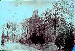
Thorntoun School was opened by Barnardo's in September 1971 for children with emotional difficulties aged 11 to 16 years. The school closed in 1990 and Thorntoun is now a nursing home. The complex lies between the villages of Springside and Crosshouse, Kilmarnock in East Ayrshire, Scotland. The old Thorntoun mansion house was demolished in the late 1960s, leaving the West Lodge, some of the home farm outbuildings, the stables and the walled garden as 'memorials' to the ancient history of the site. Many fine trees remain from the estate policies and the surviving gardens are very well maintained (2007). An entrance with a slight deviation from the old course has been created to serve the large modern buildings which house the nursing home.

Laigh Milton Viaduct

Laigh Milton Viaduct is a railway viaduct near Laigh Milton mill to the west of Gatehead in East Ayrshire, Scotland, about five miles west of Kilmarnock. It is probably the world's earliest surviving railway viaduct on a public railway, and the earliest known survivor of a type of multi-span railway structure subsequently adopted universally.

Gatehead, East Ayrshire Human settlement in Scotland

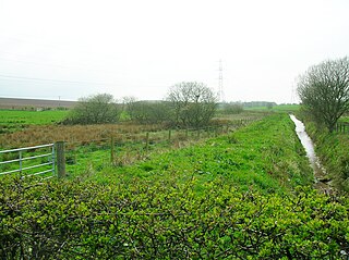
The village or hamlet of Gatehead is located in East Ayrshire, Parish of Kilmaurs, Scotland. It is one and a quarter miles from Crosshouse and one and a half miles from Kilmarnock. In the 18th and 19th centuries the locality was a busy coal mining district. The settlement runs down to the River Irvine where a ford and later a bridge was located.

The village of Springside is in North Ayrshire, Parish of Dreghorn, Scotland. It is three miles from Irvine, 1+12 miles west of Crosshouse, and four miles from Kilmarnock. In the 18th, 19th and mid-20th centuries, the locality was a highly industrialised coal mining district. The settlement is on the Garrier Burn, which forms the boundary with East Ayrshire. Springside had a population of around 1364 in 1991. The A71 now bypasses the village, 14 mile to the south.

River Irvine River in southwest Scotland

The River Irvine is a river that flows through southwest Scotland. Its watershed is on the Lanarkshire border of Ayrshire at an altitude of 810 feet (250 m) above sea-level, near Loudoun Hill, Drumclog, and 7 miles SW by W of Strathaven. It flows 29+12 mi (47.5 km) westward, dividing the old district of Cunninghame from that of Kyle, until it reaches the sea via Irvine Harbour in the form of the Firth of Clyde, and flows into Irvine Bay by the town of Irvine. It has many tributaries, some of which form parish, district and other boundaries.

Riccarton, East Ayrshire Human settlement in Scotland

Riccarton is a village and parish in East Ayrshire, Scotland. It lies across the River Irvine from Kilmarnock, this river forming the boundary between Riccarton and Kilmarnock parishes, and also between the historical districts of Kyle and Cunningham. The name is a corruption of 'Richard's town', traditionally said to refer to Richard Wallace, the uncle of Sir William Wallace. The parish also contains the village of Hurlford.

Industry and the Eglinton Castle estate

The Eglinton Castle estate was situated at Irvine, on the outskirts of Kilwinning, North Ayrshire, Scotland in the former district of Cunninghame. Eglinton Castle, was once home to the Montgomeries, Earls of Eglinton and chiefs of the Clan Montgomery. Eglinton Country Park now occupies part of the site.

Dalmore House and Estate

Dalmore was a country house and small estate in the Parish of Stair, East Ayrshire, on the River Ayr, East Ayrshire, Scotland

Symington, South Ayrshire Human settlement in Scotland

Symington is a conservation village in South Ayrshire, Scotland. It is located in Symington parish, covering 0.41 square kilometres, and lies close to the A77 road from Ayr to Glasgow. Its church, built in 1160, remains one of the finest examples of a Norman church in Scotland.

Shewalton House and estate Human settlement in Scotland

Shewalton House and estate were composed of the 'Lands of Shewalton' and the laird's dwelling, originally a tower castle and later a mansion house on the River Irvine in the Shewalton area, two miles from Irvine and west of Drybridge village, East Ayrshire, Dundonald Parish, Scotland. In 1883 the Boyle's estate of Shewalton was 2,358 acres in extent in Ayrshire and was worth at that time £2,708 a year.

Lands of Doura

The Lands of Doura, Dawra, Dawray, DowreyDowray, Dourey or Douray formed a small estate, at one time part of the Barony of Corsehill and Doura, situated near the Eglinton Estate in the Parish of Kilwinning, North Ayrshire, Scotland.

Old Rome, South Ayrshire Human settlement in Scotland

The old village or hamlet of Old Rome, Rome or Old Rome Ford is located in South Ayrshire, Parish of Dundonald, Scotland. It is one and a half miles from Crosshouse and one and less than a quarter of a mile from Gatehead. In the 18th and 19th centuries the locality was a busy coal mining district and many of the houses have been demolished. The settlement is situated near the River Irvine.

Murder of James Young

The teenager James Young was murdered on or near Blackhill Road close to Fortacres Farm, Gatehead, Parish of Dundonald in Ayrshire by James McWheelan also recorded as James McQueen on Friday 26 or the early hours of Saturday 27 May 1848. The site is recorded in one report as being "on or near" the Toll Road leading from the Fortacres Farm Toll Bar. The parishes boundaries of Symington, Dundonald and Riccarton, Ayrshire meet in this area.

Garrochburn Goods Depot

Garrochburn Goods Depot or Garrochburn Siding was a railway freight facility located off the B744 near the hamlet of Crosshands that lies north-west of Mauchline, East Ayrshire, Scotland. It served the industrial and agricultural requirements for transportation in the vicinity of Crosshands and the surrounding rural area, originally on behalf of the Glasgow and South-Western Railway. Garrochburn Goods Depot was 40.4 miles (65.0 km) from Glasgow, 6.82 miles (10.98 km) from Kilmarnock and 2.72 miles (4.38 km) from Mauchline. The old clachan of Ladeside once stood nearby and the mill at Dalsangan remains as a private house having lost its water supply upon the draining of Loch Brown when the railway was built, that is apart from that of the Garroch or Ladeside Burn that cuts under the railway to the south of the old siding.

Blacksyke Tower

The Blacksyke Tower, Blacksyke Engine House, Caprington Colliery Engine House or even Lusk's Folly is a Scheduled Monument associated with a double lime kiln complex in the Parish of Riccarton and is a building of national importance. The Blacksyke site is a significant survival of early coal and lime industries. The engine house's mock Gothic tower house style is very unusual and rare survival of its type. This late-18th-century engine house would be one of the oldest surviving examples of its kind in the United Kingdom. The track bed of the wagonway and several sidings that linked the complex with the Kilmarnock and Troon Railway can still be clearly made out.

Caprington Loch

What now survives of the old Caprington Loch (NS402352) is situated near Earlston, Riccarton, East Ayrshire, Scotland. The loch was a natural feature, sitting in a hollow on the old Caprington Castle estate. The loch waters drain via the Todrigs Burn that flows into the River Irvine to the east of Gatehead village. It was partly drained, probably sometime after the 1820s, as were so many other lochs, as part of 18th and 19th centuries extensive agricultural improvements and the only area of open water that remains does so as it was once used as a curling pond for the Caprington Castle Estate owners and their employees or tenants.

Bickering Bush

The Bickering bush (NS41863635) thorn grew near Caprington on the lands of Monksholm or Maxholm, Riccarton, East Ayrshire, Scotland. The old farm house at Maxholm sat in hollow on the old Caprington Castle estate and to the north and west its fields bordered the River Irvine. The thorn was located, as recorded on the OS map, near to the confluence of the Kilmarnock Water and the River Irvine, downstream of the Simon's Burn's confluence on the south bank of the river.

References

Notes
  1. "Roy Military Map 1747-55" . Retrieved 13 May 2018.
  2. "Roy Military Map 1747-55" . Retrieved 13 May 2018.
  3. 1 2 "Dictionary of Scots" . Retrieved 13 May 2018.
  4. John Smith (1895). Prehistoric Man in Ayrshire. Elliot Stock. p. 131.
  5. James Paterson (2003). History of the Counties of Ayr and Wigton. James Stillie. p. 649.
  6. Dane Love (2003). Ayrshire : Discovering a County. Fort Publishing. p. 121.
  7. Johnnie Walker and Todrigs
  8. "Roy Military Map 1747-55" . Retrieved 13 May 2018.
  9. "Historic Curling Ponds site" . Retrieved 13 May 2018.
  10. "Ayrshire XXII.8 (Riccarton) Survey date:1857. Publication date:1858" . Retrieved 13 May 2018.
  11. "Ayrshire OS Name Books of 1855-1857. Ayrshire vol. 53/16" . Retrieved 1 August 2018.
  12. "Ayrshire XXII.8 (Dundonald; Riccarton; Symington) Publication date:1896. Revised:1895" . Retrieved 13 May 2018.
  13. "Ayrshire XXII.8 (Dundonald; Riccarton; Symington). Publication date:1909. Revised:1908" . Retrieved 13 May 2018.
  14. "Sheet 78. Kilmarnock & Ayr Publication date:1926" . Retrieved 13 May 2018.
  15. "Sheet 67. Ayr Publication date:1955" . Retrieved 13 May 2018.
  16. "Future Museum" . Retrieved 22 May 2018.
  17. 1 2 Aladair Wham (2013). Ayrshire's Forgotten Railways. The Oakwood Press. p. 137.
  18. "Ayrshire XXII.4 (Dundonald; Kilmarnock; Kilmaurs; Riccarton) Publication date:1910. Revised:1908" . Retrieved 22 May 2018.
Sources
  1. Love, Dane (2003). Ayrshire : Discovering a County. Ayr : Fort Publishing. ISBN   0-9544461-1-9.
  2. Paterson, James (1863–66). History of the Counties of Ayr and Wigton. V. - II - Kyle. J. Stillie. Edinburgh.
  3. Robinson, Mairi (2000). The Concise Scots Dictionary. Aberdeen. ISBN   1-902930-00-2.
  4. Smith, John (1895). Prehistoric Man in Ayrshire. London : Elliot Stock.