Easan Labhar

Last updated

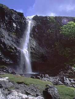
Easan Labhar is a series of waterfalls on the island of Mull, Scotland. [1] It lies on the Allt an Easain Labhair near Gruline west of Salen. There are also unnamed waterfalls on the Allt na Linne burn just to the east.

Scotland Country in Europe, part of the United Kingdom

Scotland is a country that is part of the United Kingdom. Sharing a border with England to the southeast, Scotland is otherwise surrounded by the Atlantic Ocean to the north and west, by the North Sea to the northeast and by the Irish Sea to the south. In addition to the mainland, situated on the northern third of the island of Great Britain, Scotland has over 790 islands, including the Northern Isles and the Hebrides.

Salen, Mull village on the Isle of Mull, Scotland, United Kingdom

Salen is a settlement on the Isle of Mull, Scotland. It is on the east coast of the island, on the Sound of Mull, approximately halfway between Craignure and Tobermory. The full name of the settlement is 'Sàilean Dubh Chaluim Chille'.

The Allt an Easain Labhar is a minor tributary of the Allt Glac an Lin, which itself joins the River Ba on the beach at Killiechronan just before it flows into Loch na Keal.

Loch na Keal sea loch off Mull, Scotland, in the United Kingdom

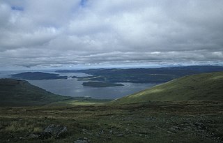
Loch na Keal, meaning Loch of the Kyle, or Narrows, also Loch of the Cliffs, is the principal sea loch on the western, or Atlantic coastline of the island of Mull, in the Inner Hebrides, Argyll and Bute, Scotland. Loch na Keal extends over 20 km inland, almost bisecting Mull, and extending to within 5 km (3 mi) of the eastern shore. The loch gives its name to the Loch na Keal National Scenic Area, one of forty national scenic areas in Scotland.

The name Easan Labhar is from the Gaelic language and means "the talkative waterfalls". [2]

Scottish Gaelic Celtic language native to Scotland

Scottish Gaelic or Scots Gaelic, sometimes also referred to simply as Gaelic, is a Celtic language native to the Gaels of Scotland. A member of the Goidelic branch of the Celtic languages, Scottish Gaelic, like Modern Irish and Manx, developed out of Middle Irish. Most of modern Scotland was once Gaelic-speaking, as evidenced especially by Gaelic-language placenames.

See also

Related Research Articles

Stob Coire Easain mountain in United Kingdom

Stob Coire Easain is a Scottish Munro mountain which reaches a height of 1115 metres (3658 feet), situated 18 kilometres east of Fort William. It stands on the western side of Loch Treig, along with its "twin", the Munro Stob a' Choire Mheadhoin. Collectively the pair are called "The Easains" or the "Stob Corries" and stand just one kilometre apart connected by a high col with an approximate height of 965 metres. The fine corrie of Coire Easain Beag lies in between the two mountains facing north west. Stob Coire Easain’s name translates from the Gaelic as “Peak of the Corrie of the Little Waterfall”. This mountain should not be confused with another Stob Coire Easain, a Munro “Top” on the Munro Stob Coire an Laoigh

Stob a Choire Mheadhoin mountain in the United Kingdom

Stob a' Choire Mheadhoin is a mountain in the Scottish Highlands, it is situated 19 km east of Fort William in the Lochaber area of the Highland council area.

Meall na h-Eilde mountain in United Kingdom

Meall na h-Eilde is a Scottish hill situated in the high ground between the Great Glen and Glen Garry, 23 km north of Fort William in the Highland Council Area.

Grey Corries

The Grey Corries are a range of mountains in the West Highlands of Scotland. The range includes several of Scotland's highest peaks including a number of Munros. The range is bounded to the north by the great extent of Leanachan Forest beyond which is Glen Spean and the Great Glen, to the east by the defile of Lairig Leacach and to the south by upper Glen Nevis and the headwaters of the Abhainn Rath. The ridge continues westwards at a high level to join Aonach Beag, Aonach Mor, Carn Mor Dearg and Ben Nevis.

Eas Allt an Tairbh is a waterfall on the island of Jura, Scotland.

Na h-Easain is a waterfall of Scotland.

Eas Fors

Eas Fors is a waterfall on the island of Mull in Scotland. It is situated on the Allt an Eas Fors south of Dervaig.

Eas Mòr, Glen Brittle

Eas Mòr is a waterfall in Glen Brittle on the island of Skye in Scotland. It lies on the Allt Coire na Bannachdich in a small gorge east of Glenbrittle House.

Easan Bhunachain is a waterfall of Scotland.

Easan Dubh, Knapdale is a waterfall of Scotland.

Easan Dubh, Loch Treig is a waterfall of Scotland.

Easan Dubh waterfall in the United Kingdom

Easan Dubh is a waterfall of Scotland near to Leathad Nan Con Dearga.

Easan Dubha is a waterfall of Scotland.

Easan Garbh is a waterfall of Scotland.

Easan Laogh is a waterfall of Scotland.

Easan Mor is a waterfall of Scotland.

Easan na Gaibhre is a waterfall of Scotland.

Easan nan Toll Dubha is a waterfall of Scotland.

Falls of Glas Allt is a 50-metre (160 ft) waterfall near the head of Loch Muick, Aberdeenshire, Scotland. Queen Victoria liked to take walks here beside the stream flowing from Lochnagar down to Loch Muick. After the death of Prince Albert she had a cottage, Glas-allt-Shiel, rebuilt for her on the delta where the stream flows into the loch.

River Garry, Perthshire river in the United Kingdom

The River Garry is a major tributary of the River Tummel, itself a tributary of the River Tay, in the traditional county of Perthshire in the Scottish Highlands. It emerges from the northeastern end of Loch Garry (56.8193°N 4.2311°W), just to the southeast of the Pass of Drumochter, and flows southeastwards and eastwards down Glen Garry to the narrow Pass of Killiecrankie beyond which it joins the Tummel (56.7182°N 3.7790°W).

References

  1. Ordnance Survey 1:25,000 scale Explorer map series, sheets 309-470
  2. Iain Mac an Tàilleir. "Placenames" (pdf). Pàrlamaid na h-Alba. Retrieved 19 September 2010.

Coordinates: 56°30′15″N6°00′50″W / 56.50418°N 6.01392°W / 56.50418; -6.01392

Geographic coordinate system Coordinate system

A geographic coordinate system is a coordinate system that enables every location on Earth to be specified by a set of numbers, letters or symbols. The coordinates are often chosen such that one of the numbers represents a vertical position and two or three of the numbers represent a horizontal position; alternatively, a geographic position may be expressed in a combined three-dimensional Cartesian vector. A common choice of coordinates is latitude, longitude and elevation. To specify a location on a plane requires a map projection.