East Dorset

Last updated

East Dorset District
Arms of East Dorset and Wimborne District Council.svg
East Dorset UK locator map.svg
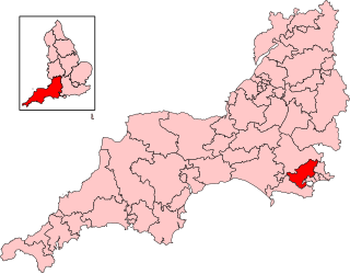
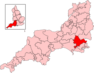
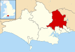
East Dorset shown within Dorset
Coordinates: 50°48′59.84″N1°58′53.36″W / 50.8166222°N 1.9814889°W / 50.8166222; -1.9814889 Coordinates: 50°48′59.84″N1°58′53.36″W / 50.8166222°N 1.9814889°W / 50.8166222; -1.9814889
Sovereign state United Kingdom
Constituent country England
Region South West England
Non-metropolitan county Dorset
StatusAbolished
Admin HQ Wimborne
Incorporated1 April 1974 to 30 March 2019
Government
  TypeNon-metropolitan district council
  BodyEast Dorset District Council
  Leadership Alternative - Sec.31 (Conservative)
   MPs Christopher Chope
Simon Hoare [1]
Michael Tomlinson
Area
  Total136.8 sq mi (354.4 km2)
  Rank (of 309)
Population
 (mid-2018)
  Total89,400
  Density650/sq mi (250/km2)
  Ethnicity
99.0% White
Time zone UTC0 (GMT)
  Summer (DST) UTC+1 (BST)
ONS code 19UD (ONS)
E07000049 (GSS)
OS grid reference SU0130301959
Website www.dorsetforyou.gov.uk

East Dorset was a local government district in Dorset, England. Its council met in Wimborne Minster between 2016 and 2019. [2] [3]

Contents

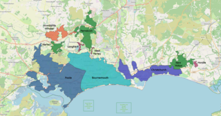
The district (as Wimborne) was formed on 1 April 1974 by merging Wimborne Minster Urban District with Wimborne and Cranborne Rural District, plus the parish of St Leonards and St Ives transferred from the Ringwood and Fordingbridge Rural District in Hampshire. [4] The district was renamed East Dorset with effect from 1 January 1988. The district was abolished in 2019 at the same time that Dorset County Council and the other districts in the county were abolished, with the area becoming part of the Dorset unitary authority on 1 April 2019.

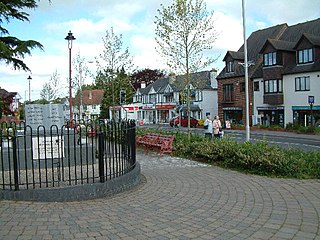
The popularity of the area, being close to the New Forest, Bournemouth and the Dorset coast saw a rapid expansion in housing from the 1970s with the Verwood, Ferndown, West Moors and Corfe Mullen populations more than quadrupling. Rural landscape prevailed in the north and west of the area. Wimborne Minster retained its identity as a historic market town.

The most notable geography is lowland heath, managed by East Dorset Countryside Management Services in partnership with the Forestry Commission. The expansion of housing has led to a massive decrease in the area of this unusual and unique habitat, which once covered 500 km2 but now covers only 15% of that.

Statistics released [5] by the Office for National Statistics show that life expectancy at birth for males in East Dorset was 80.1 years in 2001–2003, the highest in the United Kingdom. Female life expectancy at birth for the same period was 83.4 years, ranking seventh in the UK. The figures for East Dorset during 1991-1993 were 77.9 years for males and 82.5 for females.

Governance

East Dorset District Council was elected every four years, with latterly 36 councillors being elected at each election. After 1976 the Conservative party held a majority on the council apart from a period between the 1995 and 1999 elections when the Liberal Democrats had control. Following the 2015 election the council's politicians were:- [6]

PartyCouncillors
Conservative Party 24
Liberal Democrats 3
Independent 2

The district and its council were abolished on 1 April 2019 and, together with the other 4 Dorset districts outside the greater Bournemouth area, formed a new Dorset unitary authority. [7]

Settlements

Settlements with a population over 2,500 are in bold.

Premises

Until 2016 the council was based at Woodleaze, a large house at Furzehill in the parish of Colehill, just north of the town of Wimborne Minster. Woodleaze had previously served as the headquarters of Wimborne and Cranborne Rural District Council. [8] In 2016 the council moved to Allenview House on Hanham Road in the town centre of Wimborne Minster. [2]

See also

Related Research Articles

<span class="mw-page-title-main">Wimborne Minster</span> Town in Dorset, England

Wimborne Minster is a market town in Dorset in South West England, and the name of the Church of England church in that town. It lies at the confluence of the River Stour and the River Allen, 5 miles (8 km) north of Poole, on the Dorset Heaths, and is part of the South East Dorset conurbation. According to Office for National Statistics data the population of the Wimborne Minster built-up area as of 2014 was 15,552.

<span class="mw-page-title-main">Verwood</span> Human settlement in England

Verwood is a town and civil parish in eastern Dorset, England. The town lies 10 miles (16 km) north of Bournemouth and 13 miles (21 km) north east of Poole as the crow flies. The civil parish comprises the town of Verwood together with the extended village of Three Legged Cross, and in 2014 had a population of 15,170. Verwood is the largest town in Dorset without an upper school.

<span class="mw-page-title-main">Corfe Mullen</span> Human settlement in England

Corfe Mullen is a village in Dorset, England, on the north-western urban fringe of the South East Dorset conurbation. The community had a population of 10,133 at the 2011 Census. It is served by six churches, four pubs, five schools, a library, various shops and local businesses, a village hall, and many community and sports organisations. On 10 December 2019 The Corfe Mullen Parish Council resolved to adopt Town Council status, citing potential financial benefits. In all other aspects Corfe Mullen is still very much a village, albeit a large one.

<span class="mw-page-title-main">Ferndown</span> Human settlement in England

Ferndown is a town and civil parish in Dorset in southern England, immediately to the north of Bournemouth and Poole. The parish, which until 1972 was called Hampreston, includes the communities of Hampreston, Longham, Stapehill and Trickett's Cross. At the 2011 Census, the population of the parish was 26,559, making Ferndown the largest inland town in Dorset in terms of population, being larger than Dorchester.

<span class="mw-page-title-main">Colehill</span>

Colehill is a parish neighbouring Wimborne Minster, in Dorset, England, with a population of 7,000 (2001), shrinking slightly to 6,927 people at the 2011 census.

<span class="mw-page-title-main">Cranborne Chase</span> Plateau in southern England

Cranborne Chase is an area of central southern England, straddling the counties Dorset, Hampshire and Wiltshire. It is part of the Cranborne Chase and West Wiltshire Downs Area of Outstanding Natural Beauty (AONB).

<span class="mw-page-title-main">Mid Dorset and North Poole (UK Parliament constituency)</span>

Mid Dorset and North Poole is a constituency represented in the House of Commons of the UK Parliament since 2015 by Michael Tomlinson, a Conservative.

<span class="mw-page-title-main">North Dorset (UK Parliament constituency)</span>

North Dorset is a constituency represented in the House of Commons of the UK Parliament since 2015 by Simon Hoare, a Conservative.

<span class="mw-page-title-main">South East Dorset conurbation</span> Population centre in Southern England

The South East Dorset conurbation is a multi-centred conurbation on the south coast of Dorset in England.

<span class="mw-page-title-main">Wilts & Dorset</span> British bus operator

Wilts & Dorset is a bus and coach operator providing services in East Dorset, South Wiltshire, and West Hampshire. It operates services under the morebus brand around Bournemouth and Poole, and under the Salisbury Reds brand around Salisbury and Amesbury. It is part of Go South Coast, a subsidiary of the Go-Ahead Group.

<span class="mw-page-title-main">2007 East Dorset District Council election</span>

The 2007 East Dorset District Council election took place on 3 May 2007 to elect members of East Dorset District Council in Dorset, England. The whole council was up for election and the Conservative Party stayed in overall control of the council.

<span class="mw-page-title-main">2011 East Dorset District Council election</span>

The 2011 East Dorset District Council election took place on 5 May 2011 to elect members of East Dorset District Council in Dorset, England. The whole council was up for election and the Conservative Party stayed in overall control of the council.

<span class="mw-page-title-main">2015 East Dorset District Council election</span>

The 2015 East Dorset District Council election took place on 7 May 2015 in order to elect members of the East Dorset District Council in Dorset, England. The whole council was up for election after boundary changes reduced the number of seats by seven. The Conservative Party stayed in overall control of the council.

References

  1. "Dorset North Parliamentary constituency". Election 2015. BBC. Retrieved 11 May 2015.
  2. 1 2 "Relocation of East Dorset District Council offices". Dorset Council. 22 September 2016. Retrieved 30 June 2022.
  3. "Contact East Dorset District Council". www.dorsetforyou.gov.uk.
  4. "The English Non-Metropolitan Districts (Definition) Order 1972", legislation.gov.uk , The National Archives, SI 1972/2039, retrieved 30 June 2022
  5. Life expectancy at birth in the United Kingdom, Office for National Statistics
  6. "Local election results for Christchurch and East Dorset". dorsetforyou.com. 13 May 2015. Archived from the original on 13 May 2015. Retrieved 17 May 2015.
  7. Ministry of Housing, Communities and Local Government (25 May 2018). "The Bournemouth, Dorset and Poole (Structural Changes) Order 2018". legislation.gov.uk. Retrieved 28 May 2018.
  8. "Town and Country Planning Act 1947". London Gazette (41718): 3405. 26 May 1959. Retrieved 30 June 2022. ...and at the Wimborne and Cranborne R.D.C. Offices, Woodleaze, Furzehill, Wimborne...