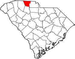
East Gaffney, South Carolina | |
---|---|
Coordinates: 35°4′59″N81°37′42″W / 35.08306°N 81.62833°W Coordinates: 35°4′59″N81°37′42″W / 35.08306°N 81.62833°W | |
Country | United States |
State | South Carolina |
County | Cherokee |
Area | |
• Total | 3.03 sq mi (7.85 km2) |
• Land | 3.02 sq mi (7.83 km2) |
• Water | 0.01 sq mi (0.02 km2) |
Elevation | 771 ft (235 m) |
Population | |
• Total | 2,882 |
• Density | 953.04/sq mi (368.00/km2) |
Time zone | UTC-5 (Eastern (EST)) |
• Summer (DST) | UTC-4 (EDT) |
FIPS code | 45-22075 [4] |
GNIS feature ID | 1231253 [2] |
East Gaffney is a census-designated place (CDP) in Cherokee County, South Carolina, United States. The population was 3,085 at the 2010 United States Census. [5]
East Gaffney is located in central Cherokee County at 35°4′59″N81°37′42″W / 35.08306°N 81.62833°W (35.083060, -81.628302), [6] on the eastern border of the city of Gaffney, the county seat. U.S. Route 29 is the main road through the community, leading west into Gaffney and northeast 7 miles (11 km) to Blacksburg. Interstate 85 passes north of the community, with access from Exit 95.
According to the United States Census Bureau, the CDP has a total area of 3.1 square miles (7.9 km2), of which 0.01 square miles (0.02 km2), or 0.24%, is water. [5]
Historical population | |||
---|---|---|---|
Census | Pop. | %± | |
2020 | 2,882 | — | |
U.S. Decennial Census [7] |
As of the census [4] of 2000, there were 3,349 people, 1,380 households, and 916 families residing in the CDP. The population density was 1,058.0 people per square mile (407.9/km2). There were 1,563 housing units at an average density of 493.8/sq mi (190.4/km2). The racial makeup of the CDP was 77.64% White, 20.39% African American, 0.09% Native American, 0.33% Asian, 0.03% Pacific Islander, 0.87% from other races, and 0.66% from two or more races. Hispanic or Latino of any race were 2.57% of the population.
There were 1,380 households, out of which 28.3% had children under the age of 18 living with them, 41.9% were married couples living together, 18.8% had a female householder with no husband present, and 33.6% were non-families. 27.8% of all households were made up of individuals, and 9.3% had someone living alone who was 65 years of age or older. The average household size was 2.42 and the average family size was 2.96.
In the CDP, the population was spread out, with 24.7% under the age of 18, 9.1% from 18 to 24, 29.3% from 25 to 44, 23.3% from 45 to 64, and 13.6% who were 65 years of age or older. The median age was 36 years. For every 100 females, there were 96.3 males. For every 100 females age 18 and over, there were 91.3 males.
The median income for a household in the CDP was $24,527, and the median income for a family was $32,167. Males had a median income of $26,156 versus $21,009 for females. The per capita income for the CDP was $12,902. About 16.0% of families and 22.6% of the population were below the poverty line, including 28.5% of those under age 18 and 13.0% of those age 65 or over.
Cherokee County is a county in the U.S. state of South Carolina. As of the 2020 census, the population was 56,216. The county seat is Gaffney. The county was formed in 1897 from parts of York, Union, and Spartanburg Counties. It was named for the Cherokee people who historically occupied this area prior to European encounter.
Farm Loop is a census-designated place (CDP) in Matanuska-Susitna Borough, Alaska, United States. It is part of the Anchorage, Alaska Metropolitan Statistical Area. At the 2020 census the population was 2,747, up from 1,028 in 2010.
Bethlehem is a census-designated place (CDP) in Alexander County, North Carolina, United States. The population was 4,214 at the 2010 census. It is part of the Hickory–Lenoir–Morganton Metropolitan Statistical Area.
Mountain View is a census-designated place (CDP) in Catawba County, North Carolina, United States. The population was 3,552 at the 2010 census. It is part of the Hickory–Lenoir–Morganton Metropolitan Statistical Area.
St. Stephens is a census-designated place (CDP) in Catawba County, North Carolina, United States. The population was 8,759 at the 2010 census, down from 9,439 in 2000. It is part of the Hickory–Lenoir–Morganton Metropolitan Statistical Area.
Lowesville is a census-designated place (CDP) in Lincoln County, North Carolina, United States. The population was 2,945 at the 2010 census, up from 1,440 in 2000.
Bell is a census-designated place (CDP) in Adair County, Oklahoma, United States. The population was 535 at the 2010 census, an 11.1 percent decline from the figure of 602 recorded in 2000.
Dry Creek is an unincorporated community and census-designated place (CDP) in Cherokee County, Oklahoma, United States. The population was 227 at the 2010 census.
Shady Grove is an unincorporated community and census-designated place (CDP) in Cherokee County, Oklahoma, United States. The population was 556 at the 2010 census. This is not to be confused with the similarly-named Shady Grove in McIntosh County, or the Shady Grove in Pawnee County.
Woodall is an unincorporated community and census-designated place (CDP) in Cherokee County, Oklahoma, United States. The population was 823 at the 2010 census.
Blacksburg is a small town in Cherokee County, South Carolina, United States. The population was 1,848 at the 2010 census. The communities of Cherokee Falls, Kings Creek, Cashion Crossroads, Buffalo, and Mount Paran are located near the town.
Gaffney is a city in and the seat of Cherokee County, South Carolina, United States, in the Upstate region of South Carolina. Gaffney is known as the "Peach Capital of South Carolina". The population was 12,539 at the 2010 census, with an estimated population of 12,609 in 2019. It is the principal city of the Gaffney, South Carolina, Micropolitan Statistical Area, which includes all of Cherokee County and which is further included in the greater Greenville-Spartanburg-Anderson, South Carolina Combined Statistical Area.
Murphys Estates is a neighborhood in Edgefield County, South Carolina, United States. The population was 1,441 at the 2010 census. It is part of the Augusta, Georgia metropolitan area. The largest-known Irish Traveller community in the US is in Murphy Village, South Carolina, which, as noted in a report by the Florida Ancient Order of Hibernians, is home to approximately 1,500 people with only 11 different surnames.
Red Bank is an unincorporated community and census-designated place (CDP) in Lexington County, South Carolina, United States. The population was 9,617 at the 2010 census, up from 8,811 at the 2000 census. It is part of the Columbia, South Carolina Metropolitan Statistical Area.
Seven Oaks is a census-designated place (CDP) in Lexington County, South Carolina, United States, 8 miles (13 km) northwest of downtown Columbia, the state capital. The population of the CDP was 15,144 at the 2010 census. It is part of the Columbia Metropolitan Statistical Area.
Lake Murray of Richland is a census-designated place (CDP) in Richland County, South Carolina, United States. The population was 5,484 at the 2010 census. It is part of the Columbia, South Carolina Metropolitan Statistical Area.
Valley Falls is a census-designated place (CDP) in Spartanburg County, South Carolina, United States. The population was 6,299 at the 2010 census.
India Hook is a census-designated place (CDP) in York County, South Carolina, United States. The majority of India Hook is annexed into the city of Rock Hill, but as of 2010 India Hook is still considered to be a CDP. It is one of the three communities located on Lake Wylie.
Ranchitos Las Lomas is a census-designated place (CDP) in Webb County, Texas, United States. The population was 266 at the 2010 census. Las Lomas means "the hills" in Spanish. The town prides itself as "the place where nothing ever happened."
Sparrowhawk is an unincorporated community and census-designated place (CDP) in Cherokee County, Oklahoma, United States. The population was 191 as of the 2010 census, at which time the CDP was known as Scraper. The older name of the community was given for Captain Archibald Scraper of the 2nd Regiment, Indian Home Guard. Sparrowhawk takes its name from Sparrow Hawk Mountain, which occupies most of the CDP.