East Gippsland Commonwealth Marine Reserve

Last updated

East Gippsland Commonwealth Marine Reserve
IUCN category VI (protected area with sustainable use of natural resources)
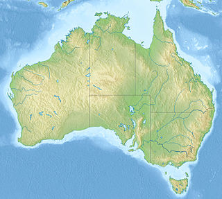
Map showing the East Gippsland Commonwealth Marine Reserve
Location Tasman Sea, Australia
Nearest town Mallacoota, Victoria
Coordinates 38°07′S150°20′E / 38.12°S 150.33°E / -38.12; 150.33 Coordinates: 38°07′S150°20′E / 38.12°S 150.33°E / -38.12; 150.33 [1]
Area4,137 km2 (1,597 sq mi)
EstablishedAugust 31, 2007 (2007-08-31)
Governing body Parks Australia (Commonwealth of Australia)
environment.gov.au/topics/marine/marine-reserves/south-east/east-gippsland

East Gippsland Commonwealth Marine Reserve is a 4,137 km2 marine protected area within Australian waters located in the Tasman Sea near the New South Wales-Victoria border. The reserve was established in 2007 [2] and is part of the South-east Commonwealth Marine Reserve Network.

Marine protected area Protected areas of seas, oceans, estuaries or large lakes

Marine protected areas (MPA) are protected areas of seas, oceans, estuaries or large lakes. These marine areas can come in many forms ranging from wildlife refuges to research facilities. MPAs restrict human activity for a conservation purpose, typically to protect natural or cultural resources. Such marine resources are protected by local, state, territorial, native, regional, national, or international authorities and differ substantially among and between nations. This variation includes different limitations on development, fishing practices, fishing seasons and catch limits, moorings and bans on removing or disrupting marine life. In some situations, MPAs also provide revenue for countries, potentially equal to the income that they would have if they were to grant companies permissions to fish.

Australia Country in Oceania

Australia, officially the Commonwealth of Australia, is a sovereign country comprising the mainland of the Australian continent, the island of Tasmania and numerous smaller islands. It is the largest country in Oceania and the world's sixth-largest country by total area. The neighbouring countries are Papua New Guinea, Indonesia and East Timor to the north; the Solomon Islands and Vanuatu to the north-east; and New Zealand to the south-east. The population of 25 million is highly urbanised and heavily concentrated on the eastern seaboard. Australia's capital is Canberra, and its largest city is Sydney. The country's other major metropolitan areas are Melbourne, Brisbane, Perth and Adelaide.

Tasman Sea A marginal sea of the South Pacific between Australia and New Zealand

The Tasman Sea is a marginal sea of the South Pacific Ocean, situated between Australia and New Zealand. It measures about 2,000 kilometres (1,200 mi) across and about 2,800 kilometres (1,700 mi) from north to south. The sea was named after the Dutch explorer Abel Janszoon Tasman, who was the first recorded European to encounter New Zealand and Tasmania. The British explorer Captain James Cook later extensively navigated the Tasman Sea in the 1770s as part of his first voyage of exploration.

Contents

The reserve includes both warm and temperate waters, with the East Australian Current bringing subtropical water from the north, forming large eddies around Cape Howe. The complex mix of warmer and cooler waters and the seasonality of currents creates conditions for highly productive phytoplankton growth, which supports an abundance of marine life. [3]

East Australian Current The southward flowing western boundary current that is formed from the South Equatorial Current reaching the eastern coast of Australia

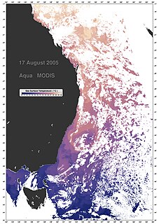
The East Australian Current (EAC) is the southward western boundary current that is formed from the South Equatorial Current (SEC) crossing the Coral Sea and reaching the eastern coast of Australia. At around 15° S near the Australian coast the SEC divides forming the southward flow of the EAC. It is the largest ocean current close to the shores of Australia. The EAC reaches a maximum velocity at 30° S where its flow can reach 90 cm/s. As it flows southward it splits from the coast at around 31° to 32° S. By the time it reaches 33° S it begins to undergo a southward meander while another portion of the transport turns back northward in a tight recirculation. At this location the EAC reaches its maximum transport of nearly 35 Sv. The majority of the EAC flow that does not recirculate will move eastward into the Tasman Front crossing the Tasman Sea just north of the cape of New Zealand. The remaining will flow south on the EAC Extension until it reaches the Antarctic Circumpolar Current. The Tasman Front transport is estimated at 13 Sv. The eastward movement of the EAC through the Tasman Front and reattaching to the coastline of New Zealand forms the East Auckland Current. The EAC also acts to transport tropical marine fauna to habitats in sub-tropical regions along the south east Australian coast.

Cape Howe point in Australia

Cape Howe is a coastal headland in eastern Australia, forming the south-eastern end of the Black-Allan Line, a portion of the border between New South Wales and Victoria. Cape Howe was also the original name of West Cape Howe, a coastal headland near Albany, Western Australia that forms the westernmost extent of the Great Australian Bight.

Phytoplankton Autotrophic members of the plankton ecosystem

Phytoplankton are the autotrophic (self-feeding) components of the plankton community and a key part of oceans, seas and freshwater basin ecosystems. The name comes from the Greek words φυτόν (phyton), meaning "plant", and πλαγκτός (planktos), meaning "wanderer" or "drifter". Most phytoplankton are too small to be individually seen with the unaided eye. However, when present in high enough numbers, some varieties may be noticeable as colored patches on the water surface due to the presence of chlorophyll within their cells and accessory pigments in some species.

Protection

The entirety of the East Gippsland marine reserve area is IUCN protected area category VI and zoned as 'Multiple Use'. [3]

ZoneIUCNActivities permittedArea
(km2)
Recreational fishingCommercial fishingMining
Multiple UseVIYeswith approvalwith approval4,137
[Note 1]

See also

Protected areas of Australia

Protected areas of Australia include Commonwealth and off-shore protected areas managed by the Australian government, as well as protected areas within each of the six states of Australia and two self-governing territories, the Australian Capital Territory and the Northern Territory, which are managed by the eight state and territory governments.

Pacific Ocean Ocean between Asia and Australia in the west, the Americas in the east and Antarctica or the Southern Ocean in the south.

The Pacific Ocean is the largest and deepest of Earth's oceanic divisions. It extends from the Arctic Ocean in the north to the Southern Ocean in the south and is bounded by Asia and Australia in the west and the Americas in the east.

Notes

  1. Summary of permitted activities only, see source for details [4]

Related Research Articles

Kent Group National Park is located in Bass Strait covering the Kent Group islands of Tasmania, Australia. The islands cover an area of 23.74 km2 (9.17 sq mi) while the marine reserve component of the national park which surrounds the islands cover 290 km2 (110 sq mi).

Huon Commonwealth Marine Reserve is a 9,991 km2 marine protected area within Australian waters. The former Tasmanian Seamounts Marine Reserve created in 1999 was incorporated into the Huon reserve in 2007, and is part of the South-east Commonwealth Marine Reserve Network.

Murray Commonwealth Marine Reserve is a 25,803 km2 marine protected area within Australian waters located off the coast of South Australia. The reserve was established in 2007 and is part of the South-east Commonwealth Marine Reserve Network.

Zeehan Commonwealth Marine Reserve is a 19,897 km2 marine protected area within Australian waters located west of Tasmania and extending to near King Island. The reserve was established in 2007 and is part of the South-east Commonwealth Marine Reserve Network.

Franklin Commonwealth Marine Reserve is a 671 km2 marine protected area within Australian waters located off the west coast of north-west Tasmania. The reserve was established in 2007 and is part of the South-east Commonwealth Marine Reserve Network.

Tasman Fracture Commonwealth Marine Reserve is a 42,502 km2 marine protected area within Australian waters located off the coast of south-west Tasmania. It extends to the southerly limits of the Australian exclusive economic zone in the Indian Ocean and encompasses the Tasman Fracture. The reserve was established in 2007 and is part of the South-east Commonwealth Marine Reserve Network.

South Tasman Rise Commonwealth Marine Reserve is a 27,704 km2 marine protected area located at the southerly limit of Australia's exclusive economic zone near Tasmania. The reserve was established in 2007 and is part of the South-east Commonwealth Marine Reserve Network.

Freycinet Commonwealth Marine Reserve is a 57,942 km2 marine protected area within Australian waters located off the east coast of Tasmania. It extends to the outer limits of the Australian exclusive economic zone in the Tasman Sea. The reserve was established in 2007 and is part of the South-east Commonwealth Marine Reserve Network. It is the largest reserve of the South-east Network, the area covered is approximately equivalent to about 86% of the land area of Tasmania.

Flinders Commonwealth Marine Reserve is a 27,043km2 marine protected area within Australian waters located off the coast of north-east Tasmania. It extends to the outer limits of the Australian exclusive economic zone in the Tasman Sea. The reserve was established in 2007 and is part of the South-east Commonwealth Marine Reserve Network.

Beagle Commonwealth Marine Reserve is a 2,928km2 marine protected area within Australian waters located in Bass Strait off the coast of Victoria and near Tasmania's Flinders Island. The reserve was established in 2007 and is part of the South-east Commonwealth Marine Reserve Network.

Boags Commonwealth Marine Reserve is a 537 km2 marine protected area within Australian waters located off the coast of north-west Tasmania in Bass Strait. The reserve was established in 2007 and is the smallest reserve of the South-east Commonwealth Marine Reserve Network.

The Apollo Marine Park is an Australian Marine Park located in Bass Strait off the coast of Victoria and near Tasmania's King Island. The marine park was established in 2007 and covers an area of 1,184 km2 (457 sq mi). It is managed as part of the South-east Marine Parks Network.

Western Eyre Marine Park Protected area in Australia

Western Eyre Marine Park is a marine protected area located in the Great Australian Bight south of South Australia in waters within the Australian Exclusive economic zone.

Nelson Commonwealth Marine Reserve is a 6,123 km2 marine protected area within Australian waters located in the Southern Ocean near the South Australia-Victoria border. The reserve was established in 2007 and is part of the South-east Commonwealth Marine Reserve Network.

Australian marine parks are marine protected areas located within Australian waters and are managed by the Australian government. These waters generally extend from three nautical miles off the coast to the outer limit of Australia’s Exclusive Economic Zone at 200 nautical miles while marine protected areas located closer in-shore are the responsibility of the states or the Northern Territory.

The Norfolk Marine Park is an Australian marine park located in the waters immediately offshore of Norfolk Island, an external territory of Australia. The marine park extends 700 km (430 mi) in a north–south direction and covers an area of 188,444 km2 (72,759 sq mi). The park is assigned IUCN category IV and is one of 8 parks managed under the Temperate East Marine Parks Network.

The Lord Howe Marine Park is an Australian marine park located about 550 km (340 mi) offshore of New South Wales, near Lord Howe Island. The marine park covers an area of 110,126 km2 (42,520 sq mi), encompassing the smaller Lord Howe Island Marine Park, and is assigned IUCN category IV. It is one of 8 parks managed under the Temperate East Marine Parks Network.

The Gascoyne Marine Park is an Australian marine park offshore of Western Australia, west of the Cape Range Peninsula. The marine park covers an area of 81,766 km2 (31,570 sq mi) and shares its far eastern boundary with the Ningaloo Marine Park. The park is assigned IUCN category IV and is one of the 13 parks managed under the North-west Marine Parks Network.

The Macquarie Island Marine Park is an Australian marine park near Macquarie Island in the southwest Pacific. The marine park covers an area of 162,000 km2 (63,000 sq mi) and is assigned IUCN category IV. It is the largest of the 14 parks managed under the South-east Marine Parks Network.

The Ningaloo Marine Park is an Australian marine park offshore of Western Australia, and west of the Ningaloo Coast. The marine park covers an area of 2,435 km2 (940 sq mi) and is assigned IUCN category IV. It is one of the 13 parks managed under the North-west Marine Parks Network.

References

  1. "East Gippsland Commonwealth Marine Reserve on OpenStreetMap". openstreetmap.org. © OpenStreetMap contributors. Retrieved 17 June 2017.
  2. "Collaborative Australian Protected Areas Database (CAPAD) 2014 - Marine". environment.gov.au. © Commonwealth of Australia . Retrieved 16 June 2017.
  3. 1 2 "East Gippsland Commonwealth Marine Reserve". environment.gov.au. © Commonwealth of Australia . Retrieved 17 June 2017.
  4. "South-east Commonwealth Marine Reserves Network - Zoning and activities". environment.gov.au. © Commonwealth of Australia . Retrieved 16 June 2017.