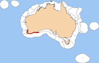
The Southwest Shelf Province, also known as the Leeuwin marine ecoregion, is a biogeographic region of Australia's continental shelf. It includes the temperate coastal waters of Southwest Australia.

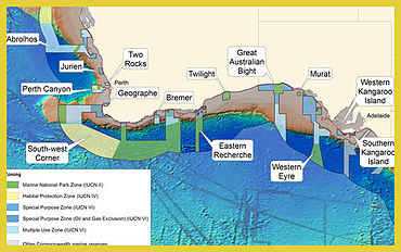
Western Kangaroo Island Marine Park is a marine protected area located south of South Australia in waters within the Australian Exclusive economic zone to the south-west of Kangaroo Island and ranging in depth from 15 metres to 165 metres.
Southern Kangaroo Island Marine Park is a marine protected area located south of South Australia in waters within the Australian Exclusive economic zone to the south of Kangaroo Island and ranging in depth from 15 metres to 100 metres.
The Coral Sea Marine Park is an Australian marine park located in the Coral Sea off the coast of Queensland. The marine park covers an area of 989,836 km2 (382,178 sq mi) and is assigned IUCN category IV. It is Australia's largest single marine park and together with the French Natural Park of the Coral Sea form the largest protected area in the World.
The Norfolk Marine Park is an Australian marine park located in the waters immediately offshore of Norfolk Island, an external territory of Australia. The marine park extends 700 km (430 mi) in a north–south direction and covers an area of 188,444 km2 (72,759 sq mi). The park is assigned IUCN category IV and is one of 8 parks managed under the Temperate East Marine Parks Network.
The Lord Howe Marine Park is an Australian marine park located about 550 km (340 mi) offshore of New South Wales, near Lord Howe Island. The marine park covers an area of 110,126 km2 (42,520 sq mi), encompassing the smaller Lord Howe Island Marine Park, and is assigned IUCN category IV. It is one of 8 parks managed under the Temperate East Marine Parks Network.
The Central Eastern Marine Park is an Australian marine park that extends from the edge of the continental shelf, offshore of New South Wales and 30 km (19 mi) from Coffs Harbour, to about 200 km (120 mi) offshore into deep ocean waters. It incorporates the waters above most of the southern portion of the Tasmantid Seamount Chain. The marine park covers an area of 70,054 km2 (27,048 sq mi) and is assigned IUCN category IV. It is one of 8 parks managed under the Temperate East Marine Parks Network.
The West Cape York Marine Park is an Australian marine park offshore of Queensland and to the west of the Cape York Peninsula. The marine park covers an area of 16,012 km2 (6,182 sq mi) and is assigned IUCN category IV. It is one of 8 parks managed under the North Marine Parks Network.
The Gulf of Carpentaria Marine Park is an Australian marine park in the Gulf of Carpentaria, offshore of Queensland and north of Mornington Island. The marine park covers an area of 23,771 km2 (9,178 sq mi) and is assigned IUCN category VI. It is one of 8 parks managed under the North Marine Parks Network.
The Oceanic Shoals Marine Park is an Australian marine park offshore of the Northern Territory, near of Darwin. The marine park covers an area of 71,743 km2 (27,700 sq mi) and is assigned IUCN category VI. It is the largest of the 8 parks managed under the North Marine Parks Network.
The Gascoyne Marine Park is an Australian marine park offshore of Western Australia, west of the Cape Range Peninsula. The marine park covers an area of 81,766 km2 (31,570 sq mi) and shares its far eastern boundary with the Ningaloo Marine Park. The park is assigned IUCN category IV and is one of the 13 parks managed under the North-west Marine Parks Network.
The Dampier Marine Park is an Australian marine park offshore of Western Australia, north-east of Karratha. The marine park covers an area of 1,252 km2 (483 sq mi) and is assigned IUCN category VI. It is one of the 13 parks managed under the North-west Marine Parks Network.

The Argo-Rowley Terrace Marine Park is an Australian marine park offshore of Western Australia. It encompasses the protected areas of the Rowley Shoals, about 260 km (160 mi) north-west of Broome. The marine park covers an area of 146,003 km2 (56,372 sq mi) and is assigned IUCN management category VI. It is the largest of the 13 parks managed under the North-west Marine Parks Network.
The Kimberley Marine Park, formerly known as the Kimberley Commonwealth Marine Reserve and also known as the Great Kimberley Marine Park, is an Australian marine park offshore of Western Australia, near the Kimberley region. Proclaimed under the EPBC Act in 2013, the marine park covers an area of 74,469 km2 (28,753 sq mi) and is assigned IUCN category VI. It is one of the 13 parks managed under the North-west Marine Parks Network. It covers a number of state-managed marine parks.

The marine ecoregions of the South African exclusive economic zone are a set of geographically delineated regions of similar ecological characteristics on a fairly broad scale, covering the exclusive economic zone along the South African coast.
The Cartier Island Marine Park is an Australian marine park that covers the Cartier Island and reef surrounds, about 610 km (380 mi) north of Broome, Western Australia. The marine park covers an area of 172 km2 (66 sq mi) and is assigned IUCN category Ia. It is one of the 13 parks managed under the North-west Marine Parks Network.
The Cod Grounds Marine Park is an Australian marine park located approximately 5.5 km offshore of New South Wales, near Laurieton. The marine park covers an area of 4 km2 (1.5 sq mi) and is assigned IUCN category II. It is one of 8 parks managed under the Temperate East Marine Parks Network.

The Mermaid Reef Marine Park is an Australian marine park in the Rowley Shoals, located approximately 280 kilometres (170 mi) north-west of Broome, Western Australia. The marine park covers an area of 540 km2 (210 sq mi) and is assigned IUCN category II. It is one of 13 parks managed under the North-west Marine Parks Network, and lies adjacent to the Argo-Rowley Terrace Marine Park

The Ashmore Reef Marine Park is an Australian marine park that covers the Ashmore Reef, which is located about 630 km (390 mi) north of Broome and 110 km (68 mi) south of the Indonesian island of Rote. The marine park covers an area of 583 km2 (225 sq mi) and is assigned IUCN category Ia. It is one of 13 parks managed under the North-west Marine Parks Network.

The Ningaloo Marine Park is an Australian marine park offshore of Western Australia, and west of the Ningaloo Coast. The marine park covers an area of 2,435 km2 (940 sq mi) and is assigned IUCN category IV. It is one of the 13 parks managed under the North-west Marine Parks Network.