Huon Commonwealth Marine Reserve is a 9,991 km2 marine protected area within Australian waters. The former Tasmanian Seamounts Marine Reserve created in 1999 was incorporated into the Huon reserve in 2007, and is part of the South-east Commonwealth Marine Reserve Network.
Freycinet Commonwealth Marine Reserve is a 57,942 km2 marine protected area within Australian waters located off the east coast of Tasmania. It extends to the outer limits of the Australian exclusive economic zone in the Tasman Sea. The reserve was established in 2007 and is part of the South-east Commonwealth Marine Reserve Network. It is the largest reserve of the South-east Network, the area covered is approximately equivalent to about 86% of the land area of Tasmania.
Flinders Commonwealth Marine Reserve is a 27,043km2 marine protected area within Australian waters located off the coast of north-east Tasmania. It extends to the outer limits of the Australian exclusive economic zone in the Tasman Sea. The reserve was established in 2007 and is part of the South-east Commonwealth Marine Reserve Network.

Australian marine parks are marine protected areas located within Australian waters and are managed by the Australian government. These waters generally extend from three nautical miles off the coast to the outer limit of Australia’s Exclusive Economic Zone at 200 nautical miles while marine protected areas located closer in-shore are the responsibility of the states or the Northern Territory.
The Norfolk Marine Park is an Australian marine park located in the waters immediately offshore of Norfolk Island, an external territory of Australia. The marine park extends 700 km (430 mi) in a north–south direction and covers an area of 188,444 km2 (72,759 sq mi). The park is assigned IUCN category IV and is one of 8 parks managed under the Temperate East Marine Parks Network.
The Lord Howe Marine Park is an Australian marine park located about 550 km (340 mi) offshore of New South Wales, near Lord Howe Island. The marine park covers an area of 110,126 km2 (42,520 sq mi), encompassing the smaller Lord Howe Island Marine Park, and is assigned IUCN category IV. It is one of 8 parks managed under the Temperate East Marine Parks Network.
The Central Eastern Marine Park is an Australian marine park that extends from the edge of the continental shelf, offshore of New South Wales and 30 km (19 mi) from Coffs Harbour, to about 200 km (120 mi) offshore into deep ocean waters. It incorporates the waters above most of the southern portion of the Tasmantid Seamount Chain. The marine park covers an area of 70,054 km2 (27,048 sq mi) and is assigned IUCN category IV. It is one of 8 parks managed under the Temperate East Marine Parks Network.
The Gulf of Carpentaria Marine Park is an Australian marine park in the Gulf of Carpentaria, offshore of Queensland and north of Mornington Island. The marine park covers an area of 23,771 km2 (9,178 sq mi) and is assigned IUCN category VI. It is one of 8 parks managed under the North Marine Parks Network.
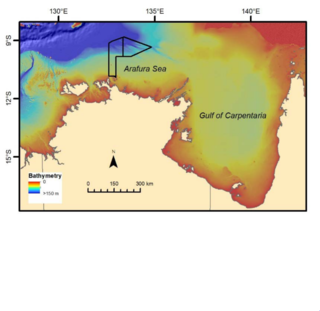
The Arafura Marine Park, about 250 km (160 mi) north-east of Darwin, is Australia's most northern marine park, and is part of the North Network of Australian Marine Parks. The Aboriginal clans of Mandilarri-Ildugij, the Mangalara, the Murran, the Gadura-Minaga and the Ngaynjaharr whose sea country this is, share some of the responsibilities for the park.
The Kimberley Marine Park, formerly known as the Kimberley Commonwealth Marine Reserve and also known as the Great Kimberley Marine Park, is an Australian marine park offshore of Western Australia, near the Kimberley region. Proclaimed under the EPBC Act in 2013, the marine park covers an area of 74,469 km2 (28,753 sq mi) and is assigned IUCN category VI. It is one of the 13 parks managed under the North-west Marine Parks Network. It covers a number of state-managed marine parks.

Eastern Recherche Marine Park is a marine park adjacent to the Recherche Archipelago, close to the Western Australian Cape Arid National Park, and 135 km east of Esperance, on the south coast of Western Australia. It has consists of two sections: one of 5,010 km2 (1,930 sq mi) which is managed as an IUCN protected area category VI, and a further section of 15,565 km2 (6,010 sq mi) which is managed as an IUCN protected area category II. The maximum depth of the park is 6,000 metres (20,000 ft).
The Macquarie Island Marine Park is an Australian marine park near Macquarie Island in the southwest Pacific. The marine park covers an area of 162,000 km2 (63,000 sq mi) and is assigned IUCN category IV. It is the largest of the 14 parks managed under the South-east Marine Parks Network.

Southern Kangaroo Island Marine Park is a marine protected area in the Australian state of South Australia located in state coastal waters adjoining both the south coast of Kangaroo Island and a group of islets located to the south of Kangaroo Island.

Western Kangaroo Island Marine Park is a marine protected area in the Australian state of South Australia located in the state’s coastal waters adjoining both the west coast of Kangaroo Island and Lipson Reef, an islet located to the south of Kangaroo Island.
The Cod Grounds Marine Park is an Australian marine park located approximately 5.5 km offshore of New South Wales, near Laurieton. The marine park covers an area of 4 km2 (1.5 sq mi) and is assigned IUCN category II. It is one of 8 parks managed under the Temperate East Marine Parks Network.
The marine protected areas of South Africa are in an area of coastline or ocean within the exclusive economic zone (EEZ) of the Republic of South Africa that is protected in terms of specific legislation for the benefit of the environment and the people who live in and use it. An MPA is a place where marine life can thrive under less pressure than unprotected areas. They are like underwater parks, and this healthy environment can benefit neighbouring areas.
The Southeast Atlantic Seamounts Marine Protected Area is an offshore conservation region in the exclusive economic zone of South Africa
The Southwest Indian Seamount Marine Protected Area is an offshore conservation region in the exclusive economic zone of South Africa.

The Lord Howe Seamount Chain of which Gifford Guyot is an eruptive centre, and part of a pair of coral-capped guyots, formed during the Miocene.. The Gifford Marine Park is co-located off the Queensland coast near Brisbane.


