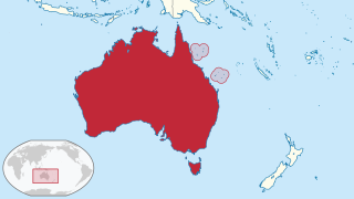
The Coral Sea Islands Territory is an external territory of Australia which comprises a group of small and mostly uninhabited tropical islands and reefs in the Coral Sea, north-east of Queensland, Australia. The only inhabited island is Willis Island. The territory covers 780,000 km2 (301,160 sq mi), most of which is ocean, extending east and south from the outer edge of the Great Barrier Reef and includes Heralds Beacon Island, Osprey Reef, the Willis Group and fifteen other reef/island groups. Cato Island is the highest point in the Territory.
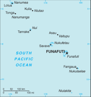
The Western Pacific nation of Tuvalu, formerly known as the Ellice Islands, is situated 4,000 kilometers (2,500 mi) northeast of Australia and is approximately halfway between Hawaii and Australia. It lies east-northeast of the Santa Cruz Islands, southeast of Nauru, south of Kiribati, west of Tokelau, northwest of Samoa and Wallis and Futuna and north of Fiji. It is a very small island country of 26 km2 (10 sq mi). Due to the spread out islands it has the 38th largest Exclusive Economic Zone of 749,790 km2 (289,500 sq mi).
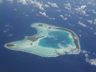
An atoll is a ring-shaped island, including a coral rim that encircles a lagoon partially or completely. There may be coral islands or cays on the rim. Atolls are located in warm tropical or subtropical oceans and seas where corals can grow. Most of the approximately 440 atolls in the world are in the Pacific Ocean.

The Maldives are formed by 20 natural atolls, along with a few islands and isolated reefs today which form a pattern stretching from 7 degrees 10′ North to 0 degrees 45′ South. The largest of these atolls is Boduthiladhunmathi, while the atoll containing the most islands is Huvadhu.
Cosmoledo Atoll is an atoll of the Aldabra Group and belongs to the Outer Islands of the Seychelles, and is located 1,029 km (639 mi) southwest of the capital, Victoria, on Mahé Island.
Pulau Hantu is located to the south of the main island of Singapore, off the Straits of Singapore. Pulau Hantu is actually made up of two islets: Pulau Hantu Besar and Pulau Hantu Kechil, with a total area of 12.6 hectares. At low tide, it is possible to wade across the shallow lagoon between the two islands, but not at high tide.
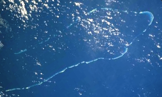
Lihou Reef National Nature Reserve is a former marine protected area covering an area of 8440 km2 in the Australian Coral Sea Islands Territory that was incorporated into the new Coral Sea Commonwealth Marine Reserve in December 2012. Together with the Coringa-Herald National Nature Reserve, from which it is separated by about 100 km of open ocean, it forms the Coral Sea Reserves Ramsar Site, designated on 16 August 2002, listing it under the Ramsar Convention as a wetland of international importance.

Kayangel (Ngcheangel) is the northernmost state of Palau 24 km (15 mi) north of Koror. The land area is about 1.4 km2 (0.54 sq mi). The population is 54.

Okinotorishima, or Parece Vela, is a coral reef with two rocks enlarged with tetrapod-cement structures. It is administered by Japan with a total shoal area of 8,482 m2 and land area 9.44 m2 (101.6 sq ft). Its dry land area is mostly made up by three concrete encasings and there is a 100 by 50 m stilt platform in the lagoon housing a research station. There is a third completely artificial tetrapod-cement islet. It is located on the Palau–Kyushu Ridge in the Philippine Sea, 534 km (332 mi) southeast of Okidaitōjima and 567 km (352 mi) west-southwest of South Iwo Jima in the Bonin Islands or 1,740 km (1,080 mi) south of Tokyo, Japan. The atoll is the southernmost part of Japan and the only Japanese territory south of the Tropic of Cancer.

Scott and Seringapatam Reefs is a group of atoll-like reefs in the Timor Sea more than 300 kilometres (190 mi) northwest of Cape Leveque, Western Australia, on the edge of the continental shelf. There are three or four separate reef structures, depending on whether Scott Reef Central is counted separately.

The Chesterfield Islands are a French archipelago of New Caledonia located in the Coral Sea, 550 km (300 nmi) northwest of Grande Terre, the main island of New Caledonia. The archipelago is 120 km long and 70 km broad, made up of 11 uninhabited islets and many reefs. The land area of the islands is less than 10 km2.
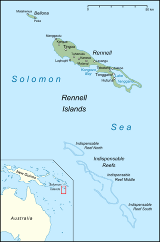
The Indispensable Reefs are a chain of three large coral atolls in the Coral Sea. They are located about 50 km (30 mi) south of Rennell Island, separated from it by Rennel Trough. The chain stretches over a length of 114 km (71 mi) and its average width is 18 km (11 mi).

Funafuti is the capital of the island nation of Tuvalu. It has a population of 6,320 people, and so it has more people than the rest of Tuvalu combined, with approximately 60% of the population. It consists of a narrow sweep of land between 20 and 400 metres wide, encircling a large lagoon 18 km long and 14 km wide. The average depth of the Funafuti lagoon is about 20 fathoms. With a surface area of 275 square kilometres (106.2 sq mi), it is by far the largest lagoon in Tuvalu. The land area of the 33 islets around the atoll of Funafuti totals 2.4 square kilometres (0.9 sq mi); taken together, they constitute less than one percent of the total area of the atoll. Cargo ships can enter Funafuti's lagoon and dock at the port facilities on Fongafale.
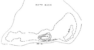
Cato Reef, a part of Cato Bank, is a coral reef in the Coral Sea, off the central coast of Queensland, Australia.

The Tizard Bank, 10°15′N114°30′E is a partially sunken atoll and one of the significant maritime features of the north-western part of the Spratly Islands. It is claimed by the People's Republic of China, the Republic of China, and Vietnam, and various parts of it are occupied by these states.

The Argo-Rowley Terrace Marine Park is an Australian marine park offshore of Western Australia. It encompasses the protected areas of the Rowley Shoals, about 260 km (160 mi) north-west of Broome. The marine park covers an area of 146,003 km2 (56,372 sq mi) and is assigned IUCN management category VI. It is the largest of the 13 parks managed under the North-west Marine Parks Network.

The Mermaid Reef Marine Park is an Australian marine park in the Rowley Shoals, located approximately 280 kilometres (170 mi) north-west of Broome, Western Australia. The marine park covers an area of 540 km2 (210 sq mi) and is assigned IUCN category II. It is one of 13 parks managed under the North-west Marine Parks Network, and lies adjacent to the Argo-Rowley Terrace Marine Park

The coral reefs of Tuvalu consist of three reef islands and six atolls, containing approximately 710 km2 (270 sq mi) of reef platforms. The islands of the Tuvalu archipelago are spread out between the latitude of 5° to 10° south and longitude of 176° to 180°, west of the International Date Line. The islands of Tuvalu are volcanic in origin. On the atolls, an annular reef rim surrounds the lagoon, and may include natural reef channels. The reef islands have a different structure to the atolls, and are described as reef platforms as they are smaller tabular reef platforms that do not have a salt-water lagoon, although they may have a completely closed rim of dry land, with the remnants of a lagoon that has no direct connection to the open sea or that may be drying up.

The Coral reefs of the Solomon Islands consists of six major islands and over 986 smaller islands, in Oceania, to the east of Papua New Guinea and northwest of Vanuatu. The Solomon Islands lie between latitudes 5° and 13°S, and longitudes 155° and 169°E. The distance between the westernmost and easternmost islands is about 1,500 km (930 mi). The Santa Cruz Islands are situated north of Vanuatu and are especially isolated at more than 200 km (120 mi) from the other islands. The Solomon Islands has the 22nd largest Exclusive Economic Zone of 1,589,477 km2 (613,701 sq mi) of the Pacific Ocean.


