
Davis County is a county in northern Utah, United States. As of the 2020 United States Census, the population was 362,679, making it Utah's third-most populous county. Its county seat is Farmington, and its largest city by both population and area is Layton.

Sanpete County is a county in the U.S. state of Utah. As of the 2020 United States Census, the population was 28,437. Its county seat is Manti, and its largest city is Ephraim. The county was created in 1850.

Wasatch County is a county in the U.S. state of Utah. As of the 2020 United States Census, the population was 34,788. Its county seat and largest city is Heber City. The county was named for a Ute word meaning "mountain pass" or "low place in the high mountains".

Clearfield is a city in Davis County, Utah, United States. The population was 31,909 at the 2020 census. The city grew rapidly during the 1940s, with the formation of Hill Air Force Base, and in the 1950s with the nationwide increase in suburb and "bedroom" community populations and has been steadily growing since then.

Kaysville is a city in Davis County, Utah. It is part of the Ogden–Clearfield metropolitan area. The population was 32,945 at the time of the 2020 census.
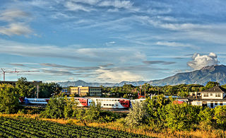
Layton (/ˈleɪʔɪn/) is a city in Davis County, Utah, United States. It is part of the Ogden-Clearfield Metropolitan Statistical Area. As of the 2020 census, the city had a population of 81,773, with 2022 Census Bureau estimates showing an increase to 82,601. 2024 estimates place Layton's population at 87,392. Layton is the most populous city in Davis County and the ninth most populous in Utah.
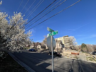
The Avenues is an affluent neighborhood in Salt Lake City, Utah. It is named after the perfectly gridlike, closely laid out roads called Avenues and Streets. First surveyed in the 1850s, the Avenues became Salt Lake City's first neighborhood. Today, the Avenues neighborhood is generally considered younger, more progressive, and somewhat "artsy" when compared to other neighborhoods. Many young professionals choose to live there due to the culture and easy commute to downtown.. It is also one of the most important strongholds of the Utah Democratic Party.

The Wasatch Front is a major metropolitan region in the north-central part of the U.S. state of Utah. It consists of a chain of mostly contiguous cities and towns stretched along the Wasatch Range from Santaquin in the south to Pleasant View in the north, and containing the cities of Salt Lake City, Provo, Orem, Bountiful, Layton, and Ogden.
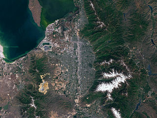
Salt Lake Valley is a 500-square-mile (1,300 km2) valley in Salt Lake County in the north-central portion of the U.S. state of Utah. It contains Salt Lake City and many of its suburbs, notably Murray, Sandy, South Jordan, West Jordan, and West Valley City; its total population is 1,029,655 as of 2010. Brigham Young said, "this is the right place," when he and his fellow Mormon settlers moved into Utah after being driven out of several states.
The Wasatch Back is a region in the Rocky Mountains in northern Utah, United States. It includes cities such as Park City, Heber City, and Morgan. The name Wasatch Back differentiates it from the Wasatch Front, which includes Utah's more populous cities such as Salt Lake City, Ogden, Layton, and Provo. The Wasatch Back sits on the eastern side of the Wasatch Range of the Rocky Mountains, while the Wasatch Front sits on the western side. Wasatch is a Ute Indian word that means "mountain pass" or "low pass over high range." The Wasatch Back is a very affluent region. Summit County is one of the wealthiest counties in the United States.

Davis School District is a school district serving Davis County, Utah, United States. Headquartered in the county seat of Farmington, it is the 61st largest school district in the United States and the 2nd largest school district in Utah with 72,987 students attending Davis schools as of 2019. It is located almost entirely within Davis County. Students attend elementary school from kindergarten to 6th grade, junior high from 7th grade-9th grade, and high school from 10th grade-12th grade.

Interstate 15 (I-15) runs north–south in the U.S. state of Utah through the southwestern and central portions of the state, passing through most of the state's population centers, including St. George and those comprising the Wasatch Front: Provo–Orem, Salt Lake City, and Ogden–Clearfield. It is Utah's primary and only north–south interstate highway, as the vast majority of the state's population lives along its corridor; the Logan metropolitan area is the state's only Metropolitan Statistical Area through which I-15 does not pass. In 1998, the Utah State Legislature designated Utah's entire portion of the road as the Veterans Memorial Highway.
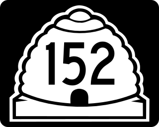
State Route 152 (SR-152) is a state highway in the suburbs of Salt Lake City, Utah connecting SR-71 in Murray to I-215 and city-maintained Highland Drive in Cottonwood Heights, though for almost all of its length it forms the border between Murray and Holladay. The route, which is 3.04 miles (4.89 km), is laid on the entire length of the Van Winkle Expressway and a portion of Highland Drive.

State Route 224 (SR-224) is a north–south state highway in the U.S. state of Utah. The route connects Interstate 80 and Kimball Junction in the north to Park City in the south. Ski resorts line the mostly four-lane highway, including Park City Resort and Deer Valley. The highway has changed paths many times since its formation in 1941, at one point connecting to Big Cottonwood Canyon and Salt Lake County. However, realignments brought the route to its present path by 1990.

Provo Canyon is located in unincorporated Utah County and Wasatch County, Utah. Provo Canyon runs between Mount Timpanogos on the north and Mount Cascade on the south. The canyon extends from Orem on the west end to Heber City on the east. Provo Canyon is situated to the east of Utah Valley and grants access to the valleys and Uinta Basin regions that lie beyond the Wasatch front.

Scofield Reservoir is a 2,815-acre (11.39 km2) reservoir impounded by Scofield Dam, in Carbon County, Utah. Located on the Price River, a tributary of the Green River, Scofield Reservoir is adjacent to the northernmost boundary of the Manti–La Sal National Forest. The reservoir sits at an elevation of 7,618 feet (2,322 m), on the northern edge of the Wasatch Plateau. Utah State Route 96 runs along the western shoreline.

Independence is a town in Wasatch County, Utah, United States. Lying just east of U.S. Route 40 southeast of Heber City, Independence was incorporated in 2008 under a controversial, short-lived state law. The population was 164 at the 2010 census.

Big Cottonwood Creek is located in the Wasatch Mountains just east of Salt Lake City. It is part of the Big Cottonwood Creek Watershed, which ranges in elevation from 5,000 to 10,500 feet with the headwaters around 9,600 feet. The creek flows through the Big Cottonwood Canyon in a westerly direction until it emerges into Salt Lake Valley about eighteen miles (29 km) from its highest source. Thence its course is northwesterly through Cottonwood Heights, Holladay, and Murray, Utah for a little over twenty-four miles from the headwaters until it empties into the Jordan River about five miles (8.0 km) south of Salt Lake City. The water eventually flows into the Great Salt Lake. In the summer, its waters are all used for irrigation purposes. From its source to its original outlet in the Jordan River is about twenty-six miles.

Interlaken is a town in northwestern Wasatch County, Utah, United States. The population was 179 at the 2020 census.


