
Northumberland is a ceremonial county in North East England, bordering Scotland. It is bordered by the Scottish Borders to the north, the North Sea to the east, Tyne and Wear and County Durham to the south, and Cumbria to the west. The town of Blyth is the largest settlement. Northumberland is the northernmost county in England.

Berwick-upon-Tweed, sometimes known as Berwick-on-Tweed or simply Berwick, is a town and civil parish in Northumberland, England, 2.5 mi (4 km) south of the Anglo-Scottish border, and the northernmost town in England. The 2011 United Kingdom census recorded Berwick's population as 12,043.

Peel towers are small fortified keeps or tower houses, built along the English and Scottish borders in the Scottish Marches and North of England, mainly between the mid-14th century and about 1600. They were free-standing with defence being a prime consideration in their design, although "confirmation of status and prestige" also played a role. Additionally, they functioned as watch-towers, where garrisoned personnel could light signal fires to warn of approaching danger.

Belford is a village and civil parish in Northumberland, England, about halfway between Alnwick and Berwick-upon-Tweed, a few miles inland from the east coast and just off the Great North Road, the A1. At the 2001 census it had a population of 1,055, increasing to 1,258 at the 2011 Census.

Prudhoe is a town and civil parish in the south of Northumberland, England. It is 11 miles (18 km) west of Newcastle upon Tyne and situated on a steep, north-facing hill on the south bank of the River Tyne. Prudhoe had a population of 11,675 at the 2011 census, making it the second largest town in the Tyne Valley after Hexham.
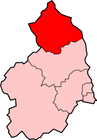
Berwick-upon-Tweed was a local government district and borough in Northumberland in the north-east of England, on the border with Scotland. The district had a resident population of 25,949 according to the 2001 census, which also notes that it is the most ethnically homogeneous in the country, with 99.6% of the population recording themselves in the 2001 census as White. It was also the least populated district in England with borough status, and the third-least densely populated local government district.

Cramlington is a town and civil parish in Northumberland. It is 6 miles north of Newcastle upon Tyne. The name suggests a probable founding by the Danes or Anglo-Saxons.
Sedgley is a town in the north of the Dudley district, in the county of the West Midlands, England.

Monkseaton is an area of Whitley Bay, North Tyneside, in the county of Tyne and Wear, England. Historically in Northumberland, it is in the north-east of the borough, 3⁄4 mile from the North Sea coast and 1+1⁄2 mi (2.5 km) north of the River Tyne at North Shields. One mile to the north of Monkseaton, the extensive built-up areas of North Tyneside change abruptly into green belt stretching north into south-east Northumberland. It is at an elevation of 130 feet (40 m) above sea-level.

Fenham is an area of the west-end of Newcastle upon Tyne, in the county of Tyne and Wear, England. It lies to the west of the city centre, and is bounded on the north and east by a large area of open land known as the Town Moor. To the south lies Benwell, West Denton lies to the west, Blakelaw and Cowgate to the north, and Arthur's Hill and Spital Tongues to the east. Until 1974 it was in Northumberland.

Akeld is a village and civil parish in Northumberland, England. It is situated around 2.7 miles (4.3 km) to the west of Wooler and 9.3 miles (15.0 km) from the border with Scotland at Coldstream. The village lies on the northern limit of Northumberland National Park and on the foot of the Cheviot Hills massif. It is overlooked by Akeld Hill and Harehope Hill to the south. In 2001 Akeld had a population of 82, increasing at the 2011 Census to 221, although this was partly due to the parish merging with that of Kirknewton. The burn which runs through the village and down to the Milfield Basin also bears the name Akeld.

Cornhill-on-Tweed is a small village and civil parish in Northumberland, England about 1 mile (1.6 km) to the east of Coldstream, Scotland. The hamlets of West Learmouth and East Learmouth are located to the south and west of the village respectively. In 2011 the parish had a population of 347.
Mitford is a village in Northumberland, England, located two miles west of Morpeth.

Shiremoor is a village in Tyne and Wear, Northern England. It is in the Metropolitan Borough of North Tyneside and formerly governed under Northumberland. In the 2011 census, it was included in the Tynemouth area of Tyneside. It is near the North East Green Belt, which surrounds Tyneside, Wearside and Durham. It is located around 3+1⁄2 miles from Whitley Bay.
Swarland is a small modern village and former civil parish, now in the parish of Newton-on-the-Moor and Swarland, in the county of Northumberland, England, situated about 7 miles (11 km) south of the market town of Alnwick and 25 miles (40 km) north of the city of Newcastle upon Tyne. In 1951 the parish had a population of 368.

Ashington is a town and civil parish in Northumberland, England, with a population of 27,864 at the 2011 Census. It was once a centre of the coal mining industry. The town is 15 miles (24 km) north of Newcastle upon Tyne, west of the A189 and bordered to the south by the River Wansbeck. Many inhabitants have a distinctive accent and dialect known as Pitmatic. This varies from the regional dialect known as Geordie.

Longframlington is a small village in Northumberland, England, located on the A697, 11 miles (18 km) north-west of Morpeth and 5 miles (8 km) south-east of Rothbury. Longframlington is a former pit village and on the site of the pit now stands Fram Park, a log cabin holiday park. The village was previously the site of the Longframlington Music Festival.
Middle Ord is a small hamlet, between West Ord and East Ord, and west of the town of Berwick upon Tweed, Northumberland England. The population as of March 2008, is nineteen residents within seven dwellings, centered on Middle Ord Manor House.

Scremerston is a village in Northumberland, England. The village lies on the North Sea coast just under 2.5 miles (4 km) south of Berwick-upon-Tweed and 4.3 miles (7 km) from the Anglo-Scottish border. It is adjacent to the A1, providing access to Newcastle upon Tyne to the south, and to Edinburgh to the north.

Kilham is a hamlet and civil parish in the English county of Northumberland, located 8.0 miles (12.9 km) west of Wooler, 12.0 miles (19.3 km) east of Kelso, 17.0 miles (27.4 km) south west of Berwick-upon-Tweed and 38.9 miles (62.6 km) north west of Morpeth. It lies on the northern edge of the Northumberland National Park in Bowmont Valley Northumberland. The hamlet, which consists of a small group of agricultural dwellings, is overlooked by Kilham Hill and the northern limits of the Cheviot Hills. The parish had a population of 131 in 2001, and includes the hamlets of Howtel and Pawston, along with the former upland township of Coldsmouth and Thompson's Walls. falling to less than 100 at the 2011 Census. Details are now included in the parish of Branxton

