East St. Clair Township, Pennsylvania | |
---|---|
Country | United States |
State | Pennsylvania |
County | Bedford |
Settled | 1794 |
Incorporated | 1875 |
Area | |
• Total | 34.05 sq mi (88.18 km2) |
• Land | 33.89 sq mi (87.78 km2) |
• Water | 0.15 sq mi (0.40 km2) |
Population | |
• Total | 2,908 |
2,889 | |
• Density | 86.45/sq mi (33.38/km2) |
Time zone | UTC-5 (Eastern (EST)) |
• Summer (DST) | UTC-4 (EDT) |
Area code | 814 |
FIPS code | 42-009-21788 |
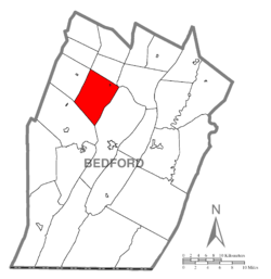
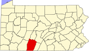
East St. Clair Township is a township in Bedford County, Pennsylvania, United States. The population was 2,908 at the 2020 census. [2]
The Osterburg Covered Bridge and Snooks Covered Bridge were listed on the National Register of Historic Places in 1980. [3]
The township is located in northwestern Bedford County. It is bordered to the north by King Township, to the northeast by South Woodbury Township, to the east by Bedford Township, to the southwest by Napier Township, to the west by West St. Clair Township, and at its northernmost point by Lincoln Township. It surrounds but does not include the borough of St. Clairsville.
According to the United States Census Bureau, the township has a total area of 34.1 square miles (88.2 km2), of which 33.9 square miles (87.8 km2) is land and 0.15 square miles (0.4 km2), or 0.45%, is water. [4]
Census | Pop. | Note | %± |
---|---|---|---|
2010 | 3,048 | — | |
2020 | 2,908 | −4.6% | |
2023 (est.) | 2,889 | [2] | −0.7% |
U.S. Decennial Census [5] |
As of the census [6] of 2000, there were 3,123 people, 1,198 households, and 894 families residing in the township. The population density was 92.3 inhabitants per square mile (35.6/km2). There were 1,406 housing units at an average density of 41.5 per square mile (16.0/km2). The racial makeup of the township was 98.43% White, 0.51% African American, 0.03% Native American, 0.67% Asian, 0.10% from other races, and 0.26% from two or more races. Hispanic or Latino of any race were 0.42% of the population.
There were 1,198 households, out of which 35.5% had children under the age of 18 living with them, 61.6% were married couples living together, 9.2% had a female householder with no husband present, and 25.3% were non-families. 22.0% of all households were made up of individuals, and 8.3% had someone living alone who was 65 years of age or older. The average household size was 2.61 and the average family size was 3.04.
In the township the population was spread out, with 26.0% under the age of 18, 8.1% from 18 to 24, 30.8% from 25 to 44, 22.4% from 45 to 64, and 12.6% who were 65 years of age or older. The median age was 36 years. For every 100 females there were 102.0 males. For every 100 females age 18 and over, there were 98.3 males.
The median income for a household in the township was $34,847, and the median income for a family was $38,429. Males had a median income of $28,776 versus $20,170 for females. The per capita income for the township was $16,211. About 6.6% of families and 8.4% of the population were below the poverty line, including 9.4% of those under age 18 and 9.0% of those age 65 or over.
China Township is a charter township of St. Clair County in the U.S. state of Michigan. The population was 3,509 at the 2020 Census. It is named after China, Maine.
Bedford Township is a township in Bedford County, Pennsylvania, United States. The population was 5,103 at the 2020 census.
Broad Top Township is a township in Bedford County, Pennsylvania, United States. The population was 1,440 at the 2020 census.
East Providence Township is a township in Bedford County, Pennsylvania, United States. The population was 1,800 at the 2020 census. The unincorporated community of Breezewood is in the township, which holds the Township's municipal buildings.
Harrison Township is a township in Bedford County, Pennsylvania, United States. The population was 933 at the 2020 census.
Hopewell Township is a township in Bedford County, Pennsylvania, United States. The population was 1,890 at the 2020 census.
Kimmel Township is a township that is located in Bedford County, Pennsylvania, United States. The population was 1,527 at the time of the 2020 census.
Liberty Township is a township in Bedford County, Pennsylvania, United States. The population was 1,383 at the 2020 census. Warriors Path State Park is located in the township.
Londonderry Township is a township in Bedford County, Pennsylvania, United States. It is named after County Londonderry, now in Northern Ireland. The population was 1,641 at the 2020 census.
Monroe Township is a township in Bedford County, Pennsylvania, United States. The population was 1,398 at the 2020 census.
Napier Township is a township in Bedford County, Pennsylvania, United States. The population was 2,031 at the 2020 census.
South Woodbury Township is a township in Bedford County, Pennsylvania, United States. The population was 2,082 at the 2020 census.
St. Clairsville is a borough in Bedford County, Pennsylvania, United States. The population was 76 at the 2020 census.
West Providence Township is a township in Bedford County, Pennsylvania, United States. The population was 3,078 at the 2020 census.
West St. Clair Township is a township that is located in Bedford County, Pennsylvania, United States. The population was 1,647 at the time of the 2020 census.
Woodbury Township is a township that is located in Bedford County, Pennsylvania, United States. As of the 2020 census, the population was 1,181.
Davidsville is a census-designated place (CDP) in Somerset County, Pennsylvania, United States. The population was 1,119 at the 2000 census. It is part of the Johnstown, Pennsylvania, Metropolitan Statistical Area. Davidsville is part of the municipality of Conemaugh Township, Somerset County, Pennsylvania, as are the nearby towns of Jerome, Thomas Mills, Tire Hill, Seanor, Hyasota, and part of Holsopple. Davidsville is Area code: 814 Exchange: 479; ZIP Code: 15928.
Ogle Township is a township in Somerset County, Pennsylvania, United States. The population was 467 at the 2020 census. It is part of the Johnstown, Pennsylvania, Metropolitan Statistical Area.
Fairfield Township is a township in Westmoreland County, Pennsylvania, United States. The population was 2,051 at the 2020 census.
St. Clair Township is a township in Westmoreland County, Pennsylvania, United States. The population was 1,339 at the 2020 census. It is also one of three communities within the county to utilise the 814 area code, alongside New Florence and Seward.