El Paso, La Palma

Last updated

El Paso
Bandera de El Paso.svg
Escudo de El Paso.svg
El Paso map.jpg
Canarias-loc.svg
Red pog.svg
El Paso
Location in Canary Islands
Coordinates: 28°39′N17°53′W / 28.650°N 17.883°W / 28.650; -17.883
CountrySpain
Autonomous community Canary Islands
Province Santa Cruz de Tenerife
Island La Palma
Area
[1]
  Total135.92 km2 (52.48 sq mi)
Population
 (2018) [2]
  Total7,543
  Density55/km2 (140/sq mi)

El Paso, also known as Ciudad de El Paso, is a Spanish municipality located on the island of La Palma, province of Santa Cruz de Tenerife, Canary Islands.

Contents

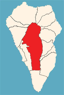
Geographically it is located in the center of the island of La Palma, covering to the west with the Caldera de Taburiente, part of the Aridane Valley, the Cumbre Nueva and the Cumbre Vieja. It is on the surface the largest municipality of the island, being the only one of the 14 municipalities of La Palma that lacks coastal strip. In 2016 it had a population of 7457 inhabitants. [3]

The nucleus of population had to have its origins in the pre-Hispanic stage of the island. Almost certainly, because of the engravings found in the area, it consisted of a first moment in a temporary settlement of Benahoarite shepherds. [4] During the colonization and almost throughout the Modern Age the present territory of the municipality was administratively part of the Aridane Valley. In 1837, under the reign of Alfonso XII, the municipality obtained the title of City, segregating of the Los Llanos de Aridane. [5]

At the summit of the municipality is the oldest canarian pine in the world, with an estimated age of more than 1000 years. [6]

History

Volcano Cumbre Vieja on 21 October 2021 Vulcano 2021-10-21 seen from El Paso.jpg
Volcano Cumbre Vieja on 21 October 2021

Many footpaths already crisscrossed La Palma before the Spanish conquest. A number of mountain passes east of present-day El Paso enabled cross-island communications. One of these was Ajerjo Pass by which the island's Spanish discoverer, Alonso Fernandez de Lugo, attempted to enter the Caldera de Taburiente, hence its local name the Captain's Pass (Paso del Capitán). The village of El Paso was named after this mountain pass by association. [7]

On 3 May 1492 the mentioned Fernandez de Lugo finishes the conquest of the island of La Palma by the Spanish when conquering the last remaining stronghold of the native Guanches, the kingdom of Aceró. To this goal, Fernandez deceitfully invited its king Tanausú to an interview, to have him imprisoned on appearance. The island was made directly subject to the Spanish Crown, a situation which would last until 1812. In this year the new Spanish Constitution paved the way for decentralisation of the Canary Islands and subdivision into municipalities. [8]

At about 15:15 local time on Sunday 19 September 2021 the volcano above the town erupted following multiple tremors. It is situated in the Cumbre Vieja national park, despite having been quiet since 1971. [9]

Historical population

Historical population of El Paso, La Palma
Year20062007200820092010201120122013201420152016
Population7,5057,5147,8157,8157,8377,9477,8747,9287,6147,5637,457

Administration and policy

The local administration of the municipality is carried out through the City Council of El Paso, whose components are elected every four years by universal suffrage of all Spanish citizens and the European Union over 18 years of age who are registered in the municipality. According to the provisions of the General Electoral Regime Law, which establishes the number of eligible councilors depending on the population of the municipality, the Municipal Corporation of El Paso is formed by 13 councilors. The city council has mayor-president and twelve more councilors. In the elections of May 24, 2015 obtained a simple majority Canary Coalition, forming a coalition government with PSOE. The current government team is composed of the mayor-president, four mayors and three councilors.

List of mayors since the 1979 democratic elections:

Mayor StartEndPolitical Party
Miguel Ángel Hernández Martín19791983 Union de Centro Democratico (logo).svg Unión de Centro Democrático (UCD)
Miguel Ángel Hernández Martín19831983 Bandera de El Paso.svg Grupo Electoral Libre de El Paso
Francisco Sánchez Pérez19831987 Bandera de El Paso.svg Grupo Electoral Libre de El Paso
Francisco Sánchez Pérez19871991Agrupación Palmera de Independientes (API)
Francisco Sánchez Pérez19911995Agrupación Palmera de Independientes (API)
Ángel Raúl Rodríguez Pages19951999 Logotipo del PSOE.svg Partido Socialista Obrero Español (PSOE)
Francisco Sánchez Pérez19992000 Logocoalicion.svg Coalición Canaria (CC)
Higinio Máximo Brito20002003 Logocoalicion.svg Coalición Canaria (CC)
Jesús Manuel Rodríguez20032007 People's Party (Spain) Logo.svg Partido Popular (PP)
María Dolores Padilla Felipe20072009 Logotipo del PSOE.svg Partido Socialista Obrero Español (PSOE)
Higinio Máximo Brito20092011 Logocoalicion.svg Coalición Canaria (CC)
María Dolores Padilla Felipe20112015 Logotipo del PSOE.svg Partido Socialista Obrero Español (PSOE)
Sergio Javier Rodríguez Fernández2015- Logocoalicion.svg Coalición Canaria (CC)

See also

Related Research Articles

<span class="mw-page-title-main">Canary Islands</span> Spanish archipelago and region in the Atlantic Ocean

The Canary Islands, also known informally as the Canaries, are a Spanish autonomous community and archipelago in Macaronesia in the Atlantic Ocean. At their closest point to the African mainland, they are 100 kilometres west of Morocco and the Western Sahara. The Canary Islands are part of Spanish Africa. They are the southernmost of the autonomous communities of Spain. The islands have a population of 2.2 million people and are the most populous special territory of the European Union.

<span class="mw-page-title-main">Province of Santa Cruz de Tenerife</span> Province of Spain

Province of Santa Cruz de Tenerife, also Province of Santa Cruz, is a province of Spain, consisting of the western part of the autonomous community of the Canary Islands. It consists of about half of the Atlantic archipelago: the islands of Tenerife, La Gomera, El Hierro, and La Palma. It occupies an area of 3,381 km2 (1,305 sq mi). It also includes a series of adjacent roques.

<span class="mw-page-title-main">La Palma</span> Most northwestern Canary Island

La Palma, also known as La isla bonita and historically San Miguel de La Palma, is the most northwesterly island of the Canary Islands, Spain. La Palma has an area of 708.32 square kilometres (273.48 sq mi) making it the fifth largest of the eight main Canary Islands. The total population at the start of 2023 was 84,338, of which 15,522 lived in the capital, Santa Cruz de La Palma and 20,375 in Los Llanos de Aridane. Its highest mountain is the Roque de los Muchachos, at 2,426 metres (7,959 ft), being second among the peaks of the Canaries after the Teide massif on Tenerife.

<span class="mw-page-title-main">Cumbre Vieja</span> Volcano in La Palma, Spain

The Cumbre Vieja is an active volcanic ridge on the island of La Palma in the Canary Islands, Spain. The spine of Cumbre Vieja trends in an approximate north–south direction, comprising the southern half of La Palma, with both summit ridge and flanks pockmarked by dozens of craters and cones. The latest eruption began on 19 September 2021 in a forested area of Las Manchas locality known as Cabeza de Vaca. Voluminous lava flows quickly reached populated areas downslope, fanning out across settlements and banana plantations, destroying thousands of buildings and ultimately pouring over steep cliffs into the ocean to enlarge the island at several locations. The volcano went quiet on 13 December 2021, and on 25 December 2021, the local government declared the eruption to be over.

<span class="mw-page-title-main">Caldera de Taburiente National Park</span> National park in the Canary Islands, Spain

Caldera de Taburiente National Park is a national park on the island of La Palma, Canary Islands, Spain. It contains the Caldera de Taburiente, which dominates the northern part of the island, and was designated as a national park in 1954. The telescopes of the Roque de los Muchachos Observatory are situated very close to the summit.

<span class="mw-page-title-main">Garafía</span> Municipality in Canary Islands, Spain

Garafía is a municipality in the island of La Palma, Santa Cruz de Tenerife. Located in the northwest of the island, in the middle od two whims of nature: the ravines of Franceses bordering Barlovento and Izcagua by the South, bordering Punta Gorda. The administrative capital, home to the City Council, is called Santo Domingo; its parish church, Iglesia de Nuestra Señora de La Luz dates back to the 16th century. Garafía has a length of 25.50 km coastline. with cliffs of incredible beauty but very steep and difficult to access, which can only be reached on foot, demanding a great effort to those not used to walking on rough terrain. Yes, their landscapes not leave anyone indifferent by the canopy of deep green vegetation that tupe those cliffs and see the ravines in contrast to the blue of the sky and its wild seas, as an example cited the gorgeous Beach Bujarén in Santo Domingo, with its roques; is the North of La Palma: a magical, unique, and unparalleled place.

<span class="mw-page-title-main">San Cristóbal de La Laguna</span> Municipality and city in Canary Islands, Spain

San Cristóbal de La Laguna is a city and municipality in the northern part of the island of Tenerife in the Province of Santa Cruz de Tenerife, on the Canary Islands, Spain. The former capital of the Canary Islands, the city is the third-most populous city of the archipelago and the second-most populous city of the island. La Laguna's historical center was declared a World Heritage Site by UNESCO in 1999. La Laguna is situated alongside the city of Santa Cruz de Tenerife; thus, the two cities and municipalities form a single large urban center. Its economy is business-oriented while agriculture dominates the northeastern portion of the city. The urban area dominates the central and the southern parts.

<span class="mw-page-title-main">Fuencaliente de La Palma</span> Municipality in Canary Islands, Spain

Fuencaliente de La Palma, also Fuencaliente, is a municipality in the southern part of the island La Palma in the province of Santa Cruz de Tenerife of the Canary Islands, Spain. The seat of the municipality is the village Los Canarios. It has been the seat since 1837. The population of the municipality is 1,798 (2013) and the area is 56.42 km².

<span class="mw-page-title-main">Santa Cruz de La Palma</span> Municipality in Canary Islands, Spain

Santa Cruz de la Palma is a city and a municipality on the east coast of the island of La Palma in the province of Santa Cruz de Tenerife of the Canary Islands. Santa Cruz de la Palma is the second-largest city and is the capital of the island. It is along an old lava flow coming from the Caldereta, a volcano just south of the city.

<span class="mw-page-title-main">Puntagorda</span> Municipality in Canary Islands, Spain

Puntagorda is a village and a municipality in the northwestern part of the island of La Palma, Canary Islands, Spain. It is situated 23 km northwest of Santa Cruz de la Palma. The municipality consists of a number of small villages, total population 2,057 (2013). The area is 31.10 km². The elevation of the village is around 700 m. The elevation of the municipality ranges from sea level to over 2000 m.

<span class="mw-page-title-main">Los Llanos de Aridane</span> City in Canary Islands, Spain

Los Llanos de Aridane is a municipality of the Province of Santa Cruz de Tenerife, Canary Islands, Spain. It is located in the west of the island of La Palma, in the Aridane Valley. With 20,930 inhabitants (2013) it is the most populous municipality of La Palma.

<span class="mw-page-title-main">Tazacorte</span> Municipality in Canary Islands, Spain

Tazacorte is a town and a municipality on the island of La Palma, Province of Tenerife, Canary Islands, Spain. It is near the coast, in the western part of the island. The population of the municipality is 4,600 (2018) and the area is 11.37 km2. The average elevation is 60 m. Tazacorte is 2 km southwest of Los Llanos de Aridane and 17 km west of the island capital Santa Cruz de La Palma. The inhabitants are known as Bagañetes.

<span class="mw-page-title-main">Alonso Fernández de Lugo</span>

Alonso Fernández de Lugo was a Spanish military man, conquistador, city founder, and administrator. He conquered the islands of La Palma (1492–1493) and Tenerife (1494–1496) for the Castilian Crown; they were the last of the Canary Islands to be conquered by Europeans. He was also the founder of the towns of San Cristóbal de La Laguna, Santa Cruz de Tenerife and Santa Cruz de La Palma. One biographer has written that his personality was a “terrible mixture of cruelty and ambition or greed, on one part, and on the other a great capacity and sense for imposing order and government on conquered lands,” a trait found in the conquistadors of the New World.

<span class="mw-page-title-main">Tanausu</span>

Tanausu was the Guanche ruler of Aceró, on the island of La Palma, whose defeat by the Castilians marked the final conquest of that island. The island of Tenerife, conquered in 1495, was the last of the Canary Islands to fall under European control. His name has been translated as "The obstinate" or "He who has kidneys."

<span class="mw-page-title-main">Roman Catholic Diocese of San Cristóbal de La Laguna</span> Catholic diocese in Spain

The Diocese of San Cristóbal de La Laguna, also called Diocese of Tenerife or Diocese Nivariense, is a diocese located in the city of San Cristóbal de La Laguna in the Canary Islands and a suffragan in the ecclesiastical province of the Archdiocese of Sevilla in Spain. The diocese includes the islands of Tenerife, La Palma, La Gomera and El Hierro, in the province of Santa Cruz de Tenerife. The bishop of this diocese is Bernardo Álvarez Afonso.

<span class="mw-page-title-main">2021 Cumbre Vieja volcanic eruption</span> Volcanic eruption in the Canary Islands, Spain

An eruption at the Cumbre Vieja volcanic ridge, comprising the southern half of the Spanish island of La Palma in the Canary Islands, took place between 19 September and 13 December 2021. It was the first volcanic eruption on the island since the eruption of Teneguía in 1971. At 85 days, it is the longest known and the most damaging volcanic eruption on La Palma since records began. The total damage caused by the volcano amounts up to 843 million euros.

<span class="mw-page-title-main">Iglesia de San Pío X (Todoque)</span> Building in Los Llanos de Aridane, Spain

The Church of Saint Pius X was a Catholic church located in Todoque, Los Llanos de Aridane, La Palma. Built in 1954 and destroyed during the 2021 Cumbre Vieja volcanic eruption, it was the world's first church dedicated to Pope Pius X.

<span class="mw-page-title-main">Todoque</span> Ghost town in Canary Islands, Spain

Todoque Is a ghost town belonging to the municipality of Los Llanos de Aridane, located in the southwest of the island of La Palma, Canary Islands. Its main neighborhoods were Todoque, Los Pasitos and Todoque de Arriba. The town was first badly damaged and many buildings destroyed by the Cumbre Vieja vulcano eruption in September 2021, which ended up engulfing it entirely.

<span class="mw-page-title-main">La Laguna (Los Llanos de Aridane)</span> Town in Canary Islands, Spain

La Laguna is a town and neighbourhood of Los Llanos de Aridane, in La Palma, Canary Islands, Spain. It was significantly affected by a lava flow from the 2021 Cumbre Vieja volcanic eruption, which destroyed hundreds of houses in the town.

References

  1. Instituto Canario de Estadística, area
  2. Municipal Register of Spain 2018. National Statistics Institute.
  3. "INEbase. CONSUL". www.ine.es (in Spanish). Archived from the original on 4 January 2017. Retrieved 27 February 2017.
  4. "Estrategias Sociales en La explotación del territorio entre los Benhaoaritas" (PDF). Archived from the original (PDF) on 26 June 2013. Retrieved 27 February 2017.
  5. "El Paso, de una 'tierna venganza' a ciudad centenaria". eldia.es (in European Spanish). 26 August 2010. Retrieved 27 February 2017.
  6. "El pino más viejo de Canarias tiene achaques". eldiario.es (in Spanish). Archived from the original on 25 August 2018. Retrieved 27 February 2017.
  7. "La Palma OutDoor " EL Paso". www.lapalmaoutdoor.com (in European Spanish). Archived from the original on 4 January 2017. Retrieved 27 February 2017.
  8. "El Paso". www.palmerosenelmundo.com (in European Spanish). Archived from the original on 28 July 2017. Retrieved 27 February 2017.
  9. BBC:Volcano on Canary Island La Palma erupts, spewing ash and lava into national park