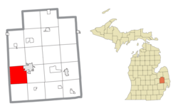
Elba Township, Lapeer County, Michigan

Last updated

Elba Township, Michigan
Elba Township, Lapeer County, Michigan location.png
Location within Lapeer County
USA Michigan location map.svg
Red pog.svg
Elba Township
Location within the state of Michigan
Usa edcp location map.svg
Red pog.svg
Elba Township
Location within the United States
Coordinates: 43°01′13″N83°24′39″W / 43.02028°N 83.41083°W / 43.02028; -83.41083
Country United States
State Michigan
County Lapeer
Area
  Total34.0 sq mi (88.1 km2)
  Land32.8 sq mi (84.9 km2)
  Water1.2 sq mi (3.1 km2)
Elevation
850 ft (259 m)
Population
 (2010)
  Total5,250
  Density160.1/sq mi (61.8/km2)
Time zone UTC-5 (Eastern (EST))
  Summer (DST) UTC-4 (EDT)
ZIP codes
48446 (Lapeer),
48455 (Metamora)
FIPS code 26-25160 [1]
GNIS feature ID1626222 [2]

Elba Township is a civil township of Lapeer County in the U.S. state of Michigan. The population was 5,250 at the 2010 Census.

Contents

History

Elba Township was established in 1838. [3]

Communities

Geography

According to the United States Census Bureau, the township has a total area of 34.0 square miles (88.1 km2), of which 32.8 square miles (84.9 km2) is land and 1.2 square miles (3.1 km2) (3.56%) is water.

Demographics

As of the census [1] of 2000, there were 5,462 people, 1,940 households, and 1,550 families residing in the township. The population density was 166.6 inhabitants per square mile (64.3/km2). There were 2,121 housing units at an average density of 64.7 per square mile (25.0/km2). The racial makeup of the township was 97.25% White, 0.37% African American, 0.66% Native American, 0.15% Asian, 0.51% from other races, and 1.06% from two or more races. Hispanic or Latino of any race were 1.79% of the population. 9% of Elba was of Czech descent, 7% Slovak, and 3% Czechoslovakian, making Elba the largest Czech/Slovak community in Michigan by percentage of the population. [8]

There were 1,940 households, out of which 36.1% had children under the age of 18 living with them, 69.5% were married couples living together, 6.2% had a female householder with no husband present, and 20.1% were non-families. 15.7% of all households were made up of individuals, and 5.1% had someone living alone who was 65 years of age or older. The average household size was 2.79 and the average family size was 3.10.

In the township the population was spread out, with 26.1% under the age of 18, 7.0% from 18 to 24, 30.5% from 25 to 44, 27.1% from 45 to 64, and 9.3% who were 65 years of age or older. The median age was 38 years. For every 100 females, there were 105.6 males. For every 100 females age 18 and over, there were 103.6 males.

The median income for a household in the township was $53,614, and the median income for a family was $56,231. Males had a median income of $48,897 versus $29,609 for females. The per capita income for the township was $22,863. About 4.8% of families and 5.5% of the population were below the poverty line, including 3.6% of those under age 18 and 13.5% of those age 65 or over.

Related Research Articles

Wayland Township is a civil township of Allegan County in the U.S. state of Michigan. The population was 3,088 at the 2010 census.

<span class="mw-page-title-main">Long Rapids Township, Michigan</span> Civil township in Michigan, United States

Long Rapids Township is a civil township of Alpena County in the U.S. state of Michigan. The population was 1,010 at the 2010 census.

<span class="mw-page-title-main">Berrien Township, Michigan</span> Civil township in Michigan, United States

Berrien Township is a civil township of Berrien County in the U.S. state of Michigan. As of the 2010 census, the township population was 5,084.

<span class="mw-page-title-main">Volinia Township, Michigan</span> Civil township in Michigan, United States

Volinia Township is a civil township of Cass County in the U.S. state of Michigan. The population was 1,112 at the 2010 census. When the township was organized in 1833, it was at first named Volhynia, after the province in Poland. It is believed to have been given to honor General Tadeusz Kościuszko, the Polish patriot who helped the United States during the American Revolutionary War. The name was altered first to "Volenia" and then by 1901 or earlier to "Volinia".

<span class="mw-page-title-main">Paradise Township, Michigan</span> Civil township in Michigan, United States

Paradise Township is a civil township in the south of Grand Traverse County in the U.S. state of Michigan. The population was 4,952 at the 2020 census, an increase from 4,713 at the 2010 census. Paradise Township is home to the village of Kingsley.

<span class="mw-page-title-main">Attica Township, Michigan</span> Civil township in Michigan, United States

Attica Township is a civil township of Lapeer County in the U.S. state of Michigan. The population was 4,706 at the 2020 Census.

<span class="mw-page-title-main">Burnside Township, Michigan</span> Civil township in Michigan, United States

Burnside Township is a civil township of Lapeer County in the U.S. state of Michigan. The population was 1,864 at the 2010 Census.

<span class="mw-page-title-main">Hadley Township, Michigan</span> Civil township in Michigan, United States

Hadley Township is a civil township of Lapeer County in the U.S. state of Michigan. The population was 4,528 at the 2010 Census.

<span class="mw-page-title-main">Lapeer Township, Michigan</span> Civil township in Michigan, United States

Lapeer Township is a civil township of Lapeer County in the U.S. state of Michigan. The population was 5,056 at the 2010 Census. The name is an Americanization of the French La pierre, which means "flint" or "flint stone".

<span class="mw-page-title-main">Metamora Township, Michigan</span> Civil township in Michigan, United States

Metamora Township is a civil township of Lapeer County in the U.S. state of Michigan. The population was 4,249 at the 2010 Census.

<span class="mw-page-title-main">Big Bay, Michigan</span> Census-designated place & unincorporated community in Michigan, United States

Big Bay is an unincorporated community in Marquette County of the U.S. state of Michigan. It is a census-designated place (CDP) for statistical purposes and does not have any legal status as an incorporated municipality. As of the 2020 census, the CDP had a population of 257, down from 319 in 2010. The community is located within Powell Township near the shore of Big Bay on Lake Superior.

<span class="mw-page-title-main">Nadeau Township, Michigan</span> Civil township in Michigan, United States

Nadeau Township is a civil township of Menominee County in the U.S. state of Michigan. The population was 1,090 at the 2020 census.

Claybanks Township is a civil township of Oceana County in the U.S. state of Michigan. The population was 855 at the 2020 census.

Highland Township is a civil township of Osceola County in the U.S. state of Michigan. The population was 1,207 at the 2000 census.

Tallmadge Charter Township is a charter township of Ottawa County in the U.S. state of Michigan. The population was 7,575 at the 2010 census.

Delaware Township is a civil township of Sanilac County in the U.S. state of Michigan. The population was 784 at the 2020 census.

Worth Township is a civil township of Sanilac County in the U.S. state of Michigan. The population was 3,455 at the 2020 census.

Kingston Township is a civil township of Tuscola County in the U.S. state of Michigan. The population was 1,574 at the 2010 Census.

Brookfield Township is a civil township of Eaton County in the U.S. state of Michigan. As of the 2010 census, the township population was 1,537.

Eden Township is a civil township of Lake County in the U.S. state of Michigan. The population was 377 at the 2000 census.

References

  1. 1 2 "U.S. Census website". United States Census Bureau . Retrieved January 31, 2008.
  2. U.S. Geological Survey Geographic Names Information System: Elba Township, Lapeer County, Michigan
  3. Walter Romig, Michigan Place Names, p. 178
  4. U.S. Geological Survey Geographic Names Information System: Elba, Michigan
  5. Romig, Walter (1986) [1973]. Michigan Place Names. Detroit, Michigan: Wayne State University Press. ISBN   0-8143-1838-X.
  6. 48446 5-Digit ZCTA, 484 3-Digit ZCTA - Reference Map - American FactFinder [ permanent dead link ], U.S. Census Bureau, 2000 census
  7. 48455 5-Digit ZCTA, 484 3-Digit ZCTA - Reference Map - American FactFinder [ permanent dead link ], U.S. Census Bureau, 2000 census
  8. "Elba Township, MI, Ancestry & Family History". Epodunk.com. Retrieved April 20, 2015.