Dryden, Michigan

Last updated

Dryden, Michigan
Village of Dryden
Dryden, Michigan location.png
Location within Lapeer County
USA Michigan location map.svg
Red pog.svg
Dryden
Location within the state of Michigan
Usa edcp location map.svg
Red pog.svg
Dryden
Location within the United States
Coordinates: 42°56′47″N83°07′33″W / 42.94639°N 83.12583°W / 42.94639; -83.12583
CountryUnited States
State Michigan
County Lapeer
Township Dryden
Settled1836
Incorporated1887
Government
  Type Village council
  PresidentAlen Graham
   Clerk Holly Shroyer
Area
[1]
  Total1.10 sq mi (2.85 km2)
  Land1.10 sq mi (2.85 km2)
  Water0.00 sq mi (0.00 km2)
Elevation
935 ft (285 m)
Population
 (2020)
  Total1,023
  Density930.00/sq mi (359.08/km2)
Time zone UTC-5 (Eastern (EST))
  Summer (DST) UTC-4 (EDT)
ZIP code(s)
48428
Area code 810
FIPS code 26-23140 [2]
GNIS feature ID0624906 [3]
Website Official website

Dryden is a village in Lapeer County in the U.S. state of Michigan. The population was 1,023 at the 2020 census. The village is located within Dryden Township.

Contents

History

The Village of Dryden was settled in 1836 and was called Amboy. It was located 1 mile North of its present-day located at Dryden and Mill Roads. In 1837, then known as Lomond, held its first town meeting since settling the previous year. A store was built here as early as 1840 by Mr. Johnathan Sweet who owned most of the land. It was known as Lamb's Corners in homage to the man who bought the land from Mr. Sweet, John M. Lamb, starting in 1846 and the named stayed for several years. The name Dryden for its village was eventually picked and it was to pay honor to the poet, John Dryden. The 1840s was the decade in which many businesses were first established in the village. It was incorporated as a village in 1887.

Education

Dryden has two schools. Dryden Elementary for Preschool through 6th grade and Dryden Jr./Sr. High School for 7th through 12th grade. Additionally there is the Dryden Township Library.

Geography

According to the United States Census Bureau, the village has a total area of 1.10 square miles (2.85 km2), all land. [4]

Demographics

Historical population
CensusPop.Note
1880 200
1890 32261.0%
1900 3281.9%
1910 37113.1%
1920 359−3.2%
1930 3836.7%
1940 4117.3%
1950 47615.8%
1960 53111.6%
1970 65423.2%
1980 650−0.6%
1990 628−3.4%
2000 81529.8%
2010 95116.7%
2020 1,0237.6%
U.S. Decennial Census [5]

2010 census

As of the census [6] of 2010, there were 951 people, 368 households, and 260 families living in the village. The population density was 864.5 inhabitants per square mile (333.8/km2). There were 387 housing units at an average density of 351.8 per square mile (135.8/km2). The racial makeup of the village was 98.0% White, 0.4% Native American, 0.2% Asian, 0.3% from other races, and 1.1% from two or more races. Hispanic or Latino of any race were 1.1% of the population.

There were 368 households, of which 35.1% had children under the age of 18 living with them, 54.3% were married couples living together, 10.9% had a female householder with no husband present, 5.4% had a male householder with no wife present, and 29.3% were non-families. 23.9% of all households were made up of individuals, and 5.5% had someone living alone who was 65 years of age or older. The average household size was 2.57 and the average family size was 3.06.

The median age in the village was 38.6 years. 27.1% of residents were under the age of 18; 7.2% were between the ages of 18 and 24; 26.1% were from 25 to 44; 27.2% were from 45 to 64; and 12.2% were 65 years of age or older. The gender makeup of the village was 49.8% male and 50.2% female.

2000 census

As of the census [2] of 2000, there were 815 people, 285 households, and 224 families living in the village. The population density was 727.8 inhabitants per square mile (281.0/km2). There were 312 housing units at an average density of 278.6 per square mile (107.6/km2). The racial makeup of the village was 97.42% White, 0.74% Native American, 0.25% Asian, 0.49% from other races, and 1.10% from two or more races. Hispanic or Latino of any race were 1.23% of the population.

There were 285 households, out of which 42.8% had children under the age of 18 living with them, 64.2% were married couples living together, 8.8% had a female householder with no husband present, and 21.1% were non-families. 16.1% of all households were made up of individuals, and 4.2% had someone living alone who was 65 years of age or older. The average household size was 2.80 and the average family size was 3.10.

In the village, the population was spread out, with 29.1% under the age of 18, 6.7% from 18 to 24, 33.4% from 25 to 44, 21.5% from 45 to 64, and 9.3% who were 65 years of age or older. The median age was 33 years. For every 100 females, there were 105.3 males. For every 100 females age 18 and over, there were 105.0 males.

The median income for a household in the village was $54,375, and the median income for a family was $57,639. Males had a median income of $39,226 versus $22,115 for females. The per capita income for the village was $21,180. About 2.3% of families and 5.7% of the population were below the poverty line, including 5.5% of those under age 18 and 7.1% of those age 65 or over.

Economy

Dryden holds the distinction of being the original home of Champion Homes (1953), whose approximately 150 employees who produced manufactured housing and recreational vehicles until relocating in the 1980s. [7]

Notable people

Related Research Articles

<span class="mw-page-title-main">Almont, Michigan</span> Village in Michigan, United States

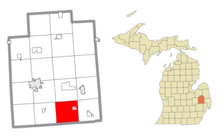
Almont is a village in Almont Township, Lapeer County, Michigan. Its population was 2,846 at the 2020 census.

<span class="mw-page-title-main">Dryden Township, Michigan</span> Civil township in Michigan, United States

Dryden Township is a civil township in Lapeer County in the U.S. state of Michigan, named in honor of the literary critic, John Dryden. The population was 4,768 at the 2010 census. The village of Dryden is located within the township.

<span class="mw-page-title-main">Miramiguoa Park, Missouri</span> Village in Missouri, United States

Miramiguoa Park is a village in Franklin County, Missouri, United States. The population was 120 at the 2010 census.

<span class="mw-page-title-main">Bel-Ridge, Missouri</span> City in Missouri, United States

Bel-Ridge is a suburban city in northern St. Louis County, Missouri, United States. The population was 2,737 at the 2010 census. Bel-Ridge is part of the Normandy Schools Collaborative. Bel-Ridge became a city in 2015 by a vote of the voters.

<span class="mw-page-title-main">Sycamore Hills, Missouri</span> Village in Missouri, United States

Sycamore Hills is a village in St. Louis County, Missouri, United States. The population is 560 at the 2020 census.

<span class="mw-page-title-main">Westwood, Missouri</span> Village in Missouri, United States

Westwood is a village in west St. Louis County, Missouri, United States. The population was 316 at the 2020 census.

<span class="mw-page-title-main">Wilbur Park, Missouri</span> Village in Missouri, United States

Wilbur Park is a village in St. Louis County, Missouri, United States. The population was 439 at the 2020 census.

<span class="mw-page-title-main">Cedar Creek, Nebraska</span> Village in Nebraska, United States

Cedar Creek is a village in Cass County, Nebraska, United States. The population was 465 at the 2020 census.

<span class="mw-page-title-main">Hanley Hills, Missouri</span> Village in Missouri, United States

Hanley Hills is a village in St. Louis County, Missouri, United States. The population was 2,101 at the 2010 census.

<span class="mw-page-title-main">Walton Hills, Ohio</span> Village in Ohio, United States

Walton Hills is a village in Cuyahoga County, Ohio, United States. The population was 2,033 at the 2020 census. A suburb of Cleveland, it is a part of the Cleveland metropolitan area.

<span class="mw-page-title-main">Addyston, Ohio</span> Village in Ohio, United States

Addyston is a village in Miami Township, Hamilton County, Ohio, United States. Located along the Ohio River, it is a western suburb of the neighboring city of Cincinnati. The population was 927 at the 2020 census.

<span class="mw-page-title-main">Evendale, Ohio</span> Village in Ohio, United States

Evendale is a village in Hamilton County, Ohio, United States, within the Cincinnati metropolitan area. The population was 2,669 at the 2020 census.

<span class="mw-page-title-main">Woodlawn, Ohio</span> Village in Ohio, United States

Woodlawn is a village in Hamilton County, Ohio, United States. The population was 3,916 at the 2020 census.

<span class="mw-page-title-main">Bethlehem, West Virginia</span> Village in West Virginia, United States

Bethlehem is a village in Ohio County, West Virginia, United States. It is part of the Wheeling, West Virginia Metropolitan Statistical Area. The population was 2,499 at the 2010 census.

<span class="mw-page-title-main">Bellevue, Wisconsin</span> Village in Wisconsin, United States

Bellevue is a village in Brown County, Wisconsin. It was a town until incorporating as a village on February 14, 2003. The population was 14,570 at the time of the 2010 census. Bellevue is part of the Green Bay metropolitan area. Bellevue sits around 4.34 miles (6.99 km) east from central Green Bay.

<span class="mw-page-title-main">Kekoskee, Wisconsin</span> Village in Wisconsin, United States

Kekoskee is a village in Dodge County, Wisconsin, United States. The population was 161 at the 2010 census.

<span class="mw-page-title-main">Avoca, Wisconsin</span> Village in Wisconsin, United States

Avoca is a village in Iowa County, Wisconsin, United States. The population was 637 at the 2010 census. It is part of the Madison Metropolitan Statistical Area. It is named after Avoca in Ireland.

<span class="mw-page-title-main">Dorchester, Wisconsin</span> Village in Wisconsin, United States

Dorchester is a village in Clark and Marathon counties in the U.S. state of Wisconsin, along the 45th parallel. It is part of the Wausau, Wisconsin Metropolitan Statistical Area. The population was 876 at the 2010 census. Of this, 871 were in Clark County, and only 5 were in Marathon County.

<span class="mw-page-title-main">Dryden (village), New York</span> Village in New York, United States

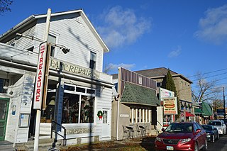
Dryden is a village in Tompkins County, New York, United States. The population was 1,890 at the 2010 census. The name was assigned by a clerk, interested in the classics, to honor poet John Dryden. The village is in the town of Dryden, east of Ithaca. It is near the border of Cortland County.

<span class="mw-page-title-main">Black Earth, Wisconsin</span> Village in Wisconsin, United States

Black Earth is a village in Dane County, Wisconsin, United States. The population was 1,338 at the 2010 census. The village is located within the Town of Black Earth. It is part of the Madison Metropolitan Statistical Area.

References

  1. "2020 U.S. Gazetteer Files". United States Census Bureau. Retrieved May 21, 2022.
  2. 1 2 "U.S. Census website". United States Census Bureau . Retrieved January 31, 2008.
  3. U.S. Geological Survey Geographic Names Information System: Dryden, Michigan
  4. "US Gazetteer files 2010". United States Census Bureau. Archived from the original on July 2, 2012. Retrieved November 25, 2012.
  5. "Census of Population and Housing". Census.gov. Retrieved June 4, 2015.
  6. "U.S. Census website". United States Census Bureau . Retrieved November 25, 2012.
  7. "Champion Reaches 55-Year Milestone, Builds Unprecedented 1.7 Million Homes" . Retrieved February 3, 2017.