Columbiaville, Michigan

Last updated

Columbiaville, Michigan
Village of Columbiaville
Columbiaville Station Michigan 2019-2505.jpg
The historic Columbiaville station
Columbiaville, Michigan location.png
Location within Lapeer County
USA Michigan location map.svg
Red pog.svg
Columbiaville
Location within the state of Michigan
Usa edcp location map.svg
Red pog.svg
Columbiaville
Location within the United States
Coordinates: 43°09′25″N83°24′33″W / 43.15694°N 83.40917°W / 43.15694; -83.40917
CountryUnited States
State Michigan
County Lapeer
Townships Marathon and Oregon
Settled1847
Incorporated1879
Government
  Type Village council
  PresidentTom Wood
   Clerk Denise Baker
Area
[1]
  Total1.18 sq mi (3.05 km2)
  Land0.88 sq mi (2.28 km2)
  Water0.30 sq mi (0.77 km2)
Elevation
771 ft (235 m)
Population
 (2020)
  Total702
  Density797.73/sq mi (308.01/km2)
Time zone UTC-5 (Eastern (EST))
  Summer (DST) UTC-4 (EDT)
ZIP code(s)
48421
Area code 810
FIPS code 26-17460 [2]
GNIS feature ID0623646 [3]
Website Official website

Columbiaville is a village in Lapeer County in the U.S. state of Michigan. The population was 702 at the 2020 census. Located along the Flint River, the village is mostly within Marathon Township with a small portion extending south into Oregon Township.

Contents

History

The first settler on the site of the village was Levi D. Cutting, [4] a carpenter and cabinet maker by trade, who arrived with his family in 1847. His home in Columbiaville is still standing at the south corner of Water and Lapeer Streets. In 1848, George and Henry Niver built a saw mill on the banks of the Flint River and the place became known as "Niverville". William Peter, a neighbor of the Nivers from their previous residence in Columbia County, New York came to work in the Niver's sawmill. By 1852, he opened his own business, starting with a store. He eventually came into possession of the entire property of Columbiaville.

A post office was established in April 1857 with the name "Columbiaville". The Nivers originally suggested the name "Columbia" after their home county in New York, but at the time there was already another post office in Michigan with that name.

The village continued to grow with the inclusion of a large Steam Grist and Flouring Mill, built by William Peter. The Detroit and Bay City Railroad chose to route through Columbiaville and was opened to the public in 1872. The first depot was a wooden structure located on the east side of the track at Pine Street. In 1893 the brick depot was erected by William Peter, with the provision in the deed that all passenger trains were to stop in Columbiaville. The railroad provided great means of transportation and opportunity for the village. In 1892 the Peters along with Toledo workmen, built the William Peter Mansion. They moved into the sixteen room Mansion in 1896. Mrs. Peter stated that the location of the home was chosen for convenience of being right downtown in the center of activity. Peter soon after became ill and died on October 23, 1899, at age 75. He is buried at Woodlawn Cemetery. The first automobile traveled into the village in 1903, and was not initially well accepted by all residents who were in fear of witch craft. The first gas station in the village was established in the early 1900s by Standard Oil Company. Early automobile dealers were Roy Osborne, who built a large garage and dealership display on Water Street in 1920. Thomas Ward established Willey's Overland Garage in the 1920s. [5] [6] [7]

Geography

According to the United States Census Bureau, the village has a total area of 1.15 square miles (2.98 km2), of which 0.85 square miles (2.20 km2) is land and 0.30 square miles (0.78 km2) is water. [8]

Demographics

Historical population
CensusPop.Note
1880 326
1890 57877.3%
1900 457−20.9%
1910 369−19.3%
1920 65677.8%
1930 477−27.3%
1940 66439.2%
1950 78918.8%
1960 87811.3%
1970 9356.5%
1980 9531.9%
1990 934−2.0%
2000 815−12.7%
2010 787−3.4%
2020 702−10.8%
U.S. Decennial Census [9]

2010 census

As of the census [10] of 2010, there were 787 people, 299 households, and 207 families residing in the village. The population density was 925.9 inhabitants per square mile (357.5/km2). There were 335 housing units at an average density of 394.1 per square mile (152.2/km2). The racial makeup of the village was 95.2% White, 0.4% Native American, 0.1% Asian, 2.5% from other races, and 1.8% from two or more races. Hispanic or Latino of any race were 4.6% of the population.

There were 299 households, of which 35.5% had children under the age of 18 living with them, 48.5% were married couples living together, 13.4% had a female householder with no husband present, 7.4% had a male householder with no wife present, and 30.8% were non-families. 27.1% of all households were made up of individuals, and 13% had someone living alone who was 65 years of age or older. The average household size was 2.63 and the average family size was 3.18.

The median age in the village was 36.4 years. 27.1% of residents were under the age of 18; 9.2% were between the ages of 18 and 24; 25.7% were from 25 to 44; 26.1% were from 45 to 64; and 11.9% were 65 years of age or older. The gender makeup of the village was 47.8% male and 52.2% female.

2000 census

As of the census [2] of 2000, there were 815 people, 304 households, and 216 families residing in the village. The population density was 940.8 inhabitants per square mile (363.2/km2). There were 328 housing units at an average density of 378.6 per square mile (146.2/km2). The racial makeup of the village was 96.07% White, 0.25% African American, 0.49% Native American, 0.74% Asian, 1.23% from other races, and 1.23% from two or more races. Hispanic or Latino of any race were 1.60% of the population.

There were 304 households, out of which 36.8% had children under the age of 18 living with them, 53.9% were married couples living together, 14.1% had a female householder with no husband present, and 28.9% were non-families. 24.3% of all households were made up of individuals, and 10.2% had someone living alone who was 65 years of age or older. The average household size was 2.68 and the average family size was 3.20.

In the village, the population was spread out, with 28.0% under the age of 18, 8.7% from 18 to 24, 33.1% from 25 to 44, 19.5% from 45 to 64, and 10.7% who were 65 years of age or older. The median age was 33 years. For every 100 females, there were 91.3 males. For every 100 females age 18 and over, there were 85.8 males.

The median income for a household in the village was $39,844, and the median income for a family was $45,750. Males had a median income of $40,156 versus $20,000 for females. The per capita income for the village was $16,216. About 3.2% of families and 4.3% of the population were below the poverty line, including 2.7% of those under age 18 and 4.2% of those age 65 or over.

Related Research Articles

<span class="mw-page-title-main">Michiana, Michigan</span> Village in Michigan, United States

Michiana is a village in New Buffalo Township, Berrien County in the extreme southwest corner of the U.S. state of Michigan. The population was 200 at the 2020 census.

<span class="mw-page-title-main">Tekonsha, Michigan</span> Village in Michigan, United States

Tekonsha is a village in Tekonsha Township, Calhoun County in the U.S. state of Michigan. It is part of the Battle Creek, Michigan Metropolitan Statistical Area. The population was 653 at the 2020 census.

<span class="mw-page-title-main">Edwardsburg, Michigan</span> Village in Michigan, United States

Edwardsburg is a village within Ontwa Township in Cass County in the U.S. state of Michigan, northeast of South Bend. The population was 1,304 at the 2020 census. It is part of the South Bend–Mishawaka, IN-MI, Metropolitan Statistical Area.

<span class="mw-page-title-main">Ashley, Michigan</span> Village in Michigan, United States

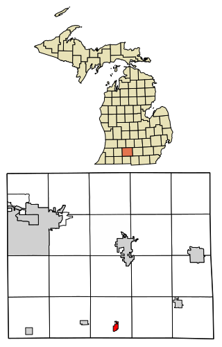
Ashley is a village in Gratiot County in the U.S. state of Michigan. The population was 508 at the 2020 census. The village is located in the northwest corner of Elba Township. No major state trunkline runs through the village, although M-57 passes within one mile to the south. Ashley was platted in 1884.

<span class="mw-page-title-main">Kinde, Michigan</span> Village in Michigan, United States

Kinde is a village in Huron County in the U.S. state of Michigan. The population was 448 at the 2010 census.

<span class="mw-page-title-main">Pigeon, Michigan</span> Village in Michigan, United States

Pigeon is a village in Huron County in the U.S. state of Michigan. The population was 1,208 at the 2010 census. The village is within Winsor Township.

<span class="mw-page-title-main">Port Austin, Michigan</span> Village in Michigan, United States

Port Austin is a village in Huron County in the U.S. state of Michigan. The population was 664 at the 2010 census. The village is within Port Austin Township.

<span class="mw-page-title-main">Stockbridge, Michigan</span> Village in Michigan, United States

Stockbridge is a village in Ingham County in the U.S. state of Michigan. It is located within Stockbridge Township about 36 miles (58 km) southeast from downtown Lansing. The population was 1,218 at the 2010 census.

<span class="mw-page-title-main">Webberville, Michigan</span> Village in Michigan, United States

Webberville is a village in Ingham County in the U.S. state of Michigan. It is located within Leroy Township. The population was 1,288 at the 2020 census.

<span class="mw-page-title-main">Muir, Michigan</span> Village in Michigan, United States

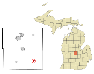
Muir is a village in Lyons Township, Ionia County in the U.S. state of Michigan. The population was 604 at the 2010 census.

<span class="mw-page-title-main">Alpha, Michigan</span> Village in Michigan, United States

Alpha is a village in Mastodon Township, Iron County of the U.S. state of Michigan. The population was 126 at the 2020 census. Alpha is the only village of Iron County.

<span class="mw-page-title-main">Hanover, Michigan</span> Village in Michigan, United States

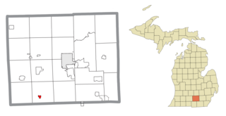
Hanover is a village in Jackson County in the U.S. state of Michigan. The population was 441 at the 2010 census. The village is located within Hanover Township.

<span class="mw-page-title-main">Powers, Michigan</span> Village in Michigan, United States

Powers is a village in Menominee County in the U.S. state of Michigan. The population was 381 at the 2020 census, down from 422 in 2010. Located within Spalding Township, it is part of the Marinette micropolitan area.

<span class="mw-page-title-main">Lakewood Club, Michigan</span> Village in Michigan, United States

Lakewood Club is a village in Dalton Township of Muskegon County in the U.S. state of Michigan. The population was 1,340 at the 2020 census.

<span class="mw-page-title-main">Chesaning Township, Michigan</span> Civil township in Michigan, United States

Chesaning Township is a civil township of Saginaw County in the U.S. state of Michigan. The population was 4,659 at the 2010 Census. The township was organized in 1847.

<span class="mw-page-title-main">St. Charles, Michigan</span> Village in Michigan, United States

St. Charles is a village in Saginaw County in the U.S. state of Michigan. The village is located in the northwest corner of St. Charles Township with portions of the village located within Brant and Swan Creek townships. The population was 2,054 at the 2010 census.

<span class="mw-page-title-main">Carsonville, Michigan</span> Village in Michigan, United States

Carsonville is a village in Sanilac County of the U.S. state of Michigan. The population was 527 at the 2010 census. The village is situated at 43°25′37″N82°40′17″W on the boundary between Bridgehampton Township and Washington Township, with about half the village in each.

<span class="mw-page-title-main">Burr Oak, Michigan</span> Village in Michigan, United States

Burr Oak is a village in St. Joseph County in the U.S. state of Michigan. As of the 2010 census, the village population was 828. The village is located within Burr Oak Township.

<span class="mw-page-title-main">Breedsville, Michigan</span> Village in Michigan, United States

Breedsville is a village in Van Buren County of the U.S. state of Michigan. The population was 199 at the 2010 census. The village is within Columbia Township.
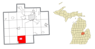
Lennon is a village in the U.S. state of Michigan. The population was 511 at the 2010 census. The village is located along M-13 within Venice Township in Shiawassee County to the west and Clayton Township in Genesee County to the east.

References

  1. "2020 U.S. Gazetteer Files". United States Census Bureau. Retrieved May 21, 2022.
  2. 1 2 "U.S. Census website". United States Census Bureau . Retrieved January 31, 2008.
  3. U.S. Geological Survey Geographic Names Information System: Columbiaville, Michigan
  4. "Village of Columbiaville (Village History)". columbiaville.org. Retrieved October 17, 2018.
  5. "Village of Columbiaville". History of Lapeer County, Michigan : with illustrations and biographical sketches of some of its prominent men and pioneers. Ann Arbor, Mich.: University of Michigan Library. 2005 [1884]. pp. 139–271. Retrieved October 14, 2006.
  6. Romig, Walter (1986) [1973]. Michigan Place Names. Detroit, Michigan: Wayne State University Press. ISBN   0-8143-1838-X.
  7. "Village History" . Retrieved October 14, 2006. The site credits Footsteps Into the Past - A history of the Columbiaville Area by Robert L. Blue
  8. "US Gazetteer files 2010". United States Census Bureau. Archived from the original on July 2, 2012. Retrieved November 25, 2012.
  9. "Census of Population and Housing". Census.gov. Retrieved June 4, 2015.
  10. "U.S. Census website". United States Census Bureau . Retrieved November 25, 2012.