Metamora, Michigan

Last updated

Metamora, Michigan
Village of Metamora
Village of Metamora.jpg
Metamora, Michigan location.png
Location within Lapeer County
USA Michigan location map.svg
Red pog.svg
Metamora
Location within the state of Michigan
Usa edcp location map.svg
Red pog.svg
Metamora
Location within the United States
Coordinates: 42°56′29″N83°17′19″W / 42.94139°N 83.28861°W / 42.94139; -83.28861
CountryUnited States
State Michigan
County Lapeer
Township Metamora
Settled1843
Incorporated1885
Government
  Type Village council
  PresidentJohn Clark
   Clerk Tina Sauve
Area
[1]
  Total0.83 sq mi (2.16 km2)
  Land0.83 sq mi (2.15 km2)
  Water0.00 sq mi (0.00 km2)
Elevation
1,042 ft (318 m)
Population
 (2020)
  Total594
  Density715.67/sq mi (276.32/km2)
Time zone UTC-5 (Eastern (EST))
  Summer (DST) UTC-4 (EDT)
ZIP code(s)
48455
Area code 810
FIPS code 26-53340 [2]
GNIS feature ID0632164 [3]
Website Official website

Metamora is a village in Lapeer County in the U.S. state of Michigan. The population was 594 at the 2020 census. The village is located within Metamora Township.

Contents

Geography

According to the United States Census Bureau, the village has a total area of 0.83 square miles (2.15 km2), all land. [4]

Demographics

Historical population
CensusPop.Note
1880 236
1890 31433.1%
1900 313−0.3%
1910 276−11.8%
1920 271−1.8%
1930 2938.1%
1940 281−4.1%
1950 39038.8%
1960 45215.9%
1970 4683.5%
1980 55217.9%
1990 447−19.0%
2000 50713.4%
2010 56511.4%
2020 5945.1%
U.S. Decennial Census [5]

2010 census

As of the census [6] of 2010, there were 565 people, 216 households, and 151 families living in the village. The population density was 680.7 inhabitants per square mile (262.8/km2). There were 245 housing units at an average density of 295.2 per square mile (114.0/km2). The racial makeup of the village was 98.1% White, 0.4% African American, 0.5% Native American, 0.2% Asian, 0.2% from other races, and 0.7% from two or more races. Hispanic or Latino of any race were 1.4% of the population.

There were 216 households, of which 38.4% had children under the age of 18 living with them, 56.5% were married couples living together, 8.8% had a female householder with no husband present, 4.6% had a male householder with no wife present, and 30.1% were non-families. 24.5% of all households were made up of individuals, and 7.4% had someone living alone who was 65 years of age or older. The average household size was 2.62 and the average family size was 3.11.

The median age in the village was 39.4 years. 27.8% of residents were under the age of 18; 5.6% were between the ages of 18 and 24; 24.1% were from 25 to 44; 30.7% were from 45 to 64; and 11.7% were 65 years of age or older. The gender makeup of the village was 48.5% male and 51.5% female.

2000 census

As of the census [2] of 2000, there were 507 people, 188 households, and 137 families living in the village. The population density was 765.4 inhabitants per square mile (295.5/km2). There were 204 housing units at an average density of 308.0 per square mile (118.9/km2). The racial makeup of the village was 96.84% White, 0.39% Native American, 0.20% Asian, and 2.56% from two or more races. Hispanic or Latino of any race were 0.79% of the population.

There were 188 households, out of which 33.0% had children under the age of 18 living with them, 60.6% were married couples living together, 9.6% had a female householder with no husband present, and 27.1% were non-families. 19.7% of all households were made up of individuals, and 6.4% had someone living alone who was 65 years of age or older. The average household size was 2.70 and the average family size was 3.14.

In the village, the population was spread out, with 26.6% under the age of 18, 8.3% from 18 to 24, 34.9% from 25 to 44, 19.7% from 45 to 64, and 10.5% who were 65 years of age or older. The median age was 34 years. For every 100 females, there were 92.0 males. For every 100 females age 18 and over, there were 97.9 males.

The median income for a household in the village was $58,088, and the median income for a family was $63,750. Males had a median income of $41,563 versus $26,563 for females. The per capita income for the village was $19,548. About 3.6% of families and 3.6% of the population were below the poverty line, including 1.4% of those under age 18 and 7.4% of those age 65 or over.

Schools

Metamora does not have a school system. Residents of the village attend Lapeer Community Schools, Dryden Community Schools, Oxford Community Schools, or private schools within Metro Detroit.

White Horse Inn

The White Horse Inn was founded in 1850 and operated continuously for 162 years, until it closed in 2012. It was housed in the same building, built in 1850, the entire time. The Inn underwent an extensive renovation with a planned reopening in late 2014. [7] The entire Metamora community donated time and skill to the renovation. Metamora is home to skilled craftsmen who usually work on high-end homes. Much of the materials came from the current owner's wood lot, or are recycled from a nearby farm which donated the remains of a century old barn, or from other old barns. In addition, Jean Louis Sauvat, came from France to paint charcoal images of horses on the interior wall. [8]

Events and attractions

Held annually is Metamora Country Days and Balloon Festival where about 20 balloons launch on Friday and Saturday evening. The festival is held on a late August weekend every year. [9]

The village hosts free summer concerts, held every Thursday evening from mid-June through late August in Harmer Park. [10]

Metamora and its surrounding township is notable for its beauty. The Metamora Hunt is a historic organization dedicated to the pursuit of foxes by horses and hounds. During the fall the hounds will often be seen being taken on hunts and take up the entire dirt road. [11]

Notable people

Related Research Articles

<span class="mw-page-title-main">Washburn, Illinois</span> Village in Illinois, United States

Washburn is a village mostly in Woodford County, with a small northerly portion in Marshall County, Illinois, United States. The population was 1,032 at the 2020 census. It is part of the Peoria Metropolitan Statistical Area.

<span class="mw-page-title-main">Metamora, Illinois</span> Village in Illinois, United States

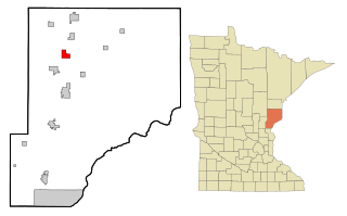
Metamora is a village in Metamora Township, Woodford County, Illinois, United States. The population was 3,636 at the 2010 census. Metamora is a growing suburb of Peoria and is part of the Peoria, Illinois Metropolitan Statistical Area.

<span class="mw-page-title-main">Attica Township, Michigan</span> Civil township in Michigan, United States

Attica Township is a civil township of Lapeer County in the U.S. state of Michigan. The population was 4,706 at the 2020 Census.

<span class="mw-page-title-main">Lapeer Township, Michigan</span> Civil township in Michigan, United States

Lapeer Township is a civil township of Lapeer County in the U.S. state of Michigan. The population was 5,056 at the 2010 Census. The name is an Americanization of the French La pierre, which means "flint" or "flint stone".

<span class="mw-page-title-main">Metamora Township, Michigan</span> Civil township in Michigan, United States

Metamora Township is a civil township of Lapeer County in the U.S. state of Michigan. The population was 4,249 at the 2010 Census.

<span class="mw-page-title-main">Clyde, Missouri</span> Village in Missouri, United States

Clyde is a village in eastern Nodaway County, Missouri, United States. The population was 82 at the 2010 census.

<span class="mw-page-title-main">Wilbur Park, Missouri</span> Village in Missouri, United States

Wilbur Park is a village in St. Louis County, Missouri, United States. The population was 439 at the 2020 census.

<span class="mw-page-title-main">Metamora, Ohio</span> Village in Ohio, United States

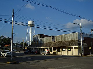
Metamora is a village in Fulton County, Ohio, United States. The population was 566 at the 2020 census.

<span class="mw-page-title-main">Evendale, Ohio</span> Village in Ohio, United States

Evendale is a village in Hamilton County, Ohio, United States, within the Cincinnati metropolitan area. The population was 2,669 at the 2020 census.

<span class="mw-page-title-main">Woodlawn, Ohio</span> Village in Ohio, United States

Woodlawn is a village in Hamilton County, Ohio, United States. The population was 3,916 at the 2020 census.

<span class="mw-page-title-main">Stone Creek, Ohio</span> Village in Ohio, United States

Stone Creek is a village in Tuscarawas County, Ohio, United States. The population was 153 at the 2020 census.

<span class="mw-page-title-main">Matamoras, Ohio</span> Village in Ohio, United States

Matamoras, also known as New Matamoras, is a village in Washington County, Ohio, United States, along the Ohio River. The population was 702 at the 2020 census. It is part of the Marietta micropolitan area.

<span class="mw-page-title-main">Beech Bottom, West Virginia</span> Village in West Virginia, United States

Beech Bottom is a village in Brooke County, West Virginia, United States, situated along the Ohio River. The population was 523 at the 2010 census. It is part of the Weirton–Steubenville metropolitan area.

<span class="mw-page-title-main">Friesland, Wisconsin</span> Village in Wisconsin, United States

Friesland is a village in Columbia County, Wisconsin, United States. The population was 320 at the 2020 census. It is part of the Madison Metropolitan Statistical Area, and was named after Friesland, one of the twelve provinces of the Netherlands.

<span class="mw-page-title-main">Avoca, Wisconsin</span> Village in Wisconsin, United States

Avoca is a village in Iowa County, Wisconsin, United States. The population was 637 at the 2010 census. It is part of the Madison Metropolitan Statistical Area. It is named after Avoca in Ireland.

<span class="mw-page-title-main">Wilson, Ohio</span> Village in Ohio, United States

Wilson is a village in Belmont and Monroe counties in the U.S. state of Ohio. The population was 129 at the 2020 census. It is part of the Wheeling metropolitan area.

<span class="mw-page-title-main">Verona, Ohio</span> Village in Ohio, United States

Verona is a village in Montgomery and Preble counties in the U.S. state of Ohio. The population was 403 at the 2020 census. It is part of the Dayton Metropolitan Statistical Area.

<span class="mw-page-title-main">Lowell, Wisconsin</span> Village in Wisconsin, United States

Lowell is a village in Dodge County, Wisconsin, United States, along the Beaver Dam River. The population was 340 at the 2010 census. The village is located within the Town of Lowell.

<span class="mw-page-title-main">Bloomington, Wisconsin</span> Village in Wisconsin, United States

Bloomington is a village in Grant County, Wisconsin, United States. The population was 735 as of the 2010 census. The village is located within the Town of Bloomington.

<span class="mw-page-title-main">Elba Township, Lapeer County, Michigan</span> Civil township in Michigan, United States

Elba Township is a civil township of Lapeer County in the U.S. state of Michigan. The population was 5,250 at the 2010 Census.

References

  1. "2020 U.S. Gazetteer Files". United States Census Bureau. Retrieved May 21, 2022.
  2. 1 2 "U.S. Census website". United States Census Bureau . Retrieved January 31, 2008.
  3. U.S. Geological Survey Geographic Names Information System: Metamora, Michigan
  4. "US Gazetteer files 2010". United States Census Bureau. Archived from the original on January 25, 2012. Retrieved November 25, 2012.
  5. "Census of Population and Housing". Census.gov. Retrieved June 4, 2015.
  6. "U.S. Census website". United States Census Bureau . Retrieved November 25, 2012.
  7. "History". White Horse Inn. Retrieved October 17, 2018.
  8. Detroit Free Press, Saving White Horse, Sunday, October 26, 2014, pages 1A & 12A
  9. "Metamora Chamber - About MACC - Events". www.metamorachamber.org. Archived from the original on August 29, 2013.
  10. "Event - Music in the Park" . Retrieved March 1, 2022.
  11. "Metamora Hunt Club".