
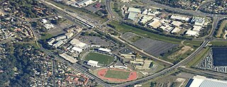
Campbelltown is a suburb located on the outskirts of the metropolitan area of Sydney, New South Wales, Australia. It is located in Greater Western Sydney 53 kilometres (33 mi) south-west of the Sydney central business district by road. Campbelltown is the administrative seat of the local government area of the City of Campbelltown. It is also acknowledged on the register of the Geographical Names Board of New South Wales as one of only four cities within the Sydney metropolitan area.

Camden is a historic town and suburb of Sydney, New South Wales, located 65 kilometres south-west of the Sydney central business district. Camden was the administrative centre for the local government area of Camden Council until July 2016 and is a part of the Macarthur region.
Narellan Vale is a suburb of Sydney, in the Australian state of New South Wales. Narellan Vale is located 60 kilometres south-west of the Sydney central business district, in the local government area of Camden Council and is part of the Macarthur region.

Narellan is a suburb of Sydney, New South Wales. Narellan is located 60 kilometres south-west of the Sydney central business district, in the local government area of Camden Council and is part of the Macarthur region.
Leumeah is a suburb of Sydney, in the state of New South Wales, Australia 52 kilometres south-west of the Sydney central business district, in the local government area of the City of Campbelltown. It is north of the suburb of Campbelltown and is part of the Macarthur region.
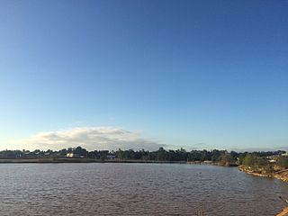
Spring Farm is a suburb of the Macarthur Region of Sydney in the state of New South Wales, Australia in Camden Council. It is on the east side of the Nepean River. Until recently, it was mainly farmland with a winery, an electricity substation and the Spring Farm Advanced Resource Recovery Facility, but it is currently in the process of suburban redevelopment.
Mount Annan is a suburb of Sydney, in the state of New South Wales, Australia. Mount Annan is located 60 kilometres south-west of the Sydney central business district, in the local government areas of Camden Council and Campbelltown City Council, and is part of the Macarthur region. The Federal Electorates of Hume and Macarthur divide the Gardens.

Camden South is a suburb of the Macarthur Region of Sydney in the state of New South Wales, Australia in Camden Council. It is to the immediate south of Camden, New South Wales and shares the same postcode 2570.
Catherine Field is a suburb of Sydney and part of the Macarthur Region in the state of New South Wales, Australia. Catherine Field is 43 kilometres south-west of the Sydney central business district, in the local government area of Camden Council.
Cobbitty is a semi-rural town of the Macarthur Region near the town of Camden, southwest of Sydney, in the state of New South Wales, Australia. The area is mostly farmland with a population of just over 4,000.

Currans Hill is a suburb of Sydney in the state of New South Wales, Australia. It is 60 km (37 mi) south-west of the Sydney central business district, in the local government area of Camden Council and is part of the Macarthur region.

Eschol Park is a suburb of Sydney, in the state of New South Wales, Australia. Eschol Park is located 60 kilometres south-west of the Sydney central business district, in the local government area of the City of Campbelltown and is part of the Macarthur region.
Harrington Park is a suburb of the Macarthur Region of Sydney in the state of New South Wales, Australia in Camden Council. Once a grand estate, owned by the Fairfax family, it has recently been developed as a residential suburb. Harrington Park House has been restored by Harrington Estates who manage the property on behalf of the Fairfax Estate.
Bickley Vale is a suburb of the Macarthur Region of Sydney in the state of New South Wales, Australia in Camden Council.
Grasmere is a suburb of the Macarthur Region of Sydney in the state of New South Wales, Australia in Camden Council.
Ellis Lane is a suburb of the Macarthur Region of Sydney in the state of New South Wales, Australia in Camden Council.

Kirkham is a suburb of the Macarthur Region of Sydney in the state of New South Wales, Australia in Camden Council. The suburb is largely undeveloped at present and possibly will remain so since much of it is on low-lying flood-prone land.

Macarthur is a region in the south-west part of the Greater Sydney area, in the state of New South Wales, Australia. The region includes the local government areas of the City of Campbelltown, Camden Council, and Wollondilly Shire. It covers an area of 3,067 square kilometres and has a population of close to 310,000 residents. The region geographically forms the foothills between the Blue Mountains and Southern Highlands regions.

Appin is a town on the south-west fringe of Sydney in the Macarthur Region in Tharawal country near its boundary with Gandangara country, New South Wales, Australia in Wollondilly Shire. It is situated about 16 kilometres (9.9 mi) south of Campbelltown and 35 kilometres (22 mi) northwest of Wollongong.

The Camden Park Estate incorporating the Belgenny Farm is a heritage-listed large working historical farm located at Elizabeth Macarthur Avenue, in the outer south-western Sydney suburb of Camden South, New South Wales, Australia. It was designed by Henry Kitchen in c. 1800, John Verge in c. 1835 and A. J. Onslow in c. 1888 and built from 1819 to 1840 by John Macarthur in c. 1800, James English and Sons in c. 1888 and John Sulman c. 1895. The property is owned by Belgenny Farm Trust and Camden Park Preservation Committee. It was added to the New South Wales State Heritage Register on 22 December 2006. Today, part of the original estate contains the Elizabeth Macarthur Agricultural Institute; having originally served as a commercial sheep station and horticultural farm for the Macarthur family since the early 1800s.
