
New Unionville is an unincorporated community in Benton Township, Monroe County, in the U.S. state of Indiana.

Morton is a small unincorporated community in Clinton Township, Putnam County, in the U.S. state of Indiana. The town consists of little more than a general store, livestock sale barn and 18-20 houses.

Washington Township is one of fourteen townships in Morgan County, Indiana, United States. As of the 2010 census, its population was 17,073 and it contained 7,171 housing units. The township contains a portion of the Morgan–Monroe State Forest.

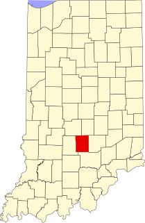
Indian Creek Township is one of eleven townships in Monroe County, Indiana, United States. As of the 2010 census, its population was 1,634 and it contained 681 housing units.
Fleener is an unincorporated community in Benton Township, Monroe County, in the U.S. state of Indiana.
Handy is an unincorporated community in Perry Township, Monroe County, in the U.S. state of Indiana.

Kirksville is an unincorporated community in Indian Creek Township, Monroe County, in the U.S. state of Indiana.

Marion Heights is an unincorporated community in northern Sugar Creek Township, Vigo County, in the U.S. state of Indiana.
Grange Corner is an unincorporated community in southeastern Lost Creek Township, Vigo County, in the U.S. state of Indiana.
Becks Grove is an unincorporated community in Van Buren Township, Brown County, in the U.S. state of Indiana.
Adel is an unincorporated community in eastern Franklin Township, Owen County, in the U.S. state of Indiana. It lies near the bridge on County Road 150 West over Raccoon Creek, which is a community nearly ten miles southwest of the city of Spencer, the county seat. Its elevation is 541 feet (165 m), and it is located at 39°11′31″N86°47′45″W.
Carp is an unincorporated community in the northeastern part of Montgomery Township, Owen County, in the U.S. state of Indiana. It lies near the intersection of US Highway 231 and County Road 50 East, which is a community nearly eight miles north of the city of Spencer, the county seat of Owen County. Its elevation is 722 feet, and it is located at 39°23′6″N86°45′39″W.
Cunot is an unincorporated community in Jackson Township, Owen County, in the U.S. state of Indiana. It lies near the intersection of Indiana Highway 42 and Indiana Highway 243, which is a community about twenty miles north of the city of Spencer, the county seat of Owen County. Its elevation is 722 feet, and it is located at 39°27′23″N86°51′17″W. Although this community is located within Owen County on its northern boundary, it has an address of Cloverdale, Indiana in Putnam County, which is about six miles northeast of the community.
Lewisville is an unincorporated community in the northeast corner of Harrison Township, Owen County, in the U.S. state of Indiana. It lies near the intersection of County Road 700 East and West Lewisville Road, which is a community about twenty miles northeast of the city of Spencer, the county seat. Its elevation is 771 feet, and it is located at 39°28′16″N86°37′55″W. This community lies on the border of Owen County and Morgan County.
New Maysville is an unincorporated community in Jackson Township, Putnam County, in the U.S. state of Indiana.
Groveland is an unincorporated community in Floyd Township, Putnam County, in the U.S. state of Indiana.
Limedale is an unincorporated community in Greencastle Township, Putnam County, in the U.S. state of Indiana.
Westland is an unincorporated community in Warren Township, Putnam County, in the U.S. state of Indiana.
Southport is an unincorporated community in Washington Township, Owen County, in the U.S. state of Indiana.
Taggart Crossing is an unincorporated community in Washington Township, Morgan County, in the U.S. state of Indiana.


