
Stinesville is a town in Bean Blossom Township, Monroe County, in the U.S. state of Indiana. The population was 198 at the 2010 census. It is part of the Bloomington, Indiana Metropolitan Statistical Area.

Brown Township is one of eleven townships in Montgomery County, Indiana, United States. As of the 2010 census, its population was 1,719 and it contained 739 housing units.
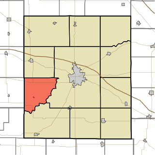
Ripley Township is one of eleven townships in Montgomery County, Indiana, United States. As of the 2010 census, its population was 977 and it contained 456 housing units.

Scott Township is one of eleven townships in Montgomery County, Indiana, United States. As of the 2010 census, its population was 837 and it contained 356 housing units.

Marion Township is one of thirteen townships in Owen County, Indiana, United States. As of the 2010 census, its population was 916 and it contained 464 housing units.

Jefferson Township is one of thirteen townships in Putnam County, Indiana. As of the 2010 census, its population was 1,252 and it contained 525 housing units.

Washington Township is one of thirteen townships in Putnam County, Indiana. As of the 2010 census, its population was 2,493 and it contained 1,086 housing units.

Washington Township is one of fourteen townships in Morgan County, Indiana, United States. As of the 2010 census, its population was 17,073 and it contained 7,171 housing units. The township contains a portion of the Morgan–Monroe State Forest.

Ogilville is a diffuse, unincorporated community in Ohio Township, Bartholomew County, in the U.S. state of Indiana. It is located along State Road 58 close to where it crosses over East Fork White Creek. It is located southwest on SR 58 of North Ogilville. There is a grocery there, also a fire-and-rescue service; and scattered homes.
Chrisman is an unincorporated community in Oak Run Township, Madison County, Ohio, United States. It is located at 39°49′59″N83°22′22″W, at the intersection of London-Circleville Road and Gregg Mill Road, about four miles southeast of London.

Cunot is an unincorporated community in Jackson Township, Owen County, in the U.S. state of Indiana. It lies near the intersection of Indiana Highway 42 and Indiana Highway 243, which is a community about twenty miles north of the city of Spencer, the county seat of Owen County. Its elevation is 722 feet, and it is located at 39°27′23″N86°51′17″W. Although this community is located within Owen County on its northern boundary, it has an address of Cloverdale, Indiana in Putnam County, which is about six miles northeast of the community.
Devore is an unincorporated community in the southwest portion of Taylor Township, Owen County, in the U.S. state of Indiana. It lies just south of the intersection of County Road 1000 North and County Road 100 East, which is a community about ten miles north of the city of Spencer, the county seat of Owen County. Its elevation is 755 feet, and it is located at 39°25′47″N86°45′10″W. This community is also known as Mill Grove.
Farmers is an unincorporated community in the southwest corner of Franklin Township, Owen County, in the U.S. state of Indiana. It lies just south of US Highway 231 at the intersection of 650 West, which is a community about twelve miles south of the city of Spencer, the county seat of Owen County. Its elevation is 591 feet, and it is located at 39°10′31″N86°53′30″W. This community is also known as Farmers Station.
Hubbell is an unincorporated community in the southwestern corner of Jefferson Township, Owen County, in the U.S. state of Indiana. It lies near the intersection of County Road 750 South and Indiana Highway 157, which is a community nearly twenty miles southwest of the city of Spencer, the county seat. Its elevation is 528 feet, and it is located at 39°10′59″N87°0′44″W. This community is also known as Hubbells Station.
Lewisville is an unincorporated community in the northeast corner of Harrison Township, Owen County, in the U.S. state of Indiana. It lies near the intersection of County Road 700 East and West Lewisville Road, which is a community about twenty miles northeast of the city of Spencer, the county seat. Its elevation is 771 feet, and it is located at 39°28′16″N86°37′55″W. This community lies on the border of Owen County and Morgan County.
New Hope is an unincorporated community in the southeast corner of Franklin Township, Owen County, in the U.S. state of Indiana. It lies near the intersection of County Road 740 South and County Road 285 West, which is a community about nine miles southwest of the city of Spencer, the county seat. Its elevation is 522 feet, and it is located at 39°10′59″N86°49′40″W.
Marion Mills is an unincorporated community in Marion Township, Owen County, in the U.S. state of Indiana.
Cagle Mill is an unincorporated community in Washington Township, Putnam County, in the U.S. state of Indiana.
Hancock Corner is an unincorporated community in Washington Township, Owen County, in the U.S. state of Indiana.
Mount Zion Corner is an unincorporated community in Gregg Township, Morgan County, in the U.S. state of Indiana.


