
Ocracoke is a census-designated place (CDP) and unincorporated town located at the southern end of Ocracoke Island, within Hyde County, North Carolina. The population was 948 at the 2010 census. In the 2020 census, the population had dropped to 797.

Cape Hatteras is a cape located at a pronounced bend in Hatteras Island, one of the barrier islands of North Carolina.

Cape Hatteras Light is a lighthouse located on Hatteras Island in the Outer Banks in the town of Buxton, North Carolina and is part of the Cape Hatteras National Seashore. It is the tallest lighthouse in the U.S. from base to tip at 210 feet. The lighthouse's semi-unique pattern makes it easy to recognize and famous. It is often ranked high on lists of most beautiful, and famous lighthouses in the US.

Rodanthe is an unincorporated community and census-designated place (CDP) located in Dare County, North Carolina, United States, on Hatteras Island, part of North Carolina's Outer Banks. As of the 2020 census it had a population of 213. Rodanthe, along with Waves and Salvo, are part of the settlement of Chicamacomico. Rodanthe includes the original Chicamacomico Life-Saving Station, decommissioned in 1954, but now a museum.

Waves is an unincorporated community and census-designated place (CDP) in Dare County, North Carolina, United States. It is on Hatteras Island, part of North Carolina's Outer Banks. As of the 2010 census it had a population of 134. Waves, along with Rodanthe and Salvo, are part of the settlement of Chicamacomico.
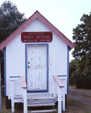
Salvo is a census-designated place located in Dare County, North Carolina, United States, on Hatteras Island, part of North Carolina's Outer Banks. As of the 2010 census, Salvo had a population of 229. Originally part of the settlement of Chicamacomico, Salvo was originally known as "Clarks" or "Clarksville."

Hatteras is an unincorporated village and census-designated place (CDP) in Dare County, North Carolina, United States, on the Outer Banks island of Hatteras, at its extreme southwestern tip. As of the 2010 census it had a population of 504. Immediately to the west of the village of Hatteras is Hatteras Inlet which separates Hatteras Island from the neighboring Ocracoke Island. North Carolina Highway 12 passes through the community linking it to Frisco to the east and Ocracoke to the west.

Buxton is an unincorporated community and census-designated place (CDP) on Hatteras Island near Cape Hatteras. It is located in Dare County in the U.S. state of North Carolina. As of the 2020 census, it had a population of 1,181. Located at the widest part of Hatteras Island, it is the largest community on Hatteras Island both in terms of area and population, and is home to the island's schools and other major public buildings and offices.

Fort Raleigh National Historic Site preserves the location of Roanoke Colony, the first English settlement in the present-day United States. The site was preserved for its national significance in relation to the founding of the first English settlement in North America in 1587. The colony, which was promoted and backed by entrepreneurs led by Englishman Sir Walter Raleigh, failed sometime between 1587 and 1590 when supply ships failed to arrive on time. When next visited, the settlement was abandoned with no survivors found. The fate of the "Lost Colony" was a celebrated mystery, although most modern academic sources agree that the settlers likely assimilated into local indigenous tribes.

The Ponce de Leon Inlet Light is a lighthouse and museum located at Ponce de León Inlet in Central Florida. At 175 feet (53 m) in height, it is the tallest lighthouse in the state and one of the tallest in the United States. It is located between St. Augustine Light and Cape Canaveral Light. Restored by the Ponce de Leon Inlet Lighthouse Preservation Association, the lighthouse became a National Historic Landmark in 1998.

The Cape Lookout Lighthouse is a 163-foot-high lighthouse located on the southern Outer Banks of North Carolina. It flashes every 15 seconds and is visible at least 12 miles out to sea and up to 19 miles. It is one of the very few lighthouses that operate during the day. It became fully automated in 1950. The Cape Lookout Lighthouse is the only such structure in the United States to bear the checkered daymark, intended not only for differentiation between similar light towers, but also to show direction. The center of the black diamonds points in a north-south direction, while the center of the white diamonds points east-west.

The Pritchard House is a historic house in Titusville, Florida, United States. It is located at 424 South Washington Avenue. On January 12, 1990, it was added to the U.S. National Register of Historic Places. The house is owned by the Brevard County Board of County Commissioners and operated by the North Brevard Heritage Foundation.

The Hatteras Weather Bureau Station is a wood-frame building in Hatteras, North Carolina built in 1901 for what was then called the U.S. Weather Bureau. The then-remote location on the Outer Banks of North Carolina provided data on conditions in the Atlantic Ocean from a fixed location that was farther into the ocean environment than any on the Atlantic coast. The building served as a weather station from 1902 to 1946, when it was converted to living quarters for Weather Bureau personnel. In 1952 the property was turned over to the U.S. Coast Guard, which used it until 1958, when it was transferred to the National Park Service for use by Cape Hatteras National Seashore. From 1958 to 1976 the building was used as a research station, first by Duke University and later by North Carolina State University for investigations concerning marine invertebrates.
The Department of Virginia and North Carolina was a United States Military department encompassing Union-occupied territory in the Confederate States during the Civil War. In 1863 it was formed by the merging of two previously existing departments: the Department of Virginia and the Department of North Carolina. In 1865 the two departments were once again separated.

The Jarrett House is a historic hotel and restaurant located near the intersection of US Highways 23 and 441 in Dillsboro, Jackson County, North Carolina.

St. Mary Historic District is a national historic district located at Lafayette, Tippecanoe County, Indiana. In 1864, St. Mary's Catholic Church relocated from its original site at Fifth and Brown Streets to Columbia Street. With the move, many of the congregation also moved to this area. The Church became both a religious and social center for the neighborhood. Many of the homes date from the 1860s and 1870s and include fine examples of the Italianate, Greek Revival and Queen Anne styles as well as vernacular house types. Most of the people who built in this area were Lafayette businessmen. At 1202 Columbia Street James Ball, a local wholesale grocer left his name stamped into the front steps. Across the street is the James H. Ward House, who along with his brother, William, owned a local carpet and wallpaper business.
Merchants and Farmers National Bank Building was a historic bank building in Charlotte, Mecklenburg County, North Carolina. It was built in 1871–1872, a three-story, brick building with a stuccoed front and Italianate style cast iron trim manufactured by the Mecklenburg Iron Works. The building housed Independent Order of Odd Fellows lodges that met there from the 1870s through 1920. It was the oldest surviving commercial building in the central business district of Charlotte until it was demolished in 1989.
SS E.M. Clark was an American merchant ship of the first half of the 20th century. A steam tanker, she was laid down in 1921 at the Federal Shipbuilding Company in Kearny, New Jersey, and entered service with Imperial Oil Ltd of Vancouver, British Columbia as Victolite. She was sold to Standard Oil of New Jersey and New York in 1926, and renamed E.M. Clark. She was sunk off Cape Hatteras, North Carolina on March 18, 1942, by the German U-boat U-124. The shipwreck is readily accessible to recreational technical divers, resting in 260 feet (79 m) of water.

Ellsworth Historic District, also known as Ellsworth Addition, is a national historic district located at Lafayette, Tippecanoe County, Indiana. The district encompasses 144 contributing buildings, 1 contributing site, and 4 contributing structures in a predominantly residential section of Lafayette. It developed between about 1844 and 1936 and includes representative examples of Italianate, Second Empire, Queen Anne, and Bungalow / American Craftsman style architecture. Located in the district are the separately listed Falley Home, Moses Fowler House, and Temple Israel. Other notable buildings include the Second Presbyterian Church (1894-1895), Alexander House, Ball Brothers House, Falley Townhouse, Home Block, Annie Fowler House, and Duplex Townhouse.

The Horace H. Ellsworth House is a historic house at 316 Palisado Avenue in Windsor, Connecticut. It was built in 1872 for one of Windsor's leading citizens, and is a fine example of Italianate architecture executed in brick. It was listed on the National Register of Historic Places in 1988.


