Elne

Last updated • 4 min readFrom Wikipedia, The Free Encyclopedia
Elne
Cloitre d'Elne - galerie nord.jpg
Cloister of Elne
Blason Elne.svg
Location of Elne
Elne
France location map-Regions and departements-2016.svg
Red pog.svg
Elne
Languedoc-Roussillon-Midi-Pyrenees region location map.svg
Red pog.svg
Elne
Coordinates: 42°35′59″N2°58′16″E / 42.5997°N 02.971°E / 42.5997; 02.971
Country France
Region Occitania
Department Pyrénées-Orientales
Arrondissement Céret
Canton La Plaine d'Illibéris
Intercommunality CC des Albères, de la Côte Vermeille et de l'Illibéris
Government
  Mayor (20202026) Nicolas Garcia [1]
Area
1
21.29 km2 (8.22 sq mi)
Population
 (2021) [2]
9,428
  Density440/km2 (1,100/sq mi)
Time zone UTC+01:00 (CET)
  Summer (DST) UTC+02:00 (CEST)
INSEE/Postal code
66065 /66200
Elevation0–65 m (0–213 ft)
(avg. 23 m or 75 ft)
1 French Land Register data, which excludes lakes, ponds, glaciers > 1 km2 (0.386 sq mi or 247 acres) and river estuaries.

Elne (French pronunciation: [ɛln] ; Catalan : Elna [ˈɛlnə] ) is a commune in the Pyrénées-Orientales department in southern France. [3]

Contents

It lies in the former province of Roussillon, of which it was the first capital, being later replaced by Perpignan. Its inhabitants are still called Illibériens in reference to the city's Iberian name, Illiberis, one that it shared with the Illiberis that became Granada, Spain.

Geography

Elne is located in the canton of La Plaine d'Illibéris and in the arrondissement of Perpignan. It is situated 4 km (2.5 mi) from the Mediterranean near the Tech River, in Pyrénées-Orientales, 12 km (7.5 mi) from Perpignan and 7 km (4.3 mi) from Argelès.

Map of Elne and its surrounding communes Map commune FR insee code 66065.png
Map of Elne and its surrounding communes

History

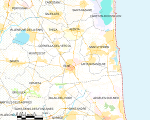
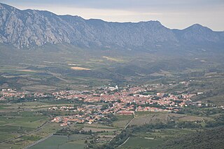
Elne, from the heights of its fortified site, dominates the narrow plain of Roussillon between the Pyrenees and the Mediterranean. Numerous archeological researches have shown that the surrounding countryside has been occupied since Neolithic times. Elne was an Iberian oppidum or fortified town. Elne is the oldest town in Roussillon and since it is situated on the way towards the Iberian Peninsula, successive civilisations have left their traces. The first mention of the settlement, under the name of Illiberis, occurs in the history of Livy (xxi.24). [4] It was the Iberian city at which Hannibal pitched camp having crossed the Pyrenees in 218 BCE, where he negotiated with the assembled Gaulish chiefs his safe passage through their territories on the way to Italy. In the first century CE, however, it was no more than "a modest vestige of a hitherto great city" (Pliny).

In the fourth century, Illiberis was renamed "Castrum Helenae" after Helena, the mother of Constantine, whence its modern name was derived by degrees. In 350 A.D., this was the location of the assassination of Constans, a son of Constantine. With the division of southern Gaul in 462, Elne became one of the "seven cities" of Septimania. Its Catholic bishopric was established in the 6th century. The first known bishop of Elne, Dominus, was mentioned in 571 in the Chronicle of John of Biclarum. The bishop of Elne attended the Council of Toledo in 599. Numerous synods were held by the bishops of Elne: That of 1027 in Toulouges upheld the Peace and Truce of God, that no one should attack his enemy from Saturday at nine o'clock to Monday at one. Further synods were held in 1058, 1114, 1335, 1337, 1338, 1339, 1340, and 1380.

When the Arabs crossed the Pyrenees in 719 Elne was one of the first towns to be attacked, and when the counts of Roussillon achieved independence, Perpignan became the capital of the county, with Elne remaining the Episcopal city.

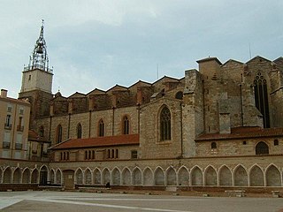
The high altar of the present cathedral of Sainte-Eulalie-et-Sainte-Julie was consecrated in 1069. Its Romanesque cloister was built in the 12th to 14th centuries. In 1285, under the Aragonese domination, during the Aragonese Crusade instigated by Pope Martin IV, the town was plundered, the cathedral set on fire and the people, who had taken refuge inside, massacred by the French troops of Philip III.

During the later Middle Ages, Elne was increasingly overshadowed by the growing prosperity of nearby Perpignan; the counts of Roussillon moved their seat from Elne to Perpignan, and after vicissitudes lasting two centuries the episcopal seat was finally transferred to Perpignan also, in 1601 by a Bull of Pope Clement VIII.

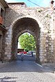
In 1472 the inhabitants of Elne revolted against French rule. The town, yet again besieged, was conquered and its captain, Bernat d'Oms, beheaded (1474). In 1493 Elne, along with all Roussillon, was returned to the Crown of Aragon. In 1641 Elne suffered another siege by the French and after the Treaty of the Pyrenees (1659), became French. The medieval ramparts were partly destroyed in 1680 on Louis XIV's orders.

Since then Elne has become an agricultural town which, in spite of repeated destructions caused by its several invaders, remains a witness to its past glories, attracting some 70,000 visitors annually.

In the twentieth century a sculptor and a painter have left their imprint: Aristide Maillol and Etienne Terrus, to whom a local museum is dedicated. "Pomone" by Maillol serves as the World War II war memorial, and the studio of Terrus, where Henri Matisse and André Derain were received, saw the birth of the Fauve movement.

Currently the city is extending towards the north, in a carefully planned urbanization "Las Trillas" extending over 40 hectares, which takes advantage of picturesque views of the cathedral. A pedestrian boulevard through the city, on the model of Barcelona's successful "Las Ramblas", is under way, as well as a new square, Place Jordi incorporating the ramparts of the upper city.

Demography

Historical population
YearPop.±% p.a.
1968 5,892    
1975 6,017+0.30%
1982 6,177+0.38%
1990 6,262+0.17%
1999 6,410+0.26%
2007 7,452+1.90%
2012 8,275+2.12%
2017 8,941+1.56%
Source: INSEE [5]

See also

Related Research Articles

<span class="mw-page-title-main">Perpignan</span> Prefecture and commune in Occitania, France

Perpignan is the prefecture of the Pyrénées-Orientales department in Southern France, in the heart of the plain of Roussillon, at the foot of the Pyrenees a few kilometres from the Mediterranean Sea and the scrublands of the Corbières massif. It is the centre of the Perpignan Méditerranée Métropole metropolitan area.

<span class="mw-page-title-main">Roussillon</span> Historical province in Pyrénées-Orientales, France

Roussillon was a historical province of France that largely corresponded to the County of Roussillon and part of the County of Cerdagne of the former Principality of Catalonia. It is part of the region of Northern Catalonia or French Catalonia, corresponding roughly to the present-day southern French département of Pyrénées-Orientales in the former region of Languedoc-Roussillon.

<span class="mw-page-title-main">Céret</span> Subprefecture of Pyrénées-Orientales, Occitanie

Céret is a commune in the Pyrénées-Orientales department in southern France. It is the capital of the historic Catalan comarca of Vallespir.

<span class="mw-page-title-main">Canet-en-Roussillon</span> Commune in Occitania, France

Canet-en-Roussillon is a commune and town in the French department of the Pyrénées-Orientales, administrative region of Occitania.

<span class="mw-page-title-main">Arrondissement of Céret</span> Arrondissement in Occitania, France

The arrondissement of Céret is an arrondissement of France in the Pyrénées-Orientales department in the Occitanie region. It has 64 communes. Its population is 134,629 (2021), and its area is 1,214.1 km2 (468.8 sq mi).

<span class="mw-page-title-main">Arrondissement of Perpignan</span> Arrondissement in Occitania, France

The arrondissement of Perpignan is an arrondissement of France in the Pyrénées-Orientales department in the Occitanie region. It has 39 communes. Its population is 292,142 (2021), and its area is 720.5 km2 (278.2 sq mi).

<span class="mw-page-title-main">Le Perthus</span> Commune in Occitania, France

Le Perthus is a commune in the Pyrénées-Orientales department in southern France. Natives of Le Perthus are called Perthusiens and, in 2021, there were 560 inhabitants.

<span class="mw-page-title-main">Perpignan Cathedral</span>

The Cathedral of Saint John the Baptist is a Roman Catholic cathedral, and a national monument of France, located in the town of Perpignan in Languedoc-Roussillon. It is dedicated to Saint John the Baptist.

<span class="mw-page-title-main">Elne Cathedral</span>

Elne Cathedral is a Roman Catholic church and former cathedral located in the town of Elne in the County of Roussillon, France.

<span class="mw-page-title-main">Alénya</span> Commune in Occitania, France

Alénya is a commune in the Pyrénées-Orientales department in southern France.

<span class="mw-page-title-main">Étienne Terrus</span> French painter (1857–1922)

Étienne Joseph Mathieu Terrus was a French painter from Roussillon.

<span class="mw-page-title-main">Le Boulou</span> Commune in Occitania, France

Le Boulou is a commune in the Pyrénées-Orientales department in southern France.

<span class="mw-page-title-main">Roman Catholic Diocese of Perpignan-Elne</span> Catholic diocese in France

The Diocese of Perpignan–Elne is a Latin diocese of the Catholic Church in France. The diocese comprises the Department of Pyrénées-Orientales. This see continues the old Diocese of Elne, which was renamed and had its see relocated at Perpignan, in 1601 after a papal bull of Pope Clement VIII. Its territory brought together the Diocese of Elne, part of the Spanish Diocese of Urgel known as French Cerdagne, three cantons of the Diocese of Alet, and two villages of the Diocese of Narbonne.

<span class="mw-page-title-main">Arles-sur-Tech</span> Commune in Occitania, France

Arles-sur-Tech is a commune in the Pyrénées-Orientales department in southern France.

<span class="mw-page-title-main">Saint-Paul-de-Fenouillet</span> Commune in Occitania, France

Saint-Paul-de-Fenouillet is a commune in the Pyrénées-Orientales department in southern France.

<span class="mw-page-title-main">Latour-Bas-Elne</span> Commune in Occitania, France

Latour-Bas-Elne is a commune in the Pyrénées-Orientales department in southern France.

<span class="mw-page-title-main">Pyrénées-Orientales</span> Department of France in Occitania

Pyrénées-Orientales, also known as Northern Catalonia, are a department of the region of Occitania, Southern France, adjacent to the northern Spanish frontier and the Mediterranean Sea. It borders the departments of Ariège to the northwest and Aude to the north, the Mediterranean Sea to the east and the Spanish province of Girona in Catalonia to the south and the country of Andorra to the west. It also surrounds the tiny Spanish exclave of Llívia, and thus has two distinct borders with Spain. In 2019, it had a population of 479,979. Some parts of the Pyrénées-Orientales are part of the Iberian Peninsula. It is named after the Pyrenees mountain range.

The Sordones were an ancient (Pre-Roman) people of the Iberian Peninsula. They are believed to have spoken the Iberian language. Their territory was located in the Roussillon, in what is now the French département of Pyrénées-Orientales and was limited in the west by the Pyrenees. They are classified as ancient Iberian or as ancient Gauls according to the sources.

The following is a timeline of the history of the city of Perpignan, France.

<span class="mw-page-title-main">Perpignan Méditerranée Métropole</span> Communauté urbaine in Occitania, France

The Perpinyà Metròpolis Mediterrani is the communauté urbaine, an intercommunal structure, centred on the city of Perpinyà. It is located in the Pyrénées-Orientales department, in the Occitanie region, southern France. It was created in January 2016, replacing the previous communauté d'agglomération Perpignan Méditerranée. Its area is 616.7 km2. Its population was 268,445 in 2018, of which 119,188 in Perpignan proper.

References

  1. "Répertoire national des élus: les maires" (in French). data.gouv.fr, Plateforme ouverte des données publiques françaises. 13 September 2022.
  2. "Populations légales 2021" (in French). The National Institute of Statistics and Economic Studies. 28 December 2023.
  3. INSEE commune file
  4. "Who was Who in Roman Times :History of Rome (Ab Urbe Condita) by Livy". Romansonline.com. Retrieved 2013-03-26.
  5. Population en historique depuis 1968, INSEE