Elroy, North Carolina

Last updated

Elroy, North Carolina
CDP
USA North Carolina location map.svg
Red pog.svg
Elroy, North Carolina
Location within the state of North Carolina
Coordinates: 35°19′51″N77°55′21″W / 35.33083°N 77.92250°W / 35.33083; -77.92250
Country United States
State North Carolina
County Wayne
Area
[1]
  Total6.54 sq mi (16.93 km2)
  Land6.54 sq mi (16.93 km2)
  Water0.00 sq mi (0.00 km2)
Elevation
[2]
115 ft (35 m)
Population
 (2020)
  Total3,755
  Density574.60/sq mi (221.84/km2)
Time zone UTC-5 (Eastern (EST))
  Summer (DST) UTC-4 (EDT)
FIPS code 37-21130 [3]
GNIS feature ID2402453 [2]

Elroy is a town in Wayne County, North Carolina, United States. In 2007, the estimated population was 3,905. [4] It is included in the Goldsboro, North Carolina Metropolitan Statistical Area.

Contents

Geography

According to the United States Census Bureau, the CDP has a total area of 6.4 square miles (17 km2), all of it land.

Demographics

Historical population
CensusPop.Note
2020 3,755
U.S. Decennial Census [5]

As of the census [3] of 2000, there were 3,896 people, 1,534 households, and 1,087 families residing in the CDP. The population density was 606.4 inhabitants per square mile (234.1/km2). There were 1,718 housing units at an average density of 267.4 per square mile (103.2/km2). The racial makeup of the CDP was 70.87% White, 21.20% African American, 0.21% Native American, 1.93% Asian, 4.03% from other races, and 1.77% from two or more races. Hispanic or Latino of any race were 6.88% of the population.

There were 1,534 households, out of which 33.9% had children under the age of 18 living with them, 53.8% were married couples living together, 12.4% had a female householder with no husband present, and 29.1% were non-families. 23.3% of all households were made up of individuals, and 5.7% had someone living alone who was 65 years of age or older. The average household size was 2.54 and the average family size was 2.99.

In the CDP, the population was spread out, with 24.9% under the age of 18, 10.5% from 18 to 24, 32.0% from 25 to 44, 23.1% from 45 to 64, and 9.4% who were 65 years of age or older. The median age was 35 years. For every 100 females, there were 104.8 males. For every 100 females age 18 and over, there were 102.6 males.

The median income for a household in the CDP was $35,286, and the median income for a family was $37,853. Males had a median income of $25,943 versus $21,776 for females. The per capita income for the CDP was $17,197. About 10.1% of families and 11.5% of the population were below the poverty line, including 15.4% of those under age 18 and 14.5% of those age 65 or over.

Education

Education in Elroy is administered by the Wayne County Public School system with children attending schools in nearby townships. Higher education is offered through Wayne Community College in Goldsboro.

Transportation

Passenger

Roads

Related Research Articles

<span class="mw-page-title-main">Wayne County, North Carolina</span> County in North Carolina, United States

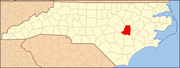
Wayne County is a county located in the U.S. state of North Carolina. As of the 2020 census, the population was 117,333. Its county seat is Goldsboro and it is home to Seymour Johnson Air Force Base.

<span class="mw-page-title-main">Drexel-Alvernon, Arizona</span> CDP in Pima County, Arizona

Drexel-Alvernon was a census-designated place (CDP) in Pima County, Arizona, United States. The population was 4,192 at the 2000 census.

<span class="mw-page-title-main">Del Rey, California</span> Census-designated place in California, United States

Del Rey is a census-designated place (CDP) in Fresno County, California, United States. The population was 1,639 at the 2010 census, up from 950 at the 2000 census. Del Rey is located 3.5 miles (5.6 km) south-southwest of Sanger, at an elevation of 344.

<span class="mw-page-title-main">North Merrick, New York</span> Hamlet and Census-designated place in New York, United States

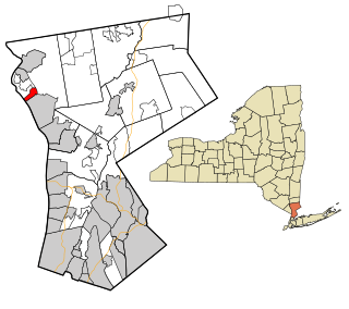
North Merrick is a hamlet and census-designated place in the Town of Hempstead, in Nassau County, near the South Shore of Long Island, in New York, United States. The population was 12,238 at the time of the 2020 census.

Clark Mills is a hamlet in Oneida County, New York, United States. The population was 1,905 at the 2010 census.

<span class="mw-page-title-main">Crugers, New York</span> Hamlet and census-designated place in Cortlandt, New York

Crugers is a hamlet and census-designated place (CDP) located in the town of Cortlandt, Westchester County, New York, United States. The population was 1,534 at the 2010 census.

<span class="mw-page-title-main">Woodlawn, North Carolina</span> Census-designated place in North Carolina, United States

Woodlawn is a census-designated place in Alamance County, North Carolina, United States.

<span class="mw-page-title-main">James City, North Carolina</span> Census-designated place in North Carolina, United States

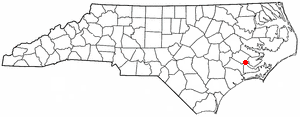
James City is an unincorporated area and census-designated place (CDP) in Craven County, North Carolina, United States. The population was 5,899 at the 2010 census. It is part of the New Bern, North Carolina Metropolitan Statistical Area.

<span class="mw-page-title-main">Eastover, North Carolina</span> Town in North Carolina, United States

Eastover is a town in Cumberland County, North Carolina, United States. The population was 3,628 at the 2010 census. It was incorporated on July 25, 2007.

<span class="mw-page-title-main">Snow Hill, North Carolina</span> Town in North Carolina, United States

Snow Hill is a town in Greene County, North Carolina, United States. The population was 1,595 at the 2010 census. It is the county seat of Greene County and is part of the Greenville Metropolitan Area. Snow Hill hosts numerous tennis tournaments during the year. Snow Hill is home to the Green Ridge Racquet Club. Many junior players and adults travel to Snow Hill in order to play in the USTA Sanctioned tournaments.

<span class="mw-page-title-main">Barker Heights, North Carolina</span> Census-designated place in North Carolina, United States

Barker Heights is an unincorporated area and census-designated place (CDP) in Henderson County, North Carolina, United States. The population was 1,254 at the 2010 census. It is part of the Asheville Metropolitan Statistical Area.

Brogden is a census-designated place (CDP) in Wayne County, North Carolina, United States. The population was 2,510 in 2020. It is included in the Goldsboro, North Carolina Metropolitan Statistical Area.

Eureka is a town in Wayne County, North Carolina, United States. The population was 197 at the 2010 census. It is included in the Goldsboro, North Carolina Metropolitan Statistical Area.

<span class="mw-page-title-main">Fremont, North Carolina</span> Town in North Carolina, United States

Fremont is a town in Wayne County, North Carolina, United States. The population was 1,255 at the 2010 census. It is included in the Goldsboro, North Carolina Metropolitan Statistical Area.

Mar-Mac is a census-designated place (CDP) in Wayne County, North Carolina, United States. The population was 3,011 at the 2007 census. It is included in the Goldsboro, North Carolina Metropolitan Statistical Area.

<span class="mw-page-title-main">Pikeville, North Carolina</span> Town in North Carolina, United States

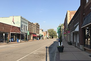
Pikeville is a town in Wayne County, North Carolina, United States. The population was 678 at the 2010 census. It is included in the Goldsboro, North Carolina Metropolitan Statistical Area. It is notable for being the home of Collier Motors, an automobile sales and service business established in 1955 that has remained an American Motors (AMC) dealership.

<span class="mw-page-title-main">Seven Springs, North Carolina</span> Town in North Carolina, United States

Seven Springs is a town in Wayne County, North Carolina, United States. It lies next to the Neuse River. The 2012 population was estimated at 111. It is included in the Goldsboro, North Carolina Metropolitan Statistical Area.

Walnut Creek is a village in Wayne County, North Carolina, United States. The population was 835 in 2010. It is included in the Goldsboro, North Carolina Metropolitan Statistical Area.

<span class="mw-page-title-main">Mount Healthy Heights, Ohio</span> Census-designated place in Ohio, United States

Mount Healthy Heights is a census-designated place (CDP) in Hamilton County, Ohio, United States. The population was 2,918 at the 2020 census.

<span class="mw-page-title-main">Mount Olive, North Carolina</span> Town in North Carolina, United States

Mount Olive is a town in Duplin and Wayne counties in the U.S. state of North Carolina. The population was 4,589 at the 2010 census. It is included in the Goldsboro, North Carolina Metropolitan Statistical Area. The town is home to the Mt. Olive Pickle Company and the University of Mount Olive.

References

  1. "ArcGIS REST Services Directory". United States Census Bureau. Retrieved September 20, 2022.
  2. 1 2 U.S. Geological Survey Geographic Names Information System: Elroy, North Carolina
  3. 1 2 "U.S. Census website". United States Census Bureau . Retrieved January 31, 2008.
  4. "Archived copy". Archived from the original on July 15, 2007. Retrieved January 29, 2008.{{cite web}}: CS1 maint: archived copy as title (link)
  5. "Census of Population and Housing". Census.gov. Retrieved June 4, 2016.