Seven Springs, North Carolina

Last updated

Seven Springs, North Carolina
Post Office, Seven Springs, North Carolina.jpg
Post office
USA North Carolina location map.svg
Red pog.svg
Seven Springs, North Carolina
Location within the state of North Carolina
Coordinates: 35°13′29″N77°50′42″W / 35.22472°N 77.84500°W / 35.22472; -77.84500
Country United States
State North Carolina
County Wayne
Area
[1]
  Total0.34 sq mi (0.88 km2)
  Land0.34 sq mi (0.88 km2)
  Water0.00 sq mi (0.00 km2)
Elevation
[2]
72 ft (22 m)
Population
 (2020)
  Total55
  Density162.72/sq mi (62.77/km2)
Time zone UTC-5 (Eastern (EST))
  Summer (DST) UTC-4 (EDT)
ZIP code
28578
Area code 252
FIPS code 37-60540 [3]
GNIS feature ID2407314 [2]
Website sevenspringsnc.org

Seven Springs is a town in Wayne County, North Carolina, United States. It lies next to the Neuse River. The 2012 population was estimated at 111. [4] It is included in the Goldsboro, North Carolina Metropolitan Statistical Area.

Contents

History

The town was incorporated as Whitehall in 1855, named in homage to the 1741 home of planter William Whitefield. In December 1862, during the American Civil War, a battle was fought near the town. In 1881 the community was reincorporated as White Hall. That year a hotel and resort opened to bring customers to seven mineral springs in the town's vicinity. The resort closed in 1944. In 1951 the town was renamed Seven Springs. [5] Seven Springs' population peaked in 1960 with 207 residents. In 1999 the Neuse River flooded during Hurricane Floyd, causing the town's population to halve. Hurricane Matthew in 2016 and Hurricane Florence in 2018 led to further decline; by 2020, the town had only 55 residents, and many of the businesses on the principal street in the community were left abandoned. [6]

Geography

According to the United States Census Bureau, the town has a total area of 0.3 square miles (0.78 km2), all of it land.[ citation needed ] It sits along the Neuse River. [5]

Demographics

Historical population
CensusPop.Note
1900 114
1910 17957.0%
1920 164−8.4%
1930 156−4.9%
1940 1709.0%
1950 19715.9%
1960 2075.1%
1970 188−9.2%
1980 166−11.7%
1990 163−1.8%
2000 86−47.2%
2010 11027.9%
2020 55−50.0%
U.S. Decennial Census [7]

As of the census [3] of 2010, there were 110 people, 43 households, and 27 families residing in the town. The population density was 261.9 inhabitants per square mile (101.1/km2). There were 67 housing units at an average density of 204.1 per square mile (78.8/km2). The racial makeup of the town was 81.8% White and 8.2% African American. [8]

There were 43 households, out of which 14.0% had children under the age of 18 living with them, 44.2% were married couples living together, 18.6% had a female householder with no husband present, and 34.9% were non-families. 32.6% of all households were made up of individuals, and 23.3% had someone living alone who was 65 years of age or older. The average household size was 2.00 and the average family size was 2.32.

In the town, the population was spread out, with 17.4% under the age of 18, 4.7% from 18 to 24, 20.9% from 25 to 44, 23.3% from 45 to 64, and 33.7% who were 65 years of age or older. The median age was 50 years. For every 100 females, there were 87.0 males. For every 100 females age 18 and over, there were 69.0 males.

The median income for a household in the town was $28,750, and the median income for a family was $29,063. Males had a median income of $29,375 versus $26,250 for females. The per capita income for the town was $46,922. There were no families and 8.0% of the population living below the poverty line, including no under eighteens and 16.0% of those over 64.

Education

Education in Seven Springs is administered by the Wayne County Public Schools system. Spring Creek Middle School and Spring Creek High School are located within the community. Higher education is offered through Wayne Community College in Goldsboro.

Related Research Articles

<span class="mw-page-title-main">Wayne County, North Carolina</span> County in North Carolina, United States

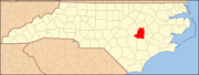
Wayne County is a county located in the U.S. state of North Carolina. As of the 2020 census, the population was 117,333. Its county seat is Goldsboro and it is home to Seymour Johnson Air Force Base.

<span class="mw-page-title-main">Lenoir County, North Carolina</span> County in North Carolina, United States

Lenoir County is a county in the U.S. state of North Carolina. As of the 2020 census, its population was 55,122. Its county seat is Kinston, located on the Neuse River, across which the county has its territory.

<span class="mw-page-title-main">Boiling Spring Lakes, North Carolina</span> City in North Carolina, United States

Boiling Spring Lakes is a city in Brunswick County, North Carolina, United States. The population was 5,943 at the 2020 census, up from 5,372 in 2010.

<span class="mw-page-title-main">Bridgeton, North Carolina</span> Town in North Carolina, United States

Bridgeton is a town in Craven County, North Carolina, United States. The population was 454 at the 2010 census. It is part of the New Bern, North Carolina Micropolitan Statistical Area.

<span class="mw-page-title-main">Neuse Forest, North Carolina</span> Census-designated place in North Carolina, United States

Neuse Forest is a census-designated place (CDP) in Craven County, North Carolina, United States. The population was 2,005 at the 2010 census. It is part of the New Bern, North Carolina Metropolitan Statistical Area.

<span class="mw-page-title-main">Snow Hill, North Carolina</span> Town in North Carolina, United States

Snow Hill is a town in Greene County, North Carolina, United States. The population was 1,595 at the 2010 census. It is the county seat of Greene County and is part of the Greenville Metropolitan Area. Snow Hill hosts numerous tennis tournaments during the year. Snow Hill is home to the Green Ridge Racquet Club. Many junior players and adults travel to Snow Hill in order to play in the USTA Sanctioned tournaments.

<span class="mw-page-title-main">Princeton, North Carolina</span> Town in North Carolina, United States

Princeton is a town in Johnston County, North Carolina, United States. As of the 2010 census it had a population of 1,194. Each May the town celebrates Princeton Community Day, a festival dedicated to promoting community involvement and town pride. The town holds municipal elections in November in odd-number years to elect its mayor and town council.

<span class="mw-page-title-main">Smithfield, North Carolina</span> Town in North Carolina, United States

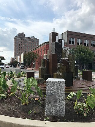
Smithfield is a town in and the county seat of Johnston County, North Carolina, United States. As of the 2010 census, its population was 10,966, and in 2019 the estimated population was 12,985. Smithfield is home to the Ava Gardner Museum and is situated along the Neuse River, where visitors enjoy the annual Smithfield Ham and Yam Festival, walks along the Buffalo Creek Greenway, and the historic downtown district. The town is located near North Carolina's Research Triangle and is about 30 miles (48 km) southeast of downtown Raleigh. The Raleigh-Durham-Cary combined statistical area has a population over 2 million residents.

<span class="mw-page-title-main">West Smithfield, North Carolina</span> Former census-designated place in North Carolina, United States

West Smithfield was an unincorporated community and census-designated place and is now a district of Smithfield, North Carolina in Johnston County, North Carolina, United States. The population was last recorded separately from Smithfield in 2000, when 59 people resided in the CDP.

<span class="mw-page-title-main">La Grange, North Carolina</span> Town in North Carolina, United States

La Grange is a town in Lenoir County, North Carolina, United States. The population was 2,873 based on the 2010 census. La Grange is located in North Carolina's Inner Banks region.

Brogden is a census-designated place (CDP) in Wayne County, North Carolina, United States. The population was 2,510 in 2020. It is included in the Goldsboro, North Carolina Metropolitan Statistical Area.

Elroy is a town in Wayne County, North Carolina, United States. In 2007, the estimated population was 3,905. It is included in the Goldsboro, North Carolina Metropolitan Statistical Area.

Eureka is a town in Wayne County, North Carolina, United States. The population was 197 at the 2010 census. It is included in the Goldsboro, North Carolina Metropolitan Statistical Area.

<span class="mw-page-title-main">Fremont, North Carolina</span> Town in North Carolina, United States

Fremont is a town in Wayne County, North Carolina, United States. The population was 1,255 at the 2010 census. It is included in the Goldsboro, North Carolina Metropolitan Statistical Area.

<span class="mw-page-title-main">Goldsboro, North Carolina</span> City in North Carolina, United States

Goldsboro, originally Goldsborough, is a city and the county seat of Wayne County, North Carolina, United States. The population was 33,657 at the 2020 census. It is the principal city of and is included in the Goldsboro, North Carolina Metropolitan Statistical Area. The nearby town of Waynesboro was founded in 1787, and Goldsboro was incorporated in 1847. It is the county seat of Wayne County.

Mar-Mac is a census-designated place (CDP) in Wayne County, North Carolina, United States. The population was 3,011 at the 2007 census. It is included in the Goldsboro, North Carolina Metropolitan Statistical Area.

<span class="mw-page-title-main">Pikeville, North Carolina</span> Town in North Carolina, United States

Pikeville is a town in Wayne County, North Carolina, United States. The population was 678 at the 2010 census. It is included in the Goldsboro, North Carolina Metropolitan Statistical Area. It is notable for being the home of Collier Motors, an automobile sales and service business established in 1955 that has remained an American Motors (AMC) dealership.

Walnut Creek is a village in Wayne County, North Carolina, United States. The population was 835 in 2010. It is included in the Goldsboro, North Carolina Metropolitan Statistical Area.

<span class="mw-page-title-main">Sims, North Carolina</span> Town in North Carolina, United States

Sims is a town in Wilson County, North Carolina, United States. The population was 282 at the 2010 census.

<span class="mw-page-title-main">Mount Olive, North Carolina</span> Town in North Carolina, United States

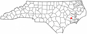
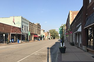
Mount Olive is a town in Duplin and Wayne counties in the U.S. state of North Carolina. The population was 4,589 at the 2010 census. It is included in the Goldsboro, North Carolina Metropolitan Statistical Area. The town is home to the Mt. Olive Pickle Company and the University of Mount Olive.

References

  1. "ArcGIS REST Services Directory". United States Census Bureau. Retrieved September 20, 2022.
  2. 1 2 U.S. Geological Survey Geographic Names Information System: Seven Springs, North Carolina
  3. 1 2 "U.S. Census website". United States Census Bureau . Retrieved January 31, 2008.
  4. Seven Springs, North Carolina
  5. 1 2 Powell 1976, p. 446.
  6. Flavelle, Christopher; Belleme, Mike (September 2, 2021). "Climate Change Is Bankrupting America's Small Towns". The New York Times.
  7. "Census of Population and Housing". Census.gov. Retrieved June 4, 2015.
  8. "U.S. Census website". United States Census Bureau . Retrieved March 11, 2020.

Works cited