Ensenada, New Mexico

Last updated

Ensenada, New Mexico
CDP
Rio Arriba County New Mexico Incorporated and Unincorporated areas Alcalde Highlighted.svg
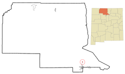
Location of Ensenada, New Mexico
Usa edcp location map.svg
Red pog.svg
Ensenada, New Mexico
Location in the United States
Coordinates: 36°43′51″N106°32′13″W / 36.73083°N 106.53694°W / 36.73083; -106.53694
CountryUnited States
State New Mexico
County Rio Arriba
Area
[1]
  Total1.46 sq mi (3.78 km2)
  Land1.46 sq mi (3.78 km2)
  Water0.00 sq mi (0.00 km2)
Elevation
[2]
7,520 ft (2,290 m)
Population
 (2020) [3]
  Total107
  Density73.39/sq mi (28.34/km2)
Time zone UTC-7 (Mountain (MST))
  Summer (DST) UTC-6 (MDT)
ZIP code
87575
Area code 505
FIPS code 35-24960
GNIS feature ID2584095 [2]

Ensenada is a census-designated place (CDP) in Rio Arriba County, New Mexico, United States. The population was 107 at the 2010 census. It had a post office from 1906 to 1958. [4]

Contents

Geography

View of Rabbit's Peak near Chama, NM and San Juan Mountains in Colorado from Ensenada, NM. Chama Valley.jpg
View of Rabbit's Peak near Chama, NM and San Juan Mountains in Colorado from Ensenada, NM.

According to the United States Census Bureau, the CDP has a total area of 1.46 square miles (3.8 km2), all land.

Demographics

Historical population
CensusPop.Note
2020 107
U.S. Decennial Census [5] [3]

As of the census of 2010, [6] there were 107 people, 42 households, and 30 families residing in the CDP. The population density was 73.3 people per square mile (28.3 people/km2). There were 54 housing units at an average density of 37.0 per square mile (14.3/km2). The racial makeup of the CDP was 72.0% White, 0% African American, 2.8% Native American, 0% Asian, 21.5% from other races, and 3.7% from two or more races. Hispanic or Latino of any race were 88.8% of the population.

There were 42 households, out of which 33.3% had children under the age of 18 living with them, 45.2% were married couples living together, 16.7% had a female householder with no husband present, and 28.6% were non-families. 26.2% of all households were made up of individuals, and 9.5% had someone living alone who was 65 years of age or older. The average household size was 2.55 and the average family size was 2.97.

Climate

This climatic region is typified by large seasonal temperature differences, with warm to hot (and often humid) summers and cold (sometimes severely cold) winters. According to the Köppen Climate Classification system, Ensenada has a humid continental climate, abbreviated "Dfb" on climate maps. [7]

Climate data for Ensenada, New Mexico
MonthJanFebMarAprMayJunJulAugSepOctNovDecYear
Mean daily maximum °C (°F)2
(35)
3
(37)
8
(46)
13
(55)
19
(67)
24
(75)
27
(81)
24
(76)
19
(67)
14
(58)
8
(46)
2
(35)
14
(57)
Mean daily minimum °C (°F)−11
(12)
−9
(16)
−6
(21)
−3
(27)
3
(37)
7
(44)
10
(50)
10
(50)
5
(41)
0
(32)
−5
(23)
−9
(15)
−1
(31)
Average precipitation mm (inches)53
(2.1)
51
(2)
64
(2.5)
46
(1.8)
41
(1.6)
28
(1.1)
51
(2)
76
(3)
56
(2.2)
53
(2.1)
51
(2)
48
(1.9)
610
(24.2)
Source: Weatherbase [8]

Education

It is within the Chama Valley Independent Schools school district. [9]

Related Research Articles

<span class="mw-page-title-main">Rio Arriba County, New Mexico</span> County in New Mexico, United States

Rio Arriba County is a county in the U.S. state of New Mexico. As of the 2020 census, the population was 40,363. Its county seat is Tierra Amarilla. Its northern border is the Colorado state line.

<span class="mw-page-title-main">East Whittier, California</span> Unincorporated community in California, United States

East Whittier is an unincorporated community in Los Angeles County, California, United States. The population was 9,757 at the 2010 census, up from 9,538 at the 2000 census. For statistical purposes, the United States Census Bureau has defined this community as a census-designated place (CDP). The name was changed from East La Mirada in 2012, likely due to its precise location in relation to the city of Whittier. The previous delineation of East Whittier CDP occurred during the 1960 census, when the area recorded a population of 19,884.

<span class="mw-page-title-main">North Highlands, California</span> Census-designated place in California, United States

North Highlands is a census-designated place (CDP) in Sacramento County, California, United States. It is part of the Sacramento–Arden-Arcade–Roseville Metropolitan Statistical Area. The population was 42,694 at the 2010 census, down from 44,187 at the 2000 census.

<span class="mw-page-title-main">Crestline, California</span> Census-designated place in California, United States

Crestline is a census-designated place in the San Bernardino Mountains of San Bernardino County, California, USA. The population was 10,770 at the 2010 census, up from 10,218 at the 2000 census.

<span class="mw-page-title-main">Shannon, Georgia</span> Place in Georgia, United States

Shannon is an unincorporated community and census-designated place (CDP) in Floyd County, Georgia, United States. It is part of the Rome, Georgia Metropolitan Statistical Area. The population was 1,862 at the 2010 census.

<span class="mw-page-title-main">Stearns, Kentucky</span> Census-designated place in Kentucky, United States

Stearns is an unincorporated community and census-designated place (CDP) in McCreary County, Kentucky, United States. The population was 1,365 at the 2020 census. It was founded by Justus Smith Stearns.

<span class="mw-page-title-main">Central Lake, Michigan</span> Village in Michigan, United States

Central Lake is a village in Antrim County in the U.S. state of Michigan. The population was 960 at the 2020 census. The village is located within Central Lake Township.

<span class="mw-page-title-main">Atlanta, Michigan</span> Census-designated place in Michigan, United States

Atlanta is a census-designated place and unincorporated community in the U.S. state of Michigan. It is the county seat of Montmorency County. The community had a population of 720 at the 2020 census, down from 827 in 2010. Atlanta has been nicknamed the "Elk Capital of Michigan".

<span class="mw-page-title-main">Fort Smith, Montana</span> Census-designated place in Montana, United States

Fort Smith is a census-designated place (CDP) in Big Horn County, Montana, United States. The population was 161 at the 2010 census. The town is named for the former Fort C.F. Smith. The North District of Bighorn Canyon National Recreation Area is accessed at Fort Smith.

<span class="mw-page-title-main">East Missoula, Montana</span> Census-designated place in Montana, United States

East Missoula is an unincorporated community and census-designated place (CDP) in Missoula County, Montana, United States. It is part of the Missoula metropolitan area. The population was 2,465 at the 2020 census, up from 2,157 in 2010.

<span class="mw-page-title-main">Alcalde, New Mexico</span> CDP in New Mexico, United States

Alcalde is a census-designated place (CDP) in Rio Arriba County, New Mexico, United States. The population was 285 at the 2010 census.

<span class="mw-page-title-main">Chama, New Mexico</span> Village in New Mexico, United States

Chama is a village in Rio Arriba County, New Mexico, United States. The population was 917 at the 2020 census. The village is located in the Rocky Mountains about 7 miles (11 km) south of the Colorado-New Mexico border.

<span class="mw-page-title-main">Dulce, New Mexico</span> Census-designated place in New Mexico, United States

Dulce is a census-designated place (CDP) in Rio Arriba County, New Mexico, United States. The population was 2,743 at the 2010 census, almost entirely Native American. It is the largest community and tribal headquarters of the Jicarilla Apache Reservation.

<span class="mw-page-title-main">San Juan, New Mexico</span> CDP in New Mexico, United States

San Juan is a census-designated place (CDP) in Rio Arriba County, New Mexico, United States. The population was 592 at the 2000 census.

<span class="mw-page-title-main">Wagner, South Dakota</span> City in South Dakota, United States

Wagner is a city in Charles Mix County, South Dakota, United States. The population was 1,490 at the 2020 census. The city is served by Wagner Municipal Airport as well as YST Transit buses.

<span class="mw-page-title-main">Olmito, Texas</span> Census-designated place in Texas, United States

Olmito is a census-designated place (CDP) in Cameron County, Texas, United States. Olmito is Spanish for "little elm". The population was 1,021 at the 2020 census. It is part of the Brownsville–Harlingen Metropolitan Statistical Area. Olmito is the self-described "mesquite capital of the world."

<span class="mw-page-title-main">Elbert, Texas</span> CDP in Texas, United States

Elbert is a census-designated place (CDP) in Throckmorton County, Texas, United States. The population was 30 at the 2010 census.

<span class="mw-page-title-main">Garfield, Texas</span> CDP in Texas, United States

Garfield is a census-designated place (CDP) in Travis County, Texas, United States. As of the 2020 census, the CDP population was 1,825.

<span class="mw-page-title-main">Newington, Virginia</span> Census-designated place in Virginia, United States

Newington is a census-designated place (CDP) in Fairfax County, Virginia, United States. As of the 2020 census, the population was 13,223. The population was 12,943 at the 2010 census. The 2010 census showed a significant decrease after half the population was split off to the newly created Newington Forest CDP.

<span class="mw-page-title-main">Boaz, West Virginia</span> CDP in West Virginia, United States

Boaz is a census-designated place (CDP) in Wood County, West Virginia, United States. It is part of the Parkersburg-Marietta-Vienna, WV-OH Metropolitan Statistical Area. As of the 2020 census, the CDP population was 1,321.

References

  1. "ArcGIS REST Services Directory". United States Census Bureau. Retrieved October 12, 2022.
  2. 1 2 U.S. Geological Survey Geographic Names Information System: Ensenada, New Mexico
  3. 1 2 "Census Population API". United States Census Bureau. Retrieved October 12, 2022.
  4. Julyan, Robert (1996). The Place Names of New Mexico. University of New Mexico Press. p. 125. ISBN   0826316891.
  5. "Census of Population and Housing". Census.gov. Retrieved June 4, 2016.
  6. "U.S. Census website". United States Census Bureau . Retrieved May 14, 2011.
  7. Climate Summary for Ensenada, New Mexico
  8. "Weatherbase.com". Weatherbase. 2013. Retrieved on October 3, 2013.
  9. "2020 CENSUS - SCHOOL DISTRICT REFERENCE MAP: Rio Arriba County, NM" (PDF). U.S. Census Bureau . Retrieved July 13, 2022.