Enterprise, Oklahoma | |
|---|---|
 Enterprise  Enterprise | |
| Coordinates: 35°13′32″N95°22′15″W / 35.22556°N 95.37083°W | |
| Country | United States |
| State | Oklahoma |
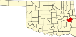
| County | Haskell |
| Area | |
• Total | 1.26 sq mi (3.27 km2) |
| • Land | 1.26 sq mi (3.27 km2) |
| • Water | 0 sq mi (0.00 km2) |
| Elevation | 732 ft (223 m) |
| Population (2020) | |
• Total | 170 |
| • Density | 134.6/sq mi (51.96/km2) |
| Time zone | UTC-6 (Central (CST)) |
| • Summer (DST) | UTC-5 (CDT) |
| ZIP Code | 74561 (Quinton) |
| Area codes | 918/539 |
| FIPS code | 40-24050 |
| GNIS feature ID | 2629917 [2] |
Enterprise is an unincorporated community and census-designated place (CDP) in Haskell County, Oklahoma, United States. It was first listed as a CDP following the 2010 census. [2]
Contents
The CDP is in western Haskell County. State highways 9 and 71 intersect in the northern part of the community. Highway 9 leads east 8 miles (13 km) to Whitefield and west 14 miles (23 km) to Eufaula, while Highway 71 leads northeast across Eufaula Dam 14 miles (23 km) to Porum and south 8 miles (13 km) to Quinton.
Enterprise is in the valley of Brooken Creek, which flows north to the Canadian River just upstream of Eufaula Dam.