Esh Winning

Last updated • 4 min readFrom Wikipedia, The Free Encyclopedia

Esh Winning
Durham UK location map.svg
Red pog.svg
Esh Winning
Location within County Durham
Population3,666 
OS grid reference NZ263443
Civil parish
Unitary authority
Ceremonial county
Region
Country England
Sovereign state United Kingdom
Post town DURHAM
Postcode district DH7
Police Durham
Fire County Durham and Darlington
Ambulance North East
UK Parliament
List of places
UK
England
County Durham
54°46′11″N1°42′13″W / 54.76977°N 1.70366°W / 54.76977; -1.70366

Esh Winning is a village, and location of a former colliery, in County Durham, England. It is situated in the Deerness Valley 5 miles (8 km) to the west of Durham. The village was founded by the Pease family in the 1850s to service a new mine on the Esh Estate.

Contents

The name of the village comes from two elements, first the older nearby village of Esh, a Saxon term for Ash, and second Winning, which was a Victorian term used when coal was found.

In March 2006 the National Lottery granted £25,200 towards the restoration of the Esh Winning Colliery banner. The banner group planned to use the money to restore the banner, which was on display at Beamish Museum, and to produce a replica for display at the Durham Miners' Gala. [1]

Opencast mining was performed in the hills around the village from the late 1970s to 1990s, after which the land was reclaimed and restored.

Media

The second episode of the 1975 series Days of Hope was set amongst the miners in Esh Winning during the 1921 lock-out.

Railway history

Deerness Valley Path near Esh Winning Deerness Valley Path, near Esh Winning - geograph.org.uk - 146443.jpg
Deerness Valley Path near Esh Winning

The village was served by the stone-and timber-built Waterhouses railway station on the Deerness Valley Railway. Although the goods yard was located in the village of Waterhouses, passenger service was handled through Esh Winning. The station opened on 1 November 1877, and closed to passengers on 29 October 1951 and to freight on 28 December 1964. The route of the line is now part of the eight-mile Deerness Valley Railway Path.

Memorial Hall

The Grade II-listed Memorial Hall is one of the village's largest buildings; it was built in 1923 as a memorial to the miners killed in World War I. Initially it was used as a meeting hall and community centre, before being converted in the 1920s to a cinema and ballroom and renamed The Majestic by the locals.

The hall was designed by architect local J. A. Robson and built in Edwardian Baroque style with a number of rooms. [2] It was perhaps a little too grand for a small community and experienced financial difficulties in the late 1920s, but continued to operate a cinema and ballroom for many decades afterwards. The hall became a makeshift barracks during World War II, and then a bingo hall and disco in the 1960s before being abandoned in the 1970s.

The building was disused since the 1970s, despite several attempts to restore and redevelop the building, none of which got beyond the planning stage. In 2009 the building was badly deteriorated with the roof collapsing and the facade in disrepair. The hall was saved from demolition by developer Michael Brett who planned to renovate the building as residences for vulnerable people. The project stalled, but recommenced in October 2011 with completion in 2012. Durham City MP Roberta Blackman-Woods officially opened the renamed Eshwin Hall on Friday, October 19.

The development was honoured in October 2012 at the County Durham Environment Awards. [3] In 2013 the renovation of the Memorial Hall into Eshwin Hall was chosen for the City of Durham Trust Architectural Award of the Year. [4]

Environment

Footpath through Ragpath Wood Footpath through Rag Path Wood, near Esh Winning - geograph.org.uk - 346072.jpg
Footpath through Ragpath Wood

There are two environmental projects ongoing in the village.

In 1996 the 31-hectare Ragpath Wood was purchased by the Woodland Trust; the wood is to the south-east of the village bordering the Deerness Valley Walkway. The wood is on the site of an Ancient Woodland site, although it was felled during World War II and replanted in 1967.

The Esh Winning Eco-Learning Centre (EWE), based in the local primary school, is a training centre for the north-east area. It specialises in the provision of training around sustainable development and outdoor learning. It is funded by a number of key partners including Durham County Council, Surestart and is part of North East Strategic Partnership for Sustainable Schools. A number of environmental courses and initiatives are being run from the centre.

Sport

The village has a football team, Esh Winning F.C., who currently play in the Northern League Division Two, although their ground is in West Terrace in nearby Waterhouses.

Sir Bobby Robson, former manager of the England national football team, grew up in the neighbouring village of Langley Park and was educated for a time in Esh Winning. A local park has been named in his honour.

The village has a cricket team playing within the Durham County League.

Related Research Articles

<span class="mw-page-title-main">Alveley</span> Human settlement in England

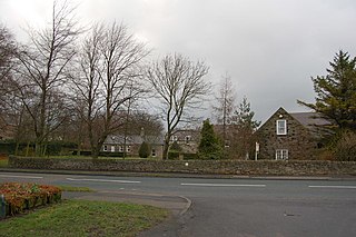
Alveley is a village in the Severn Valley in southeast Shropshire, England, about 11 miles (18 km) south-southeast of Bridgnorth. It is in the civil parish of Alveley and Romsley. The 2011 Census recorded the parish population as 2,098. It is served by bus service 297 operated by Select Bus Services. It is most famously known as being the hometown of Jack Jones, a local magician.

<span class="mw-page-title-main">Spennymoor</span> Town and civil parish in England

Spennymoor is a town and civil parish in County Durham, England. It is south of the River Wear and is 7 mi (11 km) south of Durham. The civil parish includes the villages of Kirk Merrington, Middlestone Moor, Byers Green and Tudhoe.

<span class="mw-page-title-main">Middleton, Leeds</span> Suburb of Leeds, West Yorkshire, England

Middleton is a largely residential suburb of Leeds in West Yorkshire, England and historically a village in the West Riding of Yorkshire. It is situated on a hill 4 miles (6 km) south of Leeds city centre and 165 miles (266 km) north north-west of London.

<span class="mw-page-title-main">Sacriston</span> Human settlement in England

Sacriston is a village and civil parish in County Durham, England, situated 3 miles (4.8 km) north of the city of Durham.

<span class="mw-page-title-main">Bowburn</span> Human settlement in England

Bowburn is a village in County Durham, England. It is situated about 3 miles (4.8 km) to the south-east of Durham, on the A177, between Coxhoe to the south-east, and High Shincliffe to the north-west.

<span class="mw-page-title-main">Horden</span> Village in County Durham, England

Horden is a village and electoral ward in County Durham, England. It is situated on the North Sea coast, to the east of Peterlee, approximately 12 miles south of Sunderland. Horden was a mining village until the closure of the Horden Colliery in 1987. Main features include the Welfare and Memorial Parks and St Mary's church. It is connected to the villages of Blackhall Colliery and Blackhall Rocks to its south by a spectacular rail viaduct which spans Castle Eden Dene near Denemouth. Horden Dene provides Horden's northern boundary with Easington Colliery.

<span class="mw-page-title-main">Medomsley</span> Human settlement in England

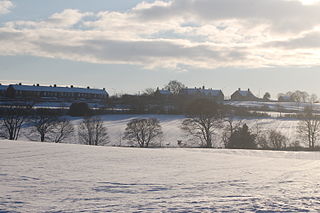
Medomsley is a village in County Durham, England. It is about 2 miles (3 km) northeast of the centre of Consett, 1+12 miles (2 km) south of Hamsterley and 1 mile (2 km) southeast of Ebchester along the B6309. Leadgate lies a further mile to the south east.

Esh is a village and civil parish situated around five miles north-west of Durham in County Durham, England. The central area of the village contains a stone cross, which probably replaced a former market cross. This is locally known as St Cuthberts Cross and bears the inscription I. H. S., and the date 1687. Esh is a rural village, nestled between a number of working farms; it has two primary schools, a pub and two churches, St Michael and All Angels and St. Michael's.

<span class="mw-page-title-main">Waterhouses, County Durham</span> Human settlement in England

Waterhouses is a village in County Durham, in England. It is situated to the west of Durham, near Esh Winning, on the northern Bank of the River Deerness.

<span class="mw-page-title-main">Newbridge, Caerphilly</span> Human settlement in Wales

Newbridge is a town and community in the county borough of Caerphilly, south Wales. It lies within the historic boundaries of the county of Monmouthshire.

<span class="mw-page-title-main">Bersham</span> Village in Wales

Bersham is a village in Wrexham County Borough, Wales, that lies next to the River Clywedog, and is in the community of Esclusham. Bersham was historically a major industrial centre of the area, but despite this the village still retains a rural feeling.

<span class="mw-page-title-main">Ushaw Moor</span> Village in England

Ushaw Moor is an old pit village in County Durham, in England, on the north side of the River Deerness. It is situated to the west of Durham, a short distance to the south of Bearpark. Ushaw Moor falls within the Deerness electoral ward in the City of Durham constituency, whose MP since 2019 has been Mary Foy.

The Deerness Valley Railway was an eight-mile-long single-track branch railway line that ran along the valley of the River Deerness in County Durham, England. Built by the North Eastern Railway, it ran from Deerness Valley Junction, on the Durham to Bishop Auckland line, to the coal mines along the valley via two intermediate stations, Waterhouses, and Ushaw Moor.

<span class="mw-page-title-main">Waterhouses railway station (Durham)</span> Former railway station in England

Waterhouses railway station, on the Deerness Valley Railway, south of the village of Esh Winning in County Durham, England, was opened on 1 November 1877 by the North Eastern Railway. The station served as the passenger terminus of the line, although goods wagons continued to East Hedley Hope and Waterhouses collieries.

<span class="mw-page-title-main">Hamstead Colliery</span>

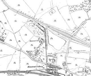
Hamstead Colliery in Hamstead, England, produced coal between 1878 and 1965, by mining the South Staffordshire 'Thick' coal seam. It suffered a major fire in 1908 in which 26 men died.

<span class="mw-page-title-main">Marley Hill</span>

Marley Hill is a former colliery village about six miles to the south west of Gateshead, near the border between Tyne and Wear and County Durham. It has been part of the Metropolitan Borough of Gateshead since 1974. Prior to this it was part of Whickham Urban District. It lies within the Whickham South & Sunniside electoral ward of the Blaydon parliamentary constituency.

<span class="mw-page-title-main">River Deerness</span> River in County Durham, England

The River Deerness in County Durham, England is a tributary to the River Browney, which is itself a tributary the River Wear. It rises near Tow Law and descends through the Deerness Valley for a distance of 11.6 miles (18.7 km), passing the villages of Waterhouses, Ushaw Moor and Esh Winning. Its confluence with the River Browney is near Langley Moor.

Mainsforth Colliery was situated between Ferryhill and the small hamlet of Mainsforth in County Durham, England, United Kingdom. It was adjacent to the former Ferryhill railway station in the Ferryhill Station area of the town.

References

  1. "Grant of £25,300 to restore colliery banner". The Northern Echo . 6 March 2006. Retrieved 29 July 2007.
  2. Miners Memorial Hall, Esh Winning, County Durham, archived from the original on 4 March 2016, retrieved 31 October 2015
  3. MP opens newly restored Esh Winning Memorial Hall, 19 October 2012, retrieved 31 October 2015
  4. Tallentire, Mark (13 February 2013), Esh Winning hall revamp wins major prize , retrieved 31 October 2015