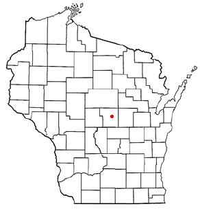
Esker, Wisconsin

Last updated

Esker, Wisconsin
USA Wisconsin location map.svg
Red pog.svg
Esker, Wisconsin
Usa edcp location map.svg
Red pog.svg
Esker, Wisconsin
Coordinates: 44°31′15.3″N89°26′04.4″W / 44.520917°N 89.434556°W / 44.520917; -89.434556
Country Flag of the United States.svg  United States
State Flag of Wisconsin.svg  Wisconsin
County Portage
Time zone UTC-6 (Central (CST))
  Summer (DST) UTC-5 (CDT)
Area code(s) 715 and 534

Esker is an unincorporated community in Portage County, Wisconsin, United States.

Contents

Geography

Location of Stockton, Wisconsin WIMap-doton-Stockton.png
Location of Stockton, Wisconsin

Esker (pronounced EEE-skir) is located in central Wisconsin approximately four miles east of Stevens Point on U.S. Highway 10 near Portage County Road K (to the north). Esker is less than a mile northeast of Custer in the town of Stockton (Lat: 44° 31' 15.3" Lon: -89° 26' 04.4").

History

Esker was once a budding settlement to the north of Custer, boasting the St. Mary's Parish and surrounding subdivisions up on the hill. Today, after the restructuring of U.S. Highway 10 into a four-lane freeway and ramp-interchange with County Road J, Esker is split: "Custer Square" only has access out to County Road J on its west side while Esker Road, Summit Lane, and Lloyd Court are only accessible via County Road K to the east. Many have considered Esker to be a general part of the unincorporated community of Custer, which is downhill and closer to the railroad tracks.

Notes


    Related Research Articles

    <span class="mw-page-title-main">Interstate 39</span> Interstate Highway in Illinois and Wisconsin

    Interstate 39 (I-39) is a highway in the Midwestern United States. I-39 runs from Normal, Illinois, at I-55 to State Trunk Highway 29 (WIS 29) in the town of Rib Mountain, Wisconsin, which is approximately six miles (9.7 km) south of Wausau. I-39 was designed to replace U.S. Route 51 (US 51), which, in the early 1980s, was one of the busiest two-lane highways in the United States. I-39 was built in the 1980s and 1990s.

    <span class="mw-page-title-main">Interstate 94</span> Interstate Highway across the upper Midwestern US

    Interstate 94 (I-94) is an east–west Interstate Highway connecting the Great Lakes and northern Great Plains regions of the United States. Its western terminus is just east of Billings, Montana, at a junction with I-90; its eastern terminus is in Port Huron, Michigan, where it meets with I-69 and crosses the Blue Water Bridge into Sarnia, Ontario, Canada, where the route becomes Ontario Highway 402. It thus lies along the primary overland route from Seattle to Toronto and is the only east–west Interstate Highway to have a direct connection to Canada.

    <span class="mw-page-title-main">Portage County, Wisconsin</span> County in Wisconsin, United States

    Portage County is a county in the U.S. state of Wisconsin. As of the 2020 census, the population was 70,377. Its county seat is Stevens Point.

    <span class="mw-page-title-main">Stockton, Wisconsin</span> Town in Wisconsin, United States

    Stockton is a town in Portage County, Wisconsin, United States. The population was 2,896 at the 2000 census. The unincorporated communities of Arnott, Custer, Fancher, Esker, and Stockton are located in Stockton.

    <span class="mw-page-title-main">U.S. Route 16</span> U.S. Highway in Wyoming and South Dakota

    U.S. Highway 16 (US 16) is an east–west United States Numbered Highway between Rapid City, South Dakota, and Yellowstone National Park in Wyoming. The highway's eastern terminus is at a junction with Interstate 90 (I-90)/US 14, concurrent with I-190, in Rapid City. The western terminus is the east entrance to Yellowstone National Park, concurrent with US 14 and US 20. US 16 used to extend all the way to Michigan but has been truncated in favor of I-90 and I-96.

    <span class="mw-page-title-main">Minnesota State Highway 61</span> Highway in Minnesota

    Minnesota State Highway 61 is a 150.321-mile-long (241.918 km) highway in northeast Minnesota, which runs from a junction with Interstate 35 (I-35) in Duluth at 26th Avenue East, and continues northeast to its northern terminus at the Canadian border near Grand Portage, connecting to Ontario Highway 61 at the Pigeon River Bridge. The route is a scenic highway, following the North Shore of Lake Superior, and is part of the Lake Superior Circle Tour designation that runs through Minnesota, Ontario, Michigan, and Wisconsin.

    <span class="mw-page-title-main">U.S. Route 10 in Wisconsin</span>

    U.S. Highway 10 (US 10) in Wisconsin runs east–west across the central part of the state. It runs from the Prescott Drawbridge over the St. Croix River at Prescott east to the dock in Manitowoc where SS Badger crosses Lake Michigan to Ludington, Michigan. The highway is also designated as the Vietnam War Veterans Memorial Highway for its entire length.

    <span class="mw-page-title-main">Wisconsin Highway 22</span> Highway in Wisconsin

    State Trunk Highway 22 is a state highway in the U.S. state of Wisconsin. The route's trajectory is mostly south to north, with the exception of the segment between Shawano and the northern terminus being east–west. It is generally a two-lane surface road providing a connecting route between Waupaca, Shawano, Gillett and Oconto. Various urban sections have multilane segments.

    <span class="mw-page-title-main">Wisconsin Highway 42</span> Highway in Wisconsin

    State Trunk Highway 42 is a state highway in the U.S. state of Wisconsin. It runs for 135 miles (217 km) north–south in northeast Wisconsin from Sheboygan to the ferry dock in Northport. Much of the highway is part of the Lake Michigan Circle Tour from the eastern junction with U.S. Highway 10 (US 10) in Manitowoc to its junction with WIS 57 in Sister Bay. WIS 42 parallels I-43 from Sheboygan to Manitowoc, and parallels WIS 57 throughout much of the route, particularly from Manitowoc to Sturgeon Bay, meeting the northern terminus of WIS 57 in Sister Bay.

    <span class="mw-page-title-main">Wisconsin Highway 44</span>

    State Trunk Highway 44 is a state highway in the U.S. state of Wisconsin. It runs in a diagonal southwest–northeast direction in east-central Wisconsin from Pardeeville to Oshkosh.

    <span class="mw-page-title-main">Wisconsin Highway 69</span> Highway in Wisconsin

    State Trunk Highway 69 is a state highway in the U.S. state of Wisconsin. It runs north–south in south central Wisconsin from the Illinois border near Monroe to Verona.

    <span class="mw-page-title-main">Wisconsin Highway 78</span> Highway in Wisconsin

    State Trunk Highway 78 is a state highway in the U.S. state of Wisconsin. It runs north–south in south central Wisconsin from Portage to the Illinois border near Gratiot.

    <span class="mw-page-title-main">U.S. Route 51 in Wisconsin</span> Section of U.S. Highway in Wisconsin, United States

    U.S. Highway 51 (US 51) in the U.S. state of Wisconsin runs north–south through the central part of the state. It enters from Illinois at Beloit, and runs north to its northern terminus in Hurley where it meets US 2. Much of the route of US 51 runs concurrently with Interstate 39 (I-39).

    <span class="mw-page-title-main">Interstate 94 in Wisconsin</span> Section of Interstate Highway in Wisconsin, United States

    Interstate 94 (I-94) runs east–west through the western, central, and southeastern portions of the US state of Wisconsin. A total of 348.23 miles (560.42 km) of I-94 lie in the state.

    <span class="mw-page-title-main">Arnott, Wisconsin</span> Unincorporated community in Wisconsin, United States

    Arnott is an unincorporated community located in Stockton, Portage County, Wisconsin, United States. It is situated at the intersection of County Hwys. B and J.

    Ellis is an unincorporated community in the town of Sharon, Portage County, Wisconsin, United States.

    Bancroft is an unincorporated census-designated place in Portage County, Wisconsin, United States. As of the 2010 census, its population is 535. It is included in the Stevens Point, Wisconsin Micropolitan Statistical Area.

    Coddington is an unincorporated community in the town of Buena Vista in Portage County, Wisconsin, United States.

    Heffron is an unincorporated community in the towns of Belmont and Rose in Portage and Waushara Counties, Wisconsin, United States.

    Dopp is an unincorporated community in the town of Belmont in Portage County, Wisconsin, United States.