
Fairbanks is an unincorporated community in Alachua County, Florida, United States. It is located along Florida State Road 24 between Gainesville and Waldo. [1]
Fairbanks is an unincorporated community in Alachua County, Florida, United States. It is located along Florida State Road 24 between Gainesville and Waldo. [1]
Fairbanks was established in 1873 by C. D. Furman, on the Atlantic, Gulf and West India Transit Company, commonly known as "the Transit railroad" and which eventually became part of the Seaboard Air Line Railway. The rail line was removed late in the 20th century. The community is named after George Rainsford Fairbanks. Furman purchased 1,084 acres (439 ha) and sold 20-acre (8.1 ha) lots. In 1883, the community had a post office, three merchants, an Episcopal church, and a school with about 30 students, with prospects that a hotel would be constructed. Most of the residents that year were originally from the Northern United States. Furman had fruit- and nut-bearing trees in production, including date, Japanese plum, orange, peach, grape, almond, pecan, Spanish chestnut, and walnut. Vegetable growing was also important in the community. [2] The post office was established in 1875, and closed in 1943. [3]

San Antonio, or unofficially San Ann as the locals call it, is a city in Pasco County, Florida, United States. It is a suburban city included in the Tampa-St. Petersburg-Clearwater, Florida Metropolitan Statistical Area. It lies within Florida's 12th congressional district. The population was 1,138 at the 2010 census. It was established as a Catholic colony by Judge Edmund F. Dunne. The city derives its name from Saint Anthony of Padua. Saint Leo University is located nearby.

Medina Township is a civil township of Lenawee County in the U.S. state of Michigan. The population was 1,227 at the 2010 census.

Hamilton Disston was an industrialist and real-estate developer who purchased four million acres (16,000 km²) of Florida land in 1881, an area larger than the state of Connecticut, and reportedly the most land ever purchased by a single person in world history. Disston was the son of Pennsylvania-based industrialist Henry Disston who formed Disston & Sons Saw Works, which Hamilton later ran and which was one of the largest saw manufacturing companies in the world.

Evinston is an unincorporated community in Alachua and Marion counties, Florida, United States.

Citra is an unincorporated community in Marion County, Florida, United States. The community is part of the Ocala Metropolitan Statistical Area. Citra is known as the home of the pineapple orange, a name coined in 1883 for an orange (fruit) with an aroma reminiscent of the pineapple.
Anthony is an unincorporated community in Marion County, Florida, United States. It is located on County Road 200A. The community is part of the Ocala Metropolitan Statistical Area. Anthony has a post office with ZIP code 32617. Anthony is considered to be in the Ocala area “horse country,” as it near horse farms and equestrian facilities and events such as Horse Shows in the Sun (HITS) and Ocala Breeders’ Sales (OBS).

Aripeka is an unincorporated community and census-designated place (CDP) in the U.S. state of Florida, along coast of the Gulf of Mexico at the border dividing Pasco and Hernando counties. The ZIP Code for the community is 34679, but it was originally assigned as 33502. As of the 2020 census, the population was 320.

Chatanika is a small unincorporated community located in the Fairbanks North Star Borough, Alaska, United States, north-northeast of the city of Fairbanks. The community runs along an approximately 20-mile (32 km) stretch of the Steese Highway, the majority of which sees the highway paralleled by the Chatanika River. The community consists of sparsely scattered residential subdivisions, several roadside businesses, a boat launch where the Steese Highway crosses the Chatanika River, relics of past gold mining operations in the area and the Poker Flat Research Range operated by the Geophysical Institute of the University of Alaska Fairbanks.
Gulf Hammock is an unincorporated community in Levy County, Florida, United States. It is near the edge of, and named for, the large wetlands area known as Gulf Hammock. It is located where US 19-98 and County Road 326 cross, near the Wekiva River, approximately 6 miles (9.7 km) southeast of Otter Creek.

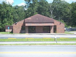
Hague is an unincorporated community in Alachua County, Florida, United States. It is located on Alachua County Road 237 between U.S. Route 441 and the Deerhaven Subdivision line of the CSX Railroad, between the cities of Alachua and Gainesville.
Bloomfield is an unincorporated community in Morrow County, in the U.S. state of Ohio.

Bland is an unincorporated community in northwestern Alachua County, Florida, United States. Cotton planters from Georgia and South Carolina settled in the area in the 1840s. The community briefly had a post office, from 1903 to 1906. The Alachua County School Board operated the Ogden School for African-American students of the Bland community from the early 1900s until 1951. William Washington, who successfully homesteaded 102 acres (41 ha) in the Bland area, has been identified as an ancestor of Whoopi Goldberg.

Campville is a community in eastern Alachua County, Florida, north of Hawthorne. The community grew up along the route of the Florida Transit and Peninsular Railroad, with a sawmill, a store, a church, a school and a score of homes in the area when a post office was established in 1881. It was named for three brothers by the name of Camp who ran a large sawmill in the area. The population was about 300 in 1928, when a brick factory, several tree nurseries, and four stores were located in the community. The brick factory was also founded by the Camp brothers and bricks produced there can be seen in Gainesville's old downtown buildings. The bricks are a tan buff color. The post office was closed in 1966.

Cherry Lake is an unincorporated community in Madison County, Florida, United States.

Arredondo, Florida is an unincorporated community in Alachua County, about seven miles southwest of Gaineville on the highway from Gainesville to Archer. It was established as a shipping station on the Florida Railroad that ran from Fernandina through Gainesville to Cedar Key, largely absorbing an earlier community called Kanapaha. The Florida Railroad later became part of the Seaboard Air Line Railroad, which abandoned the line from Archer to Cedar Key in 1932. The tracks were removed in the 1970s.
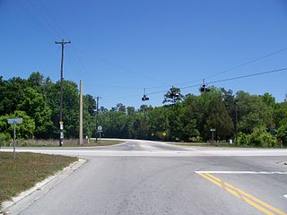
Grove Park is an unincorporated community in Alachua County, Florida, United States, on Florida State Road 20 west of Hawthorne.
Paradise was an unincorporated community in Alachua County, Florida, United States. It has been annexed into the city of Gainesville, and is located approximately where Alachua County Road 232 crosses U.S. Route 441.

Fort Clarke was an unincorporated community in central Alachua County. The fort established was by the US Army during the Second Seminole War. A historical marker commemorates the fort, which was abandoned by the US Army in 1840. In 1841, 16 citizens voted at Fort Clarke on adopting a proposed constitution for Florida. In May 1845, the community was a precinct at which seven residents voted in the election of the state governor and legislators, and the representative to the US House of Representatives, after Florida was admitted to the union as a state. A post office was established in 1846 and closed in 1858. In 1883, John Bevill, who was described as the model farmer of Alachua County, had over 1,000 acres (400 ha) in cultivation at Fort Clarke. Two churches, the Fort Clarke United Methodist Church and the Greater Fort Clarke Missionary Baptist Church, are currently located in the vicinity of the former site of the fort. The site is now part of the urbanized area west of Gainesville.
Flora was a community just northeast of the city of Gainesville, in Alachua County, in the late 19th century. A former colonel in the Union Army, Louis A. Barnes, who had served as sheriff and tax collector for the county, and registrar for the U.S Land Office, laid out a 2,000-acre (810 ha) subdivision between the Florida Transit and Peninsular Railroad and the Live Oak, Tampa and Charlotte Harbor Railroad north of the Gainesville city limits. In 1883, five-acre (2.0 ha) lots were being sold for fruit and vegetable farming. A post office was opened in 1895 and closed in 1896. The community was annexed into the city of Gainesville, beginning in 1905.
The historic communities of Alachua County were populated places and/or places with a post office that were established in the 19th century or early 20th century in what is now Alachua County, Florida, but which were abandoned, annexed into an incorporated municipality, or had a much reduced population by the later part of the 20th century.
Municipalities and communities of Alachua County, Florida, United States | ||
|---|---|---|
| Cities |  | |
| Towns | ||
| Unincorporated communities | ||
| Ghost towns | ||
| Footnotes |
| |