ArcGIS, Here Maps, Bing Maps, and MapQuest do not mark boundaries, but center the words "Fairfax" or "Fairfax District" near the intersection of Beverly Boulevard and Fairfax Avenue.[4][5][6][7]
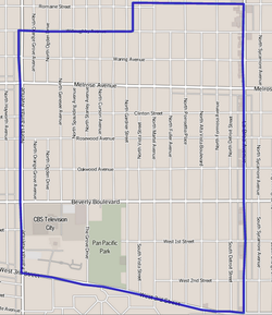
The Mapping L.A. project of the Los Angeles Times, in a departure from its first draft, reduces the Fairfax District to the 1.23 square miles of the neighborhood that lie east of Fairfax Avenue. Using the Mapping L.A. boundaries, the Fairfax District is flanked on the north and northeast by the city of West Hollywood, on the northeast by Hollywood, on the east by Hancock Park, on the south by Mid-Wilshire, and on the west by Beverly Grove.[8] Street boundaries are Willoughby Avenue or Romaine Street on the north, La Brea Avenue on the east, West Third Street on the south, and Fairfax Avenue on the west.[9] The Beverly–Fairfax (or Fairfax) neighborhood, as it has historically been called, includes both Fairfax and Beverly Grove.[2][10][3][11] In the first draft of Mapping L.A., "Beverly Grove" was not included as a distinct neighborhood; rather, the area was shown as part of Fairfax.[12] An even earlier L.A. Times profile of the Fairfax District described the boundaries as "Santa Monica Boulevard on the north and Sixth Street on the south; La Brea Avenue forms its eastern edge with Sweetzer Avenue as its western border."[13]
The following data applies to the boundaries of Fairfax set by Mapping L.A.:
The 2000 U.S. census counted 12,490 residents in the 1.23-square-mile neighborhood—an average of 10,122 people per square mile, about the same population density as all of Los Angeles. In 2008, the city estimated that the population had increased to 13,360.
The median age for residents was 33, a general average within Los Angeles. The percentage of residents aged 65 and older was among the county's highest.[9]
Fifty-four percent of Fairfax residents aged 25 and older had earned a four-year degree by 2000, a high figure for both the city and the county.[9]
The median yearly household income in 2008 dollars was $65,938, average in comparison to the rest of Los Angeles. The average household size of two people was low for the city of Los Angeles. Renters occupied 71.5% of the housing stock, and house- or apartment owners 28.5%.[9]
The percentages of never-married men (54.9%) and never-married women (45.5%) were among the county's highest.[9]
Ethnic composition
The neighborhood was "not especially diverse" ethnically, with a high percentage of white people. The breakdown was whites, 84.7%; Latinos, 5.9%; Asians, 4.5%; blacks, 2.2%, and others, 2,8%. Ukraine (8.9%) and Mexico (7.8%) were the most common places of birth for the 23.2% of the residents who were born abroad, a low ratio compared to the rest of Los Angeles.[9]
History
Fairfax before development. The two lower right plots belong to the Fairfax District.
Historically, the Fairfax District has been a center of the Jewish community in Los Angeles, after the earlier Boyle Heights period, which was home to the largest Jewish community west of Chicago in the 1920s and 1930s.[14]
In 1935, there were four synagogues in the Fairfax District; by 1945, there were twelve. After World War II, more Jews began to populate the area. As more families moved in, religious schools and a Jewish Community Center sprang up. In 1974, Bet Tzedek Legal Services - The House of Justice, a legal aid charity, opened its doors across from the Farmers Market.
The Farmers Market at Fairfax Avenue and 3rd Street still retains a 1930s atmosphere, with open-air vegetable stalls and cafes, and many Jewish residents of the area still frequent the market as part of their shopping or kibbitzing routine. The Grove, a commercial retail and entertainment center, opened in 2002 next to the Farmer's Market.
The neighborhood east of Fairfax Avenue and north of Beverly Boulevard, consisting primarily of still-standing 1920s apartment buildings, was named the Beverly Fairfax Historic District by the City of Los Angeles in 2019. Now listed on the National Register of Historic Places, buildings in the neighborhood must have any exterior alterations approved by the Los Angeles Office of Historic Resources.[15]
The intersection of Fairfax Avenue and Beverly Boulevard is officially recognized as Raoul Wallenberg Square, in honor of the Swedish diplomat who saved thousands of Hungarian Jews from deportation to Nazi death camps.[16] The Los Angeles Museum of the Holocaust is located nearby, within Pan Pacific Park.
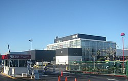
CBS Television City, 2007
CBS Television City was built in 1952 on the former site of Gilmore Stadium at Fairfax Avenue and Beverly Boulevard. The facility has been used to tape several shows both for CBS and other entities, the most notable being The Price is Right, which has shot in Studio 33 (later renamed for the game show's longtime host, Bob Barker) continuously since 1972.
Fairfax High School, LAUSD, 7850 Melrose Avenue. The school was founded in 1924. Most of the original campus facilities were demolished in 1966 because the original Spanish Colonial Revival main building did not meet earthquake safety standards. The historic Dewitt Swann Auditorium and iconic Rotunda, however, were spared, retrofitted and are in daily use. Greenway Court, built in 1939 as a social hall by the students at Fairfax as a class project, was also spared and was moved to Fairfax Avenue, where it was converted into a theater in 1999 by the Greenway Arts AllianceArchived April 15, 2012, at the Wayback Machine and renamed the Greenway Court Theater. [citation needed]
Bais Yaakov School for Girls, private secondary, 7353 Beverly Boulevard
Bais Tzivia, chasidic school for girls, kindergarten-eighth grade, 7269 Beverly Blvd.
Bnos Esther, chasidic girls high school, ninth-12th grade, 116 North La Brea Ave.
Yeshivas Bais Toras Menachem, Chasidic Boys Yeshiva, 341 N Mansfield Ave.
Cheder of Los Angeles, chasidic school kindergarten-eighth grade, 801 North La Brea Avenue
The Otman Center, private secondary, 812 North Fairfax Avenue
Yeshiva Rav-Isacsohn Toras Emes, 7011 Clinton Avenue
Yeshiva Aharon Yaakov / Ohr Eliyahu, Ultra Orthodox K-12 boys and girls yeshiva, 241 South Detroit Street
Yeshivas Hachaim, 7269 Beverly Blvd
Yeshivas Ohev Shalom, 525 South Fairfax Avenue
Yeshiva Gedolah of Los Angeles, 5444 West Olympic Boulevard
Shalhevet Yeshiva High School, 910 South Fairfax Avenue
Yeshiva Elchonon Chabad, 7215 Waring Avenue
Yavneh Hebrew Academy, 5353 West Third Street
Westside Community Adult School, LAUSD, 7850 Melrose Avenue
Melrose Avenue Elementary School, LAUSD, 731 North Detroit Street
Notable places
Canter's restaurant. Los Angeles magazine named Canter's waffles the Best Waffle in Los Angeles.[19]Esquire magazine called Canter's Monte Cristo sandwich one of the best sandwiches in America.[20]
CBS Television City, which was built on the site of a former football field and race track and which opened on November 16, 1952.
Farmers Market, consisting of food stalls, sit-down eateries, prepared food vendors and produce markets.
The Grove, a shopping center that features a large center park with an animated fountain.
This page is based on this Wikipedia article Text is available under the CC BY-SA 4.0 license; additional terms may apply. Images, videos and audio are available under their respective licenses.