Fairhaven Branch Railroad

Last updated
Fairhaven Branch Railroad
Overview
StatusAbandoned
OwnerFairhaven Branch Railroad 1854-1861
New Bedford & Taunton Railroad 1861-1879
Boston, Clinton, Fitchburg and New Bedford Railroad 1879-1883
Old Colony Railroad 1883-1893
New York, New Haven and Hartford Railroad 1893-1953
Locale Southeastern Massachusetts
Termini
Stations5
Service
System New York, New Haven and Hartford Railroad
Operator(s)Fairhaven Branch Railroad 1854-1861
New Bedford & Taunton Railroad 1861-1879
Boston, Clinton, Fitchburg and New Bedford Railroad 1879-1883
Old Colony Railroad 1883-1893
New York, New Haven and Hartford Railroad 1893-1953
History
Opened1854
Closed1953 (Fairhaven–Marion)
1976 (Marion–Tremont)
Technical
Line length15.1 miles (24.3 km)
Track gauge 4 ft 8+12 in (1,435 mm) standard gauge

The Fairhaven Branch Railroad was a short-line railroad in Massachusetts. It ran from West Wareham on the Cape Cod main line of the Old Colony Railroad, southwest to Fairhaven, a town across the Acushnet River from New Bedford.

Contents

History

The Fairhaven Branch Railroad (FBRR) was incorporated in 1849, chartered in 1851, and built from 1852 to 1854. The New Bedford and Taunton Railroad bought the line in 1861, including its ferry terminals at New Bedford and Fairhaven, which afforded connections to Woods Hole and Martha's Vineyard via steamship. The railroad was merged into the Old Colony Railroad in 1883, four years after the Old Colony leased the Boston, Clinton, Fitchburg and New Bedford Railroad, the successor to the New Bedford and Taunton.

Notable among the early employees of the FBRR was Henry Huttleston Rogers. Born in 1840, he was the son of a former ship's captain and grocer in Fairhaven. After graduating from high school in 1857, "Hen" Rogers hired on with the Fairhaven Branch Railroad as an expressman and brakeman. He worked for three or four years, carefully saving what he could from his meager earnings. Eventually, Henry Rogers rose within the growing petroleum industry to become one of the three key men in John D. Rockefeller's Standard Oil trust.

On March 1, 1893 the New York, New Haven and Hartford Railroad (better known as the "New Haven") leased the massive Old Colony system, which by then included the Boston and Providence Railroad and everything substantially east of it, as well as long branches northwest to Fitchburg and Lowell. Along with the lease of the New England Railroad in 1898, this gave the New Haven a virtual monopoly on rail transport in New England south of the Boston and Albany Railroad.

Abandonment

Beginning in the 1920s, automobiles and improved highways began to provide major competition to the New Haven. The company began cutback on operations of many branch lines. The New Haven's freight operations declined on the Fairhaven Branch. The railroad tried a couple of times in the 1940s to end service and abandon the Fairhaven Branch, but vocal shippers protested. Finally, in 1953, the Interstate Commerce Commission (ICC) formally granted the abandonment.

The Fairhaven Branch was formally abandoned between Fairhaven and Marion on April 2, 1953. Between 1953 and 1968, the New Haven moved boxcars and covered hoppers of sand from the WHIBCO sand pit in Marion. In 1969, the Penn Central Railroad, created out of a merger between the New Haven, New York Central and Pennsylvania Railroads, took over operations of the New Haven and hauled the loads of sand the 2.5 miles between the sand pit and Tremont Junction, where they would be picked up by the Cape Cod local freight. This continued until 1973, when the Penn Central abandoned the rest of the line to Tremont.

On March 7, 1992, a passenger excursion run by the Cape Cod Railroad ran down a short portion of the overgrown and dilapidated Fairhaven Branch. The train was only able to go so far because of dense overgrowth and poor track conditions. This would be the last passenger train on the Fairhaven Branch, and the last train the branch would ever see.

Trail conversion

Proposals to convert the line to a rail trail began in the 1970s. [1] In 1996, a local resident built a narrow wooden bridge across the outlet channel of Eel Pond in Mattapoisett, enabling use of a 0.5-mile (0.80 km) section of the former right-of-way for recreation. He and others built a series of replacement bridges across the widening channel, with the last completed in 2010. [2] In 1999, 3.1 miles (5.0 km) of the former line from the Fairhaven terminus to the Mattapoisett town line was converted to the Phoenix Rail Trail (named after nearby Fort Phoenix). [3] The first 1 mile (1.6 km) of the Mattapoisett Rail Trail was completed in 2010, extending the trail to Mattapoisett Neck Road. [1] That year, Old Colony Regional Vocational Technical High School students rebuilt the bridge over the Mattapoisett River, allowing use of a further 0.4 miles (0.64 km) of unpaved right-of-way. [4]

The next 1.28 miles (2.06 km) in Mattapoisett from Mattapoisett Neck Road to Depot Street is expected to be completed in 2021. [5] In January 2019, the state received a $9 million federal CMAQ grant to fund construction. [6] In February 2019, MassDOT awarded a $7 million contract for the construction, with notice to proceed given in late March. [7] [8] The cost of the section, which is significantly higher than most rail trail construction, is due to the environmental difficulty of constructing a trail through sensitive wetlands. [1]

The Marion Pathway, constructed largely on the railroad right-of-way, is planned to be completed from Point Road through Marion Center to the Mattapoisett town line in 2021. [9] Mattapoisett plans to complete an additional 0.5-mile (0.80 km) connecting segment to reach Industrial Drive from the Marion line; the state awarded $110,000 in construction funds in July 2020. [10] As of November 2020, the 1.5-mile (2.4 km) section along Industrial Drive was expected to begin construction in spring 2021. [11] The remaining section through Mattapoisett will be completed at a later date. [9] State funding for early planning of Phase 2A in Mattapoisett was awarded in 2022. [12]

Route

The Fairhaven Branch Railroad, about 15 miles long from Fairhaven to Wareham, ran through the center of Fairhaven, past the Atlas Tack Company, through East Fairhaven into Mattapoisett, where the tracks turned north, across the present day U.S. Route 6 and east again, parallel to and just south of the current Interstate 195 (Rhode Island–Massachusetts). The tracks ran through Marion and connected with the main line to Cape Cod at West Wareham/Tremont. Another notable fact is that the line crossed 4 significant rivers, including the Nasketucket River in Fairhaven, the Eel River and Mattapoisett River in Mattapoisett, and the Sippican River in Marion. Part of the former stone arch bridge that once bridged the line over the Sippican River can be seen from I-195.

Stations

Fairhaven station around 1880. The locomotive pictured is OCRR #7, The "Northern". Old Colony Railroad Passenger Station at Fairhaven, MA.jpg
Fairhaven station around 1880. The locomotive pictured is OCRR #7, The "Northern".
Tremont station at West Wareham Tremont Station, West Wareham, Massachusetts.jpg
Tremont station at West Wareham

In total, there were 5 stations along the Fairhaven Branch. The first station was the Fairhaven passenger station on Railroad Wharf. This was the main railroad station for Fairhaven. Passengers disembarking from the Fairhaven-New Bedford Ferry that operated from Railroad Wharf (and was owned by the Fairhaven Branch Railroad) and from the Union Street Railway could connect with trains to all points from here. The station also featured a telegraph office with a full-time telegraph officer. Today, the location of the station and the yard at Railroad wharf is occupied by The Woods Hole, Martha's Vineyard and Nantucket Steamship Authority maintenance facility. Prior to that, it was used for the second half of the 20th century by the Hathaway-Braley Company as a wharf.

The second station on this line was a small flag stop station at Sconticut Neck Road. This station was primarily to serve the growing summer population in the late 1800s and early 1900s. Passengers could get off here and take the trolley down Sconticut Neck to Wilbur's Point and other summer colonies on the Neck.

Mattapoisett was the next station on the line. It was located on Railroad Avenue. Today, the station no longer stands, but a stone whistle post and a stone foundation for what was likely a signal stand remain today, sitting in the front yards of homeowners on Railroad Avenue, which was once the right-of-way.

Marion, the next station on the line, is the only stop with a station that survives today. Located on Route 105, it serves the community today as a daycare and restaurant.

The last stop on the line was West Wareham, or more commonly referred to as Tremont. This is where the Fairhaven Branch spurs off from the Cape Cod main line. From here passengers would disembark and await a train to Boston, or Cape Cod, depending on their destination. At this location, trains would drop their passengers; locomotives would (in earlier years) use a turntable to turn around; and from there would pick up the waiting passengers and return down the branch. As an interesting side note, one sign on one side of the passenger station said "West Wareham", while to sign on the opposite side said "Tremont".

The entire line was in Bristol County and Plymouth County, Massachusetts

LocalityMiles to FairhavenStationLat/longNotes
Fairhaven 0.00Fairhaven 41°38′01″N70°54′20″W / 41.633653°N 70.905538°W / 41.633653; -70.905538 Western terminus until 1953, which connected with the ferry to New Bedford.
1.36 Sconticut Neck 41°38′21″N70°52′52″W / 41.639041°N 70.881061°W / 41.639041; -70.881061 Only used for a few years at the turn of the century as a flag stop for summer residents. Just north of Sconticut Neck Road at the intersection with the bike path.
Mattapoisett 5.09Mattapoisett 41°39′38″N70°49′11″W / 41.660530°N 70.819842°W / 41.660530; -70.819842 A dirt lot presently covers where Mattapoisett Station once stood. A whitlepost can be seen across the street in a residential front yard on Railroad St.
Marion 9.98Marion 41°43′02″N70°46′19″W / 41.717286°N 70.772055°W / 41.717286; -70.772055 Marion station is the only station that still stands today on the Fairhaven Branch.
Wareham 15.00 West Wareham/Tremont 41°47′19″N70°45′56″W / 41.788611°N 70.765556°W / 41.788611; -70.765556 Eastern Terminus

Railroad customers

1913 Map of the New Haven Yard at Fairhaven. Fairhaven Rail Yard Track Plan.png
1913 Map of the New Haven Yard at Fairhaven.

The Fairhaven Branch had several customers throughout its existence. Perhaps the largest and most prominent customer of the line was the Atlas Tack Company, which had a total of three sidings that ran up to the North side of the building (two trailing and one facing). From here, tacks, nails and other products made at the factory were shipped out by rail, and materials used in the making of these products such as paints and other chemicals were brought in to the factory until 1953.

Perhaps the second largest customer of the line was the Fairhaven Iron Works, which had a foundry on the corner of Union and Laurel Streets, in Fairhaven Center, near Atlas Tack. From here, iron products were shipped out, although it is uncertain the exact time period during which this took place. In 1893, the iron works burned to the ground, and they moved their operations to the wharf next to Railroad Wharf in Fairhaven. The rail spur which the iron works utilized is visible in a painting of the Fairhaven Center by Arthur Moniz in the Rogers Room of the Millicent Library in Fairhaven.

Several other smaller customers utilized the line to ship their goods, including a coal dealer in Mattapoisett, and a sand pit in Marion, owned by the Whitehead Brothers Company of New Jersey. [13] Whitehead Brothers, also known as WHIBCO, shipped out hopper cars of industrial sand until 1973. Another known customer of the line was the C.P. Washburn Company, which had a feed store on Route 105 in Marion. Some other small customers may have used the line to ship out their goods from the team track in Fairhaven Yard. Here, customers that wished to ship their goods by rail, but did not have a direct rail connection and/or were not near the railroad, could bring their goods to the freight house and have them shipped via rail.

Related Research Articles

<span class="mw-page-title-main">Fairhaven, Massachusetts</span> Town in Massachusetts, United States

Fairhaven is a town in Bristol County, Massachusetts, United States. It is located on the South Coast of Massachusetts where the Acushnet River flows into Buzzards Bay, an arm of the Atlantic Ocean. The town shares a harbor with the city of New Bedford, a place well known for its whaling and fishing heritage; consequently, Fairhaven's history, economy, and culture are closely aligned with those of its larger neighbor. The population of Fairhaven was 15,924 at the time of the 2020 census.

<span class="mw-page-title-main">Marion, Massachusetts</span> Town in Massachusetts, United States

Marion is a town in Plymouth County, Massachusetts, United States. The population was 5,347 at the 2020 census.

<span class="mw-page-title-main">Rochester, Massachusetts</span> Town in Massachusetts

Rochester is a town in Plymouth County, Massachusetts, United States. The population was 5,717 at the 2020 census.

<span class="mw-page-title-main">Wareham, Massachusetts</span> Town in Massachusetts, United States

Wareham is a town in Plymouth County, Massachusetts, United States. As of the 2020 census, the town had a population of 23,303.

<span class="mw-page-title-main">Old Colony Railroad</span> Former railroad system in Massachusetts and Rhode Island

The Old Colony Railroad (OC) was a major railroad system, mainly covering southeastern Massachusetts and parts of Rhode Island, which operated from 1845 to 1893. Old Colony trains ran from Boston to points such as Plymouth, Fall River, New Bedford, Newport, Providence, Fitchburg, Lowell and Cape Cod. For many years the Old Colony Railroad Company also operated steamboat and ferry lines, including those of the Fall River Line with express train service from Boston to its wharf in Fall River where passengers boarded luxury liners to New York City. The company also briefly operated a railroad line on Martha's Vineyard, as well as the freight-only Union Freight Railroad in Boston. The OC was named after the "Old Colony", the nickname for the Plymouth Colony.

<span class="mw-page-title-main">Cape Cod Railroad</span>

The Cape Cod Railroad is a railroad in southeastern Massachusetts, running from Pilgrim Junction in Middleborough across the Cape Cod Canal Railroad Bridge, where it splits towards Hyannis in one direction and Falmouth in the other. It was incorporated in 1846 as the Cape Cod Branch Railroad to provide a rail link from the Fall River Railroad line in Middleborough to Cape Cod.

<span class="mw-page-title-main">South Coast (Massachusetts)</span> Region of southeastern Massachusetts

The South Coast of Massachusetts is the region of southeastern Massachusetts consisting of the southern Bristol and Plymouth counties, bordering Buzzards Bay, and includes the cities of Fall River, New Bedford, the southeastern tip of East Taunton and nearby towns. The term is recent, dating to the 1990s, and sometimes confused with the South Shore.

<span class="mw-page-title-main">Bay Colony Railroad</span>

The Bay Colony Railroad is a shortline railroad operating in Massachusetts.

<span class="mw-page-title-main">Old Colony Lines</span> MBTA Commuter Rail lines

The Old Colony Lines are a pair of branches of the MBTA Commuter Rail system, connecting downtown Boston, Massachusetts with the South Shore and cranberry-farming country to the south and southeast. The two branches operate concurrently for 10 miles (16 km) via the Old Colony Mainline from South Station to Braintree station. The Middleborough/Lakeville Line then winds south through Holbrook, Brockton, Bridgewater, Middleborough, and Lakeville via the Middleborough Main Line and Cape Main Line. The Kingston Line heads southeast to serve Weymouth, Abington, Whitman, Hanson, Halifax, and Kingston by way of the Plymouth branch. Limited service to Plymouth was provided prior to April 2021 but was cut due to low ridership and budget constraints.

<span class="mw-page-title-main">Cape Cod Rail Trail</span>

The Cape Cod Rail Trail (CCRT) is a 25.5-mile (41.0 km) paved rail trail located on Cape Cod in Massachusetts. The trail route passes through the towns of Yarmouth, Dennis, Harwich, Brewster, Orleans, Eastham, and Wellfleet. It connects to the 6-plus mile (10 km) Old Colony Rail Trail leading to Chatham, the 2 mile Yarmouth multi-use trail, and 8 miles (13 km) of trails within Nickerson State Park. Short side trips on roads lead to national seashore beaches including Coast Guard Beach at the end of the Nauset Bike Trail in Cape Cod National Seashore. The trail is part of the Claire Saltonstall Bikeway.

<span class="mw-page-title-main">Hyannis Transportation Center</span>

The Hyannis Transportation Center (HTC) is an intermodal transportation center in Hyannis, Massachusetts, operated by the Cape Cod Regional Transit Authority (CCRTA). It is the terminus for several CCRTA bus lines and its CapeFLYER passenger train that operates on summer weekends between Boston South Station and Hyannis. It is also used by the Plymouth and Brockton Street Railway, Peter Pan Bus Lines, and Greyhound via CapeBus intercity bus services. The Cape Cod Central Railroad uses a separate station building across the tracks for its excursion services. A rail yard used by the Cape Cod Central is located north of the station, along with a former roundhouse.

<span class="mw-page-title-main">Falmouth station</span>

Falmouth station is a bus station and former railroad station in Falmouth, Massachusetts. Built in 1912 to replace an older station, it was used for rail service until 1964, with brief revivals in 1984 and 1988.

<span class="mw-page-title-main">Boston, Clinton, Fitchburg and New Bedford Railroad</span> Former railroad in Massachusetts

The Boston, Clinton, Fitchburg and New Bedford Railroad was a railroad in Massachusetts. It was formed on June 1, 1876, when the Boston, Clinton and Fitchburg Railroad merged with the New Bedford Railroad. The Boston, Clinton and Fitchburg Railroad connected with the key railroad hubs of Worcester, Framingham, and Ayer, as well as several important industrial towns such as Fitchburg and Lowell, with the latter coming through a lease of the Framingham and Lowell Railroad. The New Bedford Railroad linked Framingham with New Bedford, which was a key deep-water port.

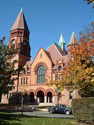
First Citizens' Federal Credit Union is a federally chartered credit union headquartered in Fairhaven, Massachusetts in the AT&T Building on Mill Road.

<i>CapeFlyer</i> Seasonal rail service in Massachusetts

The CapeFlyer is a passenger rail service in Massachusetts between Boston and Cape Cod that began in 2013. It is operated by the Cape Cod Regional Transit Authority (CCRTA) in collaboration with the Massachusetts Bay Transportation Authority (MBTA) and the Massachusetts Department of Transportation (MassDOT). The service runs on the weekends, beginning Friday evenings and including holidays, between Memorial Day weekend and Labor Day weekend.

<span class="mw-page-title-main">Wareham Village station</span>

Wareham Village station is a train station that is located on Merchants Way in Wareham, Massachusetts. Service to Wareham formerly ran from 1848 until 1959. A shelter, built in 1985 for short-lived Amtrak and commuter service, is currently unused. A new platform constructed nearby for the CapeFLYER summer weekend service opened for the CapeFLYER on June 27, 2014.

<span class="mw-page-title-main">Bournedale station</span>

Bournedale station was a railroad station serving Bournedale, Massachusetts. Opened in 1848, it was relocated in 1911 during construction of the Cape Cod Canal and closed in the 1920s.

<span class="mw-page-title-main">Onset station</span>

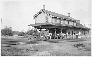
Onset station is a former train station located on Depot Street in the village of East Wareham, Massachusetts. Originally known as Agawam, then East Wareham, it was combined with a nearby station under the name Onset Junction in 1891. Known as Onset by the 1930s, it was closed in 1959. The station building remains in use by a business.

<span class="mw-page-title-main">Tremont station (Massachusetts)</span>

Tremont station was located on Mill Street in West Wareham, Massachusetts. The station was located just east of the former junction of the Cape Cod Branch Railroad and the Fairhaven Branch Railroad.

References

  1. 1 2 3 Gonet, Sarah (December 26, 2012). "Mattapoisett Man of the Year: Bike Path crusader in it for the long haul". South Coast Today.
  2. Sparling, Georgia (April 14, 2014). "Many support rail trail with Bike Night". Sippican Week.
  3. Rails-to-Trails Conservancy (2007). Rail-Trails New England. Wilderness Press. pp. 131–132. ISBN   9780899977072 via Google Books.
  4. DeCicco, Michael J. (December 26, 2018). "Mattapoisett Woman of the Year: For Bonne DeSousa, better biking is a mission". South Coast Today.
  5. "MassDOT moves forward on Mattapoisett bike path". South Coast Today. August 24, 2018.
  6. Monahan, Daniel (January 13, 2019). "Mattapoisett bike path extension to move forward this spring". Sippican Week.
  7. "MassDOT Awards Contract for a New Shared-Use Path Connection in Mattapoisett" (Press release). Massachusetts Department of Transportation. February 14, 2019.
  8. "New Shared-Use Path Connection in Mattapoisett Advances" (Press release). Massachusetts Department of Transportation. March 27, 2019.
  9. 1 2 "January 2019 Mattapoisett-Marion Bike Path update" (PDF). Friends of the Mattapoisett Bike Path. January 2019.
  10. "2020 MassTrails Grant Awards". Commonwealth of Massachusetts. July 2020. p. 1.
  11. Seeberger, Tim (November 23, 2020). "Mattapoisett details plan for Industrial Drive bike path section". Sippican Week.
  12. "2022 MassTrails Awards (81 Projects)". Commonwealth of Massachusetts. June 2022. p. 6.
  13. Whitehead Brothers Company