Fairview-Ferndale, Pennsylvania

Last updated
Fairview-Ferndale
CDP
Street in Fairview-Ferndale, Pennsylvania.JPG
Street in Fairview-Ferndale
USA Pennsylvania location map.svg
Red pog.svg
Fairview-Ferndale
Location within the U.S. state of Pennsylvania
Coordinates: 40°46′59″N76°34′22″W / 40.78306°N 76.57278°W / 40.78306; -76.57278 Coordinates: 40°46′59″N76°34′22″W / 40.78306°N 76.57278°W / 40.78306; -76.57278
Country United States
State Pennsylvania
County Northumberland
Area
[1]
  Total0.97 sq mi (2.52 km2)
  Land0.97 sq mi (2.52 km2)
  Water0.00 sq mi (0.01 km2)
Population
 (2020) [2]
  Total2,075
  Density2,136.97/sq mi (824.70/km2)
Time zone UTC-5 (Eastern (EST))
  Summer (DST) UTC-4 (EDT)
FIPS code 42-24948

Fairview-Ferndale is a census-designated place (CDP), located in Coal Township, in Northumberland County, Pennsylvania, United States. The population was 2,411 at the 2000 census.

Contents

Geography

Fairview-Ferndale is located at 40°46′59″N76°34′22″W / 40.78306°N 76.57278°W / 40.78306; -76.57278 (40.783112, -76.572758). [3]

According to the United States Census Bureau, the CDP has a total area of 0.9 square miles (2.3 km2), all of it land.

Demographics

Historical population
CensusPop.
2020 2,075
U.S. Decennial Census [4]

As of the census [5] of 2000, there were 2,411 people, 1,040 households, and 674 families residing in the CDP. The population density was 2,662.8 people per square mile (1,023.0/km2). There were 1,168 housing units at an average density of 1,290.0/sq mi (495.6/km2). The racial makeup of the CDP was 99.25% White, 0.21% African American, 0.04% Native American, 0.08% Asian, 0.12% from other races, and 0.29% from two or more races. Hispanic or Latino of any race were 0.12% of the population.

There were 1,040 households, out of which 22.7% had children under the age of 18 living with them, 48.3% were married couples living together, 11.3% had a female householder with no husband present, and 35.1% were non-families. 31.6% of all households were made up of individuals, and 17.4% had someone living alone who was 65 years of age or older. The average household size was 2.29 and the average family size was 2.83.

In the CDP, the population was spread out, with 18.8% under the age of 18, 7.5% from 18 to 24, 26.5% from 25 to 44, 24.1% from 45 to 64, and 23.2% who were 65 years of age or older. The median age was 43 years. For every 100 females, there were 90.4 males. For every 100 females age 18 and over, there were 89.5 males.

The median income for a household in the CDP was $27,219, and the median income for a family was $34,976. Males had a median income of $27,850 versus $18,924 for females. The per capita income for the CDP was $15,400. About 10.3% of families and 12.8% of the population were below the poverty line, including 17.8% of those under age 18 and 11.0% of those age 65 or over.

Related Research Articles

<span class="mw-page-title-main">Fairview, California</span> CDP in California, United States

Fairview is a census-designated place (CDP) in Alameda County, California, United States. It borders on the city of Hayward and the census-designated place of Castro Valley. The population was 11,341 at the 2020 census.

<span class="mw-page-title-main">Town 'n' Country, Florida</span> Census-designated place in Florida, United States

Town 'n' Country is a census-designated place (CDP) in Hillsborough County, Florida, United States. The population was 85,951 at the 2020 census.

<span class="mw-page-title-main">Fairview, Georgia</span> CDP in Georgia, United States

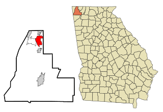
Fairview is a census-designated place (CDP) in Walker County, Georgia, United States. In the 2020 census, the population was 6,409. It is part of the Chattanooga, TN–GA Metropolitan Statistical Area.

<span class="mw-page-title-main">Ferndale, Maryland</span> Census-designated place in Maryland, United States

Ferndale is a census-designated place (CDP) in Anne Arundel County, Maryland, United States. At the 2010 census, the population was 16,746.

<span class="mw-page-title-main">Fairview, Monmouth County, New Jersey</span> Census-designated place in New Jersey, United States

Fairview is an unincorporated community and census-designated place (CDP) located within Middletown Township, in Monmouth County, New Jersey, United States. As of the 2010 United States Census, the CDP's population was 3,806.

<span class="mw-page-title-main">Galeville, New York</span> Census-designated place in New York, United States

Galeville is a hamlet in Onondaga County, New York, United States. The population was 4,617 at the 2010 census.

<span class="mw-page-title-main">Fairview, Westchester County, New York</span> CDP in New York, United States

Fairview is a hamlet and a census-designated place (CDP) located in the town of Greenburgh, Westchester County, New York, United States. The population was 3,099 at the 2010 census. As of 2000, Fairview had the fourth-highest percentage of African-Americans in New York.

<span class="mw-page-title-main">Fairview, Buncombe County, North Carolina</span> Census-designated place in North Carolina, United States

Fairview is a census-designated place (CDP) in Buncombe County, North Carolina, United States. The population was 2,678 at the 2010 census. It is part of the Asheville Metropolitan Statistical Area.

West Wyomissing is a census-designated place (CDP) in Spring Township, Berks County, Pennsylvania, United States. The population was 3,407 at the 2010 census.

Whitfield is a census-designated place (CDP) in Berks County, Pennsylvania, United States. The population was 4,733 at the 2010 census.

<span class="mw-page-title-main">Elim, Pennsylvania</span> Census-designated place in Pennsylvania, United States

Elim is an unincorporated community and census-designated place (CDP) in Upper Yoder Township, Cambria County, Pennsylvania, United States. The population was 3,727 at the 2010 census, down from 4,175 at the 2000 census.

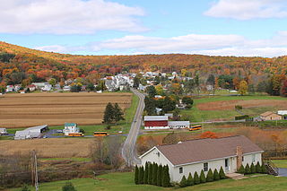
Locustdale is a census-designated place (CDP) in Columbia and Schuylkill counties, Pennsylvania, United States. The population was 177 at the 2010 census. It is part of the Bloomsburg–Berwick Micropolitan Statistical Area.

Lower Allen is a census-designated place (CDP) in Lower Allen Township, Cumberland County, Pennsylvania, United States. The population was 6,694 at the 2010 census. It is part of the Harrisburg–Carlisle Metropolitan Statistical Area.

Branchdale is a census-designated place (CDP) in Schuylkill County, Pennsylvania, United States. The population was 436 at the 2000 census.

<span class="mw-page-title-main">Donaldson, Pennsylvania</span> CDP in Pennsylvania, United States

Donaldson is a census-designated place (CDP) in Frailey Township, Schuylkill County, Pennsylvania, United States. The population was 325 at the 2000 census.

Fountain Springs is a census-designated place in Butler Township, Schuylkill County, Pennsylvania, United States. The population was 100 at the 2000 census.

<span class="mw-page-title-main">Nuremberg, Pennsylvania</span> Census-designated place in Pennsylvania, United States

Nuremberg is a census-designated place (CDP) in Schuylkill and Luzerne counties, Pennsylvania, United States. The population was 434 at the 2010 census.

<span class="mw-page-title-main">Spry, Pennsylvania</span> CDP in Pennsylvania, United States

Spry is a census-designated place (CDP) in York County, Pennsylvania, United States. The population was 4,891 at the 2010 census.

<span class="mw-page-title-main">Minetto (CDP), New York</span> CDP in New York, United States

Minetto is a hamlet in Oswego County, New York, United States. The population was 1,069 at the 2010 census.

East Millinocket is a census-designated place (CDP) consisting of the main settlement in the town of East Millinocket in Penobscot County, Maine, United States. The population was 1,567 at the 2010 census.

References

  1. "ArcGIS REST Services Directory". United States Census Bureau. Retrieved October 12, 2022.
  2. "Census Population API". United States Census Bureau. Retrieved Oct 12, 2022.
  3. "US Gazetteer files: 2010, 2000, and 1990". United States Census Bureau. 2011-02-12. Retrieved 2011-04-23.
  4. "Census of Population and Housing". Census.gov. Retrieved June 4, 2016.
  5. "U.S. Census website". United States Census Bureau . Retrieved 2008-01-31.