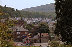
Ranshaw, Pennsylvania | |
|---|---|
 Ranshaw, Pennsylvania | |
 Ranshaw | |
| Coordinates: 40°47′09″N76°31′05″W / 40.78583°N 76.51806°W | |
| Country | United States |
| State | Pennsylvania |
| County | Northumberland |
| Township | Coal |
| Area | |
• Total | 0.14 sq mi (0.36 km2) |
| • Land | 0.14 sq mi (0.36 km2) |
| • Water | 0.00 sq mi (0.00 km2) |
| Elevation | 853 ft (260 m) |
| Population | |
• Total | 176 |
| • Density | 3,297.10/sq mi (1,274.33/km2) |
| Time zone | UTC-5 (Eastern (EST)) |
| • Summer (DST) | UTC-4 (EDT) |
| ZIP code | 17866 |
| Area codes | 570 and 272 |
| FIPS code | 42-63416 |
| GNIS feature ID | 1184656 [3] |
Ranshaw is a village [4] located in Coal Township, Northumberland County in the state of Pennsylvania. The community is located to the east of the city of Shamokin. As of the 2020 census [5] the population was 176 residents.
