Filisur

Last updated • 3 min readFrom Wikipedia, The Free Encyclopedia
Filisur
Filisur Albulatal.jpg
View of Filisur looking southeast, upwards towards the Albula Pass
Flag of Filisur.gif
Filisur-coat of arms.png
Location of Filisur
Filisur
Switzerland adm location map.svg
Red pog.svg
Filisur
Reliefkarte Graubunden blank.png
Red pog.svg
Filisur
Coordinates: 46°40′N9°41′E / 46.667°N 9.683°E / 46.667; 9.683
Country Switzerland
Canton Graubünden
District Albula
Area
[1]
  Total44.58 km2 (17.21 sq mi)
Elevation
1,032 m (3,386 ft)
Population
 (2017-12-31) [2]
  Total434
  Density9.7/km2 (25/sq mi)
Time zone UTC+01:00 (Central European Time)
  Summer (DST) UTC+02:00 (Central European Summer Time)
Postal code(s)
7477
SFOS number 3522
Surrounded by Alvaneu, Bergün/Bravuogn, Savognin, Schmitten, Tiefencastel, Tinizong-Rona, Davos
Website www.filisur.ch
SFSO statistics

Filisur is an Alpine village and former municipality in the Albula Region in the canton of Graubünden in Switzerland. The village sits on a hillside with a view to the west where the two rivers Albula/Alvra from the Albula Pass and Landwasser from Davos meet. On 1 January 2018 the former municipalities of Bergün/Bravuogn and Filisur merged into the new municipality of Bergün Filisur. [3]

Contents

History

Filisur railway station RhB08.jpg
Filisur railway station

Filisur is first mentioned in 1262 as villa Fallisour. [4]

Geography

Aerial view (1947) ETH-BIB-Filisur-LBS H1-010157.tif
Aerial view (1947)

Filisur has an area, as of 2006, of 44.6 km2 (17.2 sq mi). Of this area, 18.1% is used for agricultural purposes, while 46.6% is forested. Of the rest of the land, 1.6% is settled (buildings or roads) and the remainder (33.7%) is non-productive (rivers, glaciers or mountains). [5]

Before 2017, the municipality was located in the Bergün subdistrict of the Albula district, since 2017 it is part of the Albula Region. [6] It consists of the village of Filisur and the hamlet of Jenisberg at an elevation of 1,504 m (4,934 ft).

Demographics

Filisur has a population (as of 31 December 2020) of 434. [7] As of 2008, 14.1% of the population was made up of foreign nationals. Over the last 10 years the population has grown at a rate of 0.8%. Most of the population (as of 2000) speaks German (84.5%), with Italian being second most common (6.7%) and Romansh being third (3.0%). [5]

As of 2000, the gender distribution of the population was 49.5% male and 50.5% female. [8] The age distribution, as of 2000, in Filisur is; 58 people or 12.4% of the population are between 0 and 9 years old. 36 people or 7.7% are 10 to 14, and 23 people or 4.9% are 15 to 19. Of the adult population, 60 people or 12.9% of the population are between 20 and 29 years old. 57 people or 12.2% are 30 to 39, 67 people or 14.4% are 40 to 49, and 72 people or 15.5% are 50 to 59. The senior population distribution is 39 people or 8.4% of the population are between 60 and 69 years old, 31 people or 6.7% are 70 to 79, there are 17 people or 3.6% who are 80 to 89, and there are 6 people or 1.3% who are 90 to 99. [9]

In the 2007 federal election the most popular party was the FDP which received 36.5% of the vote. The next three most popular parties were the SVP (33.3%), the SPS (22%) and the CVP (6.5%). [5]

In Filisur about 69.4% of the population (between age 25-64) have completed either non-mandatory upper secondary education or additional higher education (either university or a Fachhochschule ). [5]

Filisur has an unemployment rate of 2.02%. As of 2005, there were 72 people employed in the primary economic sector and about 10 businesses involved in this sector. 34 people are employed in the secondary sector and there are 8 businesses in this sector. 86 people are employed in the tertiary sector, with 16 businesses in this sector. [5]

The historical population is given in the following table: [4] [8]

yearpopulation
1803164
1850280
1888273
1900644 a
1910333
1950375
1960318
1970325
1980410
1990413
2000333
^a Population increase during construction of the Rhaetian Railway line

Weather

Filisur has an average of 109.9 days of rain per year and on average receives 893 mm (35.2 in) of precipitation. The wettest month is August during which time Filisur receives an average of 122 mm (4.8 in) of precipitation. During this month there is precipitation for an average of 12.3 days. The driest month of the year is February with an average of 43 mm (1.7 in) of precipitation over 12.3 days. [10]

Heritage sites of national significance

Landwasser Viaduct, 65 m (213 ft) high and 136 m (446 ft) long, built in 1902 Mh rhb 706 auf landwasserviadukt.jpeg
Landwasser Viaduct, 65 m (213 ft) high and 136 m (446 ft) long, built in 1902
Ruins of Greifenstein Castle Greifenstein NW.jpg
Ruins of Greifenstein Castle

The castle ruins of Greifenstein and the Schmittentobel-Landwasser Viaduct of the Rhaetian Railway are listed as Swiss heritage sites of national significance. [11]

Transportation

Filisur's railway station is located in the northwest of the village 50 metres above the center and served by the Rhaetian Railway (RhB), the Glacier Express and the Bernina Express on the route between Chur (585 metres (1,919 ft)) and St. Moritz (1,775 metres (5,823 ft)). It is also the end station for the line to Davos.

PostBus Switzerland also operate services through the village.

Related Research Articles

<span class="mw-page-title-main">Vals, Switzerland</span> Municipality in Graubünden, Switzerland

Vals is a village and a municipality in the Surselva Region in the canton of Graubünden in Switzerland. On 1 January 2015 the former municipality of St. Martin merged into the municipality of Vals.

<span class="mw-page-title-main">Albula District</span> District in Switzerland

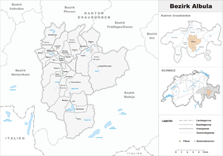
Albula District was one of the eleven administrative districts in the canton of Graubünden in Switzerland. It had an area of 723.13 km² and had a population of 8,210 in 2015. It was replaced with the Albula Region on 1 January 2017 as part of a reorganization of the Canton.

<span class="mw-page-title-main">Bever, Switzerland</span> Municipality in Graubünden, Switzerland

Bever is a municipality in the Maloja Region in the Swiss canton of Graubünden.

<span class="mw-page-title-main">Trun, Switzerland</span> Municipality in Graubünden, Switzerland

Trun is a municipality in the Surselva Region in the canton of Graubünden in Switzerland. The municipality of Schlans merged on 1 January 2012 into the municipality of Trun.

<span class="mw-page-title-main">Avers</span> Municipality in Grisons, Switzerland

Avers is a high Alpine valley region and a municipality in the Viamala Region in the Swiss canton of Graubünden. It includes Juf, the highest-altitude year-round settlement in Europe.

<span class="mw-page-title-main">Bergün/Bravuogn</span> Former municipality in Graubünden, Switzerland

Bergün/Bravuogn is a village and former municipality in the Albula Region in the canton of Graubünden in Switzerland. The double name (German/Romansh) has been the official name since 1943. On 1 January 2018 the former municipalities of Bergün/Bravuogn and Filisur merged into the new municipality of Bergün Filisur.

<span class="mw-page-title-main">Andeer</span> Municipality in Graubünden, Switzerland

Andeer is a municipality in the Viamala Region in the Swiss canton of Graubünden. In 2009 Clugin and Pignia merged into Andeer.

<span class="mw-page-title-main">Andiast</span> Former municipality in Graubünden, Switzerland

Andiast is a former municipality in the Surselva Region in the Swiss canton of Graubünden. Until 1943, it was known as Andest.

<span class="mw-page-title-main">Grüsch</span> Municipality in Graubünden, Switzerland

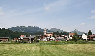
Grüsch is a Swiss village in the Prättigau and a municipality in the political district Prättigau/Davos Region in the canton of Graubünden. On 1 January 2011, the former municipalities of Fanas and Valzeina were merged with Grüsch.

<span class="mw-page-title-main">Küblis</span> Municipality in Graubünden, Switzerland

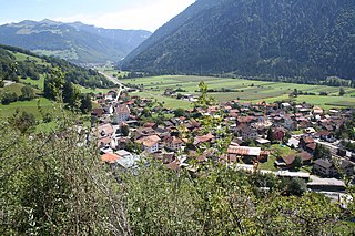
Küblis or Kublis is a Swiss village in the Prättigau and a municipality in the political district Prättigau/Davos Region in the canton of Graubünden.

<span class="mw-page-title-main">Lantsch/Lenz</span> Municipality in Graubünden, Switzerland

Lantsch/Lenz is a municipality in the Albula Region in the canton of Graubünden in Switzerland.

<span class="mw-page-title-main">Schmitten, Graubünden</span> Municipality in Graubünden, Switzerland

Schmitten is a municipality in the Albula Region in the canton of Graubünden in Switzerland.

<span class="mw-page-title-main">Hinterrhein, Switzerland</span> Municipality in Graubünden, Switzerland

Hinterrhein is a village and a former municipality in the Viamala Region in the Swiss canton of Graubünden. The village is located near the start of the river Hinterrhein/Rein Posteriur, one of the two initial tributaries of the Rhine. On 1 January 2019 the former municipalities of Hinterrhein, Nufenen and Splügen merged to form the new municipality of Rheinwald.

<span class="mw-page-title-main">Tiefencastel</span> Former municipality in Graubünden, Switzerland

Tiefencastel is a village and a former municipality in the district of Albula in the canton of Graubünden in Switzerland. On 1 January 2015 the former municipalities of Alvaschein, Mon, Stierva, Tiefencastel, Alvaneu, Brienz/Brinzauls and Surava merged to form the new municipality of Albula/Alvra.

<span class="mw-page-title-main">Thusis</span> Municipality in Graubünden, Switzerland

Thusis is a municipality in the Viamala Region in the Swiss canton of Graubünden. On 1 January 2018 the former municipality of Mutten merged into the municipality of Thusis.

<span class="mw-page-title-main">Rothenbrunnen</span> Municipality in Graubünden, Switzerland

Rothenbrunnen is a municipality in the Viamala Region in the Swiss canton of Graubünden.

<span class="mw-page-title-main">Sagogn</span> Municipality in Graubünden, Switzerland

Sagogn is a municipality in the Surselva Region in the canton of Graubünden in Switzerland.

<span class="mw-page-title-main">Albula/Alvra</span> Municipality in Graubünden, Switzerland

Albula/Alvra is a municipality in the Albula Region in the canton of Graubünden in Switzerland. On 1 January 2015, the former municipalities of Alvaschein, Mon, Stierva, Tiefencastel, Alvaneu, Brienz/Brinzauls, and Surava merged to form the new municipality of Albula/Alvra.

Albula Region is one of the eleven administrative districts in the canton of Graubünden in Switzerland. It has an area of 683.51 square kilometers (263.90 sq mi) and a population of 8,175 .. It was created on 1 January 2017 as part of a reorganization of the Canton.

<span class="mw-page-title-main">Bergün Filisur</span> Municipality in Graubünden, Switzerland

Bergün Filisur is a municipality in the Albula Region in the canton of Graubünden in Switzerland. On 1 January 2018 the former municipalities of Bergün/Bravuogn and Filisur merged to form the new municipality of Bergün Filisur.

References

  1. "Arealstatistik Standard - Gemeinden nach 4 Hauptbereichen". Federal Statistical Office. Retrieved 13 January 2019.
  2. "Bilanz der ständigen Wohnbevölkerung nach institutionellen Gliederungen, Staatsangehörigkeit (Kategorie), Geschlecht und demographischen Komponenten". Federal Statistical Office. Retrieved 12 January 2019.
  3. Amtliches Gemeindeverzeichnis der Schweiz published by the Swiss Federal Statistical Office (in German) accessed 14 February 2018
  4. 1 2 Filisur in German , French and Italian in the online Historical Dictionary of Switzerland .
  5. 1 2 3 4 5 Swiss Federal Statistical Office Archived January 5, 2016, at the Wayback Machine accessed 24-Sep-2009
  6. Swiss Federal Statistical Office - Amtliches Gemeindeverzeichnis der Schweiz - Mutationsmeldungen 2016 accessed 16 February 2017
  7. "Ständige und nichtständige Wohnbevölkerung nach institutionellen Gliederungen, Geburtsort und Staatsangehörigkeit". bfs.admin.ch (in German). Swiss Federal Statistical Office - STAT-TAB. 31 December 2020. Retrieved 21 September 2021.
  8. 1 2 Graubunden in Numbers Archived September 24, 2009, at the Wayback Machine (in German) accessed 21 September 2009
  9. Graubunden Population Statistics Archived August 27, 2009, at the Wayback Machine (in German) accessed 21 September 2009
  10. "Temperature and Precipitation Average Values-Table, 1961-1990" (in German, French, and Italian). Federal Office of Meteorology and Climatology - MeteoSwiss. Archived from the original on 27 June 2009. Retrieved 8 May 2009., the weather station elevation is 1030 meters above sea level.
  11. Swiss inventory of cultural property of national and regional significance Archived May 1, 2009, at the Wayback Machine 21.11.2008 version, (in German) accessed 24-Sep-2009