
This is a list of the National Register of Historic Places listings in Lancaster County, Pennsylvania.
Fort Frederick Heritage Preserve is a 3-acre (12,000 m2) property located in Port Royal, South Carolina. Situated along the Beaufort River, the preserve contains the remains of Fort Frederick. Also known as Fort Prince Frederick, the tabby fort was built by the British between 1730 and 1734 to defend against a possible attack from the Spanish at St. Augustine, Florida. It was named to the National Register of Historic Places in 1974.
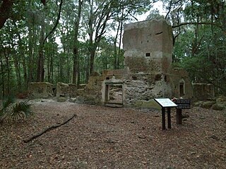
Stoney-Baynard Plantation on Hilton Head Island, SC was listed on the National Register of Historic Places in 1994. The listing included one contributing site on 6 acres (2.4 ha).
Altamaha Town is an archaeological site in the Bluffton, South Carolina area. It was the location of Altamaha, the head town of the Lower Towns of the Yamasee tribe during their entire 30 year presence in South Carolina. Evidence dates the beginning of this period from 1707–1715, though it is possible the town was formed as early as 1695. The area encompassed over 100 acres (40 ha) and 40 houses. There is also archaeological evidence to suggest that the site was also occupied intermittently prior to the arrival of the Yamasee, from at least 1500 BC to 1715 AD.
Chester Field, located in Beaufort County, South Carolina, is one of the nearly two dozen prehistoric shell rings that run from the center coast of South Carolina to the central coast of Georgia. Archaeologists date the pottery that has been found at these sites to be in the second millennium BC, this placing the artifacts among the earliest pottery of North America. The purpose or use of the ring shape is not known. This “address restricted” site was listed in the National Register of Historic Places on October 15, 1970.
The Fort Lyttelton Site, located in Beaufort County, South Carolina, is significant for its rich and layered artifacts and structural remains., These provide a composite view of land use since colonial times. In the 18th century and early into the 19th century, the land was primarily used for military purposes. In the late 19th century, the "phosphate period" followed the military period. Shipbuilding became important in the early 20th century. The Fort Lyttelton Site was listed in the National Register of Historic Places on September 13, 1979.
Archaeological ruins suggest that Indian Hill Site, an "address restricted landmark" in Beaufort County, in the U.S. state of South Carolina, was inhabited between 900 and 1400 AD. The mound that dominates the area is over 13 ft (4.0 m) tall, with a basal diameter of 138 ft (42 m) (east-west), and 129 ft (39 m) (north-south). It is believed that the Indian Hill site served as a regional ceremonial center for religious, social and economic functions. The site was listed in the National Register of Historic Places on March 24, 1974.
Hasell Point, an “address restricted” landmark in Beaufort County, South Carolina, with its mix of burial mounds, potter and an oyster shell midden, is a potentially important archaeological site, one that may yield significant information dating to 500 AD. Hasell Point was listed in the National Register of Historic Places on August 14, 1973.
Lands End Road Tabby Ruins is a historic archeological site located on Saint Helena Island near Frogmore, Beaufort County, South Carolina. The site contains the archaeological remains of a large late-18th to early-19th century house. The site has a tabby foundation pier and the partial outlines of a structure.
St. Helenaville Archaeological Site is a historic archeological site located on Saint Helena Island near Frogmore, Beaufort County, South Carolina. St. Helenaville was a small antebellum village and summer retreat located on the northeastern end of St. Helena Island. St. Helenaville was damaged by several major storms, which ultimately caused part of the village to fall into the sound. There is very little historical documentation of the village. Several remains of tabby and brick are evident.
Sea Pines is a historic archeological site located at Sea Pines Resort, Hilton Head Island, Beaufort County, South Carolina. The site is one of 20 or more prehistoric Indian shell middens in a ring shape located from the central coast of South Carolina to the central coast of Georgia. It is believed to date early in the second millennium BC, and to contain some of the earliest pottery known in North America. The Sea Pines ring stands about two feet above a flat central area, which is about five feet above mean sea level.
Green's Shell Enclosure is a historic archeological site located at Hilton Head Island, Beaufort County, South Carolina. The site includes one of 20 or more prehistoric Indian shell middens in a ring shape located from the central coast of South Carolina to the central coast of Georgia. They are believed to date early in the second millennium BC, and they contain some of the earliest pottery known in North America.
Pocosobo Town, also known as The Rule Site, is a historic archaeological site located near Sheldon, Beaufort County, South Carolina. The site was occupied by the Yamasee, an indigenous group that played a crucial role in the early colonial history of South Carolina. This site may have been occupied by the Yemasee as early as 1695, but it was definitely the location of Pocosabo Town from 1707 to 1715.
Laurel Bay Plantation, also known as Woodward Plantation and Tabby Ruin Site, is a historic archaeological site located near Beaufort, Beaufort County, South Carolina. The site contains artifacts associated with domestic outbuilding activities related to either or both Laurel Bay Plantation and Woodward Plantation. Features present at the site include sections of two tabby walls, a tabby structure foundation, two depressions, two brick piles, and a shell pile.
SS William Lawrence Shipwreck Site is a historic shipwreck and archaeological site located near Hilton Head Island, Beaufort County, South Carolina. The SS William Lawrence (1869) was built by the Atlantic Ironworks in Boston in 1869. She was ordered by the Merchants and Miners Transportation Company, whose passenger and cargo steamers had been running up and down the East Coast since 1852. The ship wrecked during an ice storm in February 1899. Some cargo was recovered from the wreck in 1990 and included: leather shoes; fabric; glassware and containers filled with medicine, pickles and preserves; toys; dolls; ornaments; artwork; and comic books.
Prehistoric Indian Village, also known as Arant's Field, is a historic archaeological site located near St. Matthews, Calhoun County, South Carolina. This site was occupied in the Archaic Period, probably by small groups of hunter-gatherers. During the first millennium AD, a large agricultural community was situated in the area, with a tentative date of occupation of ca. 500 AD.
Archeological Site 38CK1, also known as the Upton Site, is a historic archaeological site located near Gaffney, Cherokee County, South Carolina. The site contains well preserved examples of a specialized soapstone procurement site occupied primarily during the prehistoric, Late Archaic Period. The site is divided into two major areas and the quarry exhibits both historic and prehistoric utilization.
Archeological Site 38CK44, also known as Locus 1, is a historic archaeological site located near Gaffney, Cherokee County, South Carolina. The site contains well preserved examples of a specialized soapstone procurement site occupied primarily during the prehistoric, Late Archaic Period.
Archeological Site 38CK45, also known as Locus 2, is a historic archaeological site located near Gaffney, Cherokee County, South Carolina. The site contains well preserved examples of a specialized soapstone procurement site occupied primarily during the prehistoric, Late Archaic Period.
The Adamson Mounds Site (38KE11) is an archaeological site located near Camden, Kershaw County, South Carolina. It is a prehistoric Native American village site containing one large platform mound, a smaller mound, possibly a third still smaller mound, and a burial area. It served as a regional ceremonial center. This site represents a widespread, late prehistoric Mississippian culture known by the names of Lamar, Irene, or Pee Dee and dates probably between AD 1400 and AD 1700.

