Fishing in Ohio

Last updated

Ohio currently has 5 rivers that host populations of either rainbow trout, brown trout, or brook trout. These rivers are the Mad River, the Clear Fork River, Clear Creek, the Chagrin River, and the Rocky River.

Contents

The Mad River

Ohio's oldest trout stream is the Mad River. Stocking of this river began in the late 19th century with the introduction of Brook trout. In 1884 Rainbow trout were introduced to the stream. In 1931 the Ohio Department of Natural Resources (ODNR) Division of Wildlife took control of the Rainbow trout project. The department continued to support the project until 1984 when the state introduced Brown trout in their stead. Today the stream is stocked annually with 6"-8" brown trout to supplement the population.

Public access points can be found at various locations along the river which begins in Logan County near the city of Bellefontaine and runs southwest to Dayton where it flows into the Great Miami River. These access points are generally small and tend to be next to bridges where local roads cross the river.

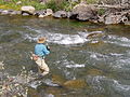
As there are hatches of mayflies, caddis flies, and other popular trout foods throughout the spring, summer, and fall months, fly fishing on the river is viable. Other popular methods of fishing include the use of in-line spinners such as Rooster Tails or Mepps, or the use of live bait rigs or Berkley Power Bait.

The minimum size required to keep trout caught on the Mad River is 12 inches, and the daily catch limit is two fish.

The Clear Fork River

The Clear Fork River is located near the town of Loudonville, OH, about one hour north of the city of Columbus, OH. It is divided into two parts, the Upper and the Lower branches. It was first stocked in the early 1980s by local fishing clubs, and the ODNR began in 1992 to stock it annually with 6"-8" brown trout. Two of its tributaries, Cedar Fork on the Upper branch and Pine Run on the Lower branch, are also stocked. The Upper branch has limited accessibility and runs from the Clear Fork Reservoir East to Pleasant Hill Lake. The Lower Branch runs East from the Pleasant Hill Dam through Mohican State Park where it ends at the Mohican River.

Fishermen who wish to visit this stream should go to the covered bridge at Mohican State Park. There is plenty of parking, a playground for the kids, a primitive campground just downstream, and easy access to the stream. Fly fishing is excellent as there are many open areas to cast and several nice holes with hemlock trees holding their branches over them waiting for the fisherman to drift a dry fly or a nymph under them. The stream has a great annual hatch of mayflies, including sulphers[ check spelling ], light cahills, drakes, and many caddisflies, as well. Other popular methods include the use of in-line spinners and live bait.

This is a very scenic river with great accessibility. The downfall is that in the late spring and summer months many other visitors are attracted to the stream such as rafters, tubers, and swimmers, which can negatively affect fishing as the water becomes too disturbed. Other than that, this is a great place to fish for trout in Ohio. The daily catch limit is two fish and a minimum keep size of 12" is in effect. note=most of the swimmers, tubers, and rafters use the state park camping area for this activity, the best trout fishing for large browns is upstream from the covered bridge.

Clear Creek

Located just southeast of Lancaster in Clear Creek Metro Park lies Clear Creek, one of the newest streams in Ohio to receive the title of trout stream. Overseen by the ODNR, the river is stocked annually with 6"-8" Brown trout. It is the only trout stream in the Southeastern portion of Ohio.

The fishable area runs throughout the entirety of Clear Creek Metro Park and access points can be found along the road that runs through the park.

This trout stream has a minimum keep size of 12" for trout and a daily catch limit of two trout.

The Chagrin River and the Rocky River

A tributary in Geauga County of the Chagrin River, and the Rocky River and its tributaries, located in Medina County, are the host to populations of wild Brook trout in Ohio. The Chagrin tributary is the only remaining naturally occurring population of native Brook Trout in Ohio. Both of these rivers are located in Northeast Ohio. State regulations prohibit possession of trout from these waters. For this reason it is advisable to use barbless hooks when fishing for trout in either of these two rivers but it is legal to harvest steelhead trout from these two rivers.

See also

Related Research Articles

<span class="mw-page-title-main">Trout</span> Number of species of freshwater fish

Trout are species of freshwater fish belonging to the genera Oncorhynchus, Salmo and Salvelinus, all of the subfamily Salmoninae of the family Salmonidae. The word trout is also used as part of the name of some non-salmonid fish such as Cynoscion nebulosus, the spotted seatrout or speckled trout.

<span class="mw-page-title-main">Lamar River</span> River in Wyoming, United States

The Lamar River is a tributary of the Yellowstone River, approximately 40 miles (64 km) long, in northwestern Wyoming in the United States. The river is located entirely within Yellowstone National Park.

<span class="mw-page-title-main">West Branch Delaware River</span> River in New York, United States

The West Branch Delaware River is one of two branches that form the Delaware River. It is approximately 90 mi (144 km) long, and flows through the U.S. states of New York and Pennsylvania. It winds through a mountainous area of New York in the western Catskill Mountains for most of its course, before joining the East Branch along the northeast border of Pennsylvania with New York. Midway or so it is empounded by the Cannonsville Dam to form the Cannonsville Reservoir, both part of the New York City water supply system for delivering drinking water to the City.

<span class="mw-page-title-main">Neversink River</span> River in New York, United States

The Neversink River is a 55-mile-long (89 km) tributary of the Delaware River in southeastern New York in the United States. The name of the river comes from the corruption of an Algonquian language phrase meaning "mad river."

<span class="mw-page-title-main">Brook trout</span> Species of fish

The brook trout is a species of freshwater fish in the char genus Salvelinus of the salmon family Salmonidae. It is native to Eastern North America in the United States and Canada, but has been introduced elsewhere in North America, as well as to Iceland, Europe, and Asia. In parts of its range, it is also known as the eastern brook trout, speckled trout, brook charr, squaretail, brookie or mud trout, among others. A potamodromous population in Lake Superior, as well as an anadromous population in Maine, is known as coaster trout or, simply, as coasters. The brook trout is the state fish of nine U.S. states: Michigan, New Hampshire, New Jersey, New York, North Carolina, Pennsylvania, Vermont, Virginia, and West Virginia, and the Provincial Fish of Nova Scotia in Canada.

<span class="mw-page-title-main">Golden trout</span> Species of fish

The Californiagolden trout (Oncorhynchus aguabonita or Oncorhynchus mykiss aguabonita), is a species of trout native to California. The golden trout is normally found in the Golden Trout Creek, Volcano Creek, and the South Fork Kern River. The Golden trout is the official freshwater state fish of California since 1947.

<span class="mw-page-title-main">Salmon River (New York)</span> River in New York, United States

The Salmon River is a small river north of Syracuse in Upstate New York, the United States. It is a popular and economically important sportfishing destination, and the most heavily fished of New York's Lake Ontario tributaries. From its headwaters in the Tug Hill region of New York, it flows 44 miles (71 km) westward through two hydroelectric dams and over the 110-foot (34 m) Salmon River Falls before it empties into eastern Lake Ontario at Port Ontario in Oswego County. The Salmon River watershed drains approximately 280 square miles (730 km2).

<span class="mw-page-title-main">Bitterroot River</span> River in Montana, United States

The Bitterroot River is a northward flowing 84-mile (135 km) river running through the Bitterroot Valley, from the confluence of its West and East forks near Conner in southern Ravalli County to its confluence with the Clark Fork River near Missoula in Missoula County, in western Montana. The Clark Fork River is tributary to the Columbia River and ultimately, the Pacific Ocean. The Bitterroot River is a Blue Ribbon trout fishery with a healthy population of native westslope cutthroat trout and bull trout. It is the third most fly fished river in Montana behind the Madison and Big Horn Rivers.

<span class="mw-page-title-main">Bowman Creek</span> River

Bowman Creek is a tributary of the Susquehanna River in Luzerne County and Wyoming County, in Pennsylvania, in the United States. It is approximately 26 miles (42 km) long and flows through Ross Township and Lake Township in Luzerne County and Noxen Township, Monroe Township, and Eaton Township in Wyoming County. The watershed of the creek has an area of 120 square miles (310 km2). The creek is not designated as an impaired waterbody and its pH is close to neutral, although it has experienced some problems with acid rain. It has low concentrations of dissolved solids like calcium. The creek is relatively small in its upper reaches, but by Noxen, its width is 40 to 60 feet. It is also relatively shallow in many reaches. Rock formations in the watershed include the Catskill Formation, the Huntley Mountain Formation, Burgoon Sandstone, the Mauch Chunk Formation, the Pottsville Group, and the Pocono Formation. Soil associations in the creek's watershed include the Wellsboro-Morris-Oquaga association, the Oquaga-Lackawanna-Arnot association, the Mardin-Bath-Volusia association, and the Wyoming-Pope association.

<span class="mw-page-title-main">Gibbon River</span> River in Wyoming, United States

The Gibbon River flows east of the Continental Divide in Yellowstone National Park, in northwestern Wyoming, the Northwestern United States. Along with the Firehole River, it is a major tributary of the Madison River, which itself is a tributary of the Missouri River.

<span class="mw-page-title-main">Angling in Yellowstone National Park</span>

Angling in Yellowstone National Park is a major reason many visitors come to the park each year and since it was created in 1872, the park has drawn anglers from around the world to fish its waters. In 2006, over 50,000 park fishing permits were issued to visitors. The park contains hundreds of miles of accessible, high-quality trout rivers containing wild trout populations—over 200 creeks, streams and rivers are fishable. There are 45 fishable lakes and several large lakes are easily accessible to visitors. Additionally, the park's remote sections provide anglers ample opportunity to visit rivers, streams, creeks and lakes that receive little angling pressure. With the exception of one specially designated drainage, all the park's waters are restricted to artificial lures and fly fishing. The Madison, Firehole and a section of the Gibbon rivers are restricted to fly fishing only.

Smith Creek is a 35.5-mile-long (57.1 km) tributary stream of the North Fork of the Shenandoah River in the Shenandoah Valley of Virginia. Its watershed comprises 106 square miles (270 km2) within Shenandoah and Rockingham counties on the western slope of the Massanutten Mountain ridge. Its headwaters lie in Rockingham County just north of Harrisonburg, and its confluence with the North Fork of the Shenandoah River is located just south of Mount Jackson.

<span class="mw-page-title-main">Willowemoc Creek</span> River in New York, United States

Willowemoc Creek is a tributary of Beaver Kill. It is a popular trout fishing stream near the Catskill Park in Sullivan County, New York.

Fish Creek is a moderately sized river emptying into the eastern end of Oneida Lake in Oneida County, New York. Formed by the confluence of its east and west forks near the hamlet of Blossvale, the creek flows southwest for 11 miles (18 km), through the towns of Annsville and Vienna. The last mile of the creek is channelized to form part of the Erie Canal, which joins the lake at Sylvan Beach. The creek drains approximately 528.9 square miles (1,370 km2) of the Tug Hill plateau country in Central New York.

<span class="mw-page-title-main">Class A Wild Trout Waters</span> Class given to streams in Pennsylvania by the Pennsylvania Fish and Boat Commission.

Class A Wild Trout Waters are the highest biomass class given to streams in Pennsylvania by the Pennsylvania Fish and Boat Commission. They are considered to contain the highest-quality naturally reproducing trout populations in Pennsylvania. The first streams received their Class A Wild Trout Waters designations in 1983. There are now hundreds of such waters, comprising nearly 1,500 miles (2,400 km) of streams. Class A Wild Trout Waters receive certain legal protections. For instance, they are typically classified by the Pennsylvania Department of Environmental Protection as High-Quality Coldwater Fisheries. Most Class A Wild Trout Waters are subject to standard statewide angling regulations by the Pennsylvania Fish and Boat Commission.

References