
Yellowstone Lake is the largest body of water in Yellowstone National Park. The lake is 7,732 feet (2,357 m) above sea level and covers 136 square miles (350 km2) with 110 miles (180 km) of shoreline. While the average depth of the lake is 139 ft (42 m), its greatest depth is at least 394 ft (120 m). Yellowstone Lake is the largest freshwater lake above 7,000 ft (2,100 m) in North America.

The Yellowstone River is a tributary of the Missouri River, approximately 692 miles (1,114 km) long, in the Western United States. Considered the principal tributary of upper Missouri, via its own tributaries it drains an area with headwaters across the mountains and high plains of southern Montana and northern Wyoming, and stretching east from the Rocky Mountains in the vicinity of Yellowstone National Park. It flows northeast to its confluence with the Missouri River on the North Dakota side of the border, about 25 miles (40 km) west of Williston.

The Madison River is a headwater tributary of the Missouri River, approximately 183 miles (295 km) long, in Wyoming and Montana. Its confluence with the Jefferson and Gallatin rivers near Three Forks, Montana forms the Missouri River.

The Lamar River is a tributary of the Yellowstone River, approximately 40 miles (64 km) long, in northwestern Wyoming in the United States. The river is located entirely within Yellowstone National Park.
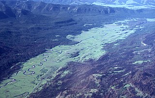
Slough Creek is a tributary of the Lamar River, approximately 25 mi (40 km) long, in Montana and Wyoming in the United States.

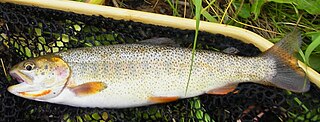
The cutthroat trout(Oncorhynchus clarkii) is a fish species of the family Salmonidae native to cold-water tributaries of the Pacific Ocean, Rocky Mountains, and Great Basin in North America. As a member of the genus Oncorhynchus, it is one of the Pacific trout, a group that includes the widely distributed rainbow trout. Cutthroat trout are popular gamefish, especially among anglers who enjoy fly fishing. The common name "cutthroat" refers to the distinctive red coloration on the underside of the lower jaw. The specific name clarkii was given to honor explorer William Clark, coleader of the Lewis and Clark Expedition.

Caribou–Targhee National Forest is located in the states of Idaho and Wyoming, with a small section in Utah in the United States. The forest is broken into several separate sections and extends over 2.63 million acres (10,600 km2). To the east the forest borders Yellowstone National Park, Grand Teton National Park and Bridger–Teton National Forest. Most of the forest is a part of the 20-million-acre (81,000 km2) Greater Yellowstone Ecosystem.

The Firehole River is located in northwestern Wyoming, and is one of the two major tributaries of the Madison River. It flows north approximately 21 miles (34 km) from its source in Madison Lake on the Continental Divide to join the Gibbon River at Madison Junction in Yellowstone National Park. It is part of the Missouri River system.
The Snake River fine-spotted cutthroat trout is a form of the cutthroat trout that is considered either as a separate subspecies O. c. behnkei, or as a variety of the Yellowstone cutthroat trout. The fish takes its common name from its original habitat, the Snake River of southern Idaho and western Wyoming, and from its unusual pattern of hundreds of small spots that cover most of its body, differing from the larger-spotted Yellowstone cutthroat pattern. Genetically, it cannot be distinguished from the Yellowstone cutthroat trout, and before the construction of dams, no physical barriers were between the ranges of the two subspecies in the Snake River drainage.

The Gibbon River flows east of the Continental Divide in Yellowstone National Park, in northwestern Wyoming, the Northwestern United States. Along with the Firehole River, it is a major tributary of the Madison River, which itself is a tributary of the Missouri River.

Angling in Yellowstone National Park is a major reason many visitors come to the park each year and since it was created in 1872, the park has drawn anglers from around the world to fish its waters. In 2006, over 50,000 park fishing permits were issued to visitors. The park contains hundreds of miles of accessible, high-quality trout rivers containing wild trout populations—over 200 creeks, streams and rivers are fishable. There are 45 fishable lakes and several large lakes are easily accessible to visitors. Additionally, the park's remote sections provide anglers ample opportunity to visit rivers, streams, creeks and lakes that receive little angling pressure. With the exception of one specially designated drainage, all the park's waters are restricted to artificial lures and fly fishing. The Madison, Firehole and a section of the Gibbon rivers are restricted to fly fishing only.

The Gardner River is a tributary of the Yellowstone River, approximately 25 miles (40 km) long, in northwestern Wyoming and south central Montana in the United States. The entire river is located within Yellowstone National Park. It rises on the slope of Joseph Peak, Gallatin Range in the northwestern part of the park, and winds southeast through Gardner's Hole, a broad subalpine basin which is a popular trout fishing location. The Gardner falls within the Native Trout Conservation Area and anglers are allowed to take an unlimited number of brown and rainbow trout. Mountain whitefish and Yellowstone cutthroat trout must be released. Angling on the Gardner is governed by Yellowstone National Park fishing regulations. After merging with Panther Creek, Indian Creek and Obsidian Creek, it then turns north and flows through a steep canyon where it cuts through a basaltic flow from approximately 500,000 years ago known as Sheepeater Cliffs. Below Sheepeater, Glen Creek out of Golden Gate Canyon and Lava Creek out of Lava Creek Canyon join the Gardner near Mammoth Hot Springs. The river crosses the 45th parallel in Gardner Canyon and is also home to a popular hot spring known as The Boiling River. The river continues north through Gardner Canyon and empties into the Yellowstone near Gardiner, Montana.

Dan Bailey was a fly-shop owner, innovative fly developer and staunch Western conservationist. Born on a farm near Russellville, Kentucky, Bailey is best known for the fly shop he established in Livingston, Montana in 1938. Dan Bailey's Fly Shop is still in business.

Trout Lake, formerly known as Fish Lake and Soda Butte Lake, is a 12 acres (0.049 km2) popular backcountry lake for hikers and anglers in Yellowstone National Park. The lake is located approximately .33 miles (0.53 km) north of the Northeast Entrance Road near the confluence of Pebble Creek and Soda Butte Creek. The lake sits in a depression on a high bench above the Soda Butte Creek Canyon. A steep trail through a Douglas fir forest leads to the lake. The trailhead is located at: 44°53′57″N110°7′21″W.

Shoshone Lake is a U.S. backcountry lake with an area of 8,050 acres with an elevation of 7,795 feet (2,376 m) in the southwest section of Yellowstone National Park, Wyoming. It lies at the headwaters of the Lewis River, a tributary of the Snake River. The U.S. Fish and Wildlife Service believes that Shoshone Lake is the largest backcountry lake in the lower 48 states that cannot be reached by a road. The Yellowstone Caldera is located within the lake.

Heart Lake el. 7,461 feet (2,274 m) is a large backcountry lake, nestled at the base of Mount Sheridan in Yellowstone National Park. Heart Lake is in the Snake River drainage and is drained by the Heart River.

Fall River rises on the Madison and Pitchstone Plateaus in the southwest corner of Yellowstone National Park, Wyoming and flows approximately 64 miles (103 km) to its confluence with the Henrys Fork of the Snake River near Ashton, Idaho. Historically, the river was referred to as the Middle Fork of the Snake River or as Fall River or the Falls River by trappers and prospectors as early as the 1830s. It was officially named the Falls River by the 1872 Hayden Geological Survey, but was always called Fall River by the locals and so the U.S. Board on Geographic Names changed the official name to Fall River in 1997 at the request of Idaho authorities. The river is home to numerous waterfalls and cascades in its upper reaches.

The Regional designations of Montana vary widely within the U.S state of Montana. The state is a large geographical area that is split by the Continental Divide, resulting in watersheds draining into the Pacific Ocean, Gulf of Mexico and Hudson's Bay. The state is approximately 545 miles (877 km) east to west along the Canada–United States border and 320 miles (510 km) north to south. The fourth largest state in land area, it has been divided up in official and unofficial ways into a variety of regions. Additionally, Montana is part of a number of larger federal government administrative regions.

Parks' Salmonfly is a traditional dry fly imitating adults of the family of giant stoneflies or salmonflies (Pteronarcyidae). The most commonly imitated species is Pteronarcys californica or salmonfly common throughout Western North America from British Columbia to California.

