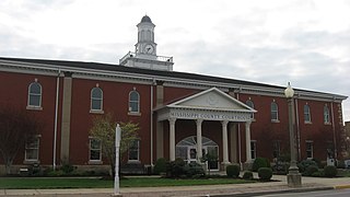
Mississippi County is a county located in the Bootheel of the U.S. state of Missouri, with its eastern border formed by the Mississippi River. As of the 2010 census, the population was 14,358. The largest city and county seat is Charleston. The county was officially organized on February 14, 1845, and was named after the Mississippi River.

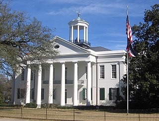
Warren County is a county located in the U.S. state of Mississippi. As of the 2010 census, the population was 48,773. Its county seat is Vicksburg. Created by legislative act of 22 December 1809, Warren County is named for American Revolutionary War officer Joseph Warren.

Issaquena County is a county located in the U.S. state of Mississippi. As of the 2010 census, the population was 1,406, making it the least populous county in the United States east of the Mississippi River. Its county seat is Mayersville. With a per-capita income of $18,598, Issaquena County is the poorest county in the United States.
Hinds County is a county located in the U.S. state of Mississippi. As of the 2010 census, the population was 245,285, making it the most populous county in Mississippi. Its county seats are Raymond and Jackson, the state capital. The county is named for General Thomas Hinds, a hero of the Battle of New Orleans during the War of 1812.

Bradley County is a county located in the U.S. state of Arkansas. As of the 2010 census, the population was 11,508. The county seat is Warren. It is Arkansas's 43rd county, formed on December 18, 1840, and named for Captain Hugh Bradley, who fought in the War of 1812. It is an alcohol prohibition or dry county, and is the home of the Bradley County Pink Tomato Festival.
Scouting in Mississippi has a long history, from the 1910s to the present day, serving thousands of youth in programs that suit the environment in which they live.
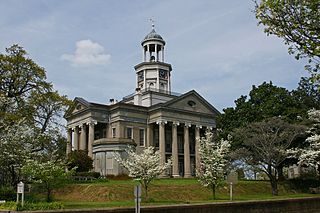
Vicksburg is a city in Warren County, Mississippi, United States. It is the county seat, and the population at the 2010 census was 23,856.

The Mississippi Delta, also known as the Yazoo-Mississippi Delta, is the distinctive northwest section of the U.S. state of Mississippi which lies between the Mississippi and Yazoo Rivers. The region has been called "The Most Southern Place on Earth", because of its unique racial, cultural, and economic history. It is 200 miles (320 km) long and 87 miles (140 km) across at its widest point, encompassing about 4,415,000 acres (17,870 km2), or, almost 7,000 square miles of alluvial floodplain. Originally covered in hardwood forest across the bottomlands, it was developed as one of the richest cotton-growing areas in the nation before the American Civil War (1861–1865). The region attracted many speculators who developed land along the riverfronts for cotton plantations; they became wealthy planters dependent on the labor of black slaves, who composed the vast majority of the population in these counties well before the Civil War, often twice the number of whites.

The Driftless Area is a region in southwestern Wisconsin, southeastern Minnesota, northeastern Iowa, and the extreme northwestern corner of Illinois, of the American Midwest. The region escaped the flattening effects of glaciation during the last ice age and is consequently characterized by steep, forested ridges, deeply carved river valleys, and karst geology characterized by spring-fed waterfalls and cold-water trout streams. Ecologically, the Driftless Area's flora and fauna are more closely related to those of the Great Lakes region and New England than those of the broader Midwest and central Plains regions. Colloquially, the term includes the incised Paleozoic Plateau of southeastern Minnesota and northeastern Iowa. The region includes elevations ranging from 603 to 1,719 feet at Blue Mound State Park and covers 24,000 square miles (62,200 km2). The rugged terrain is due both to the lack of glacial deposits, or drift, and to the incision of the upper Mississippi River and its tributaries into bedrock.

The Golden Triangle (GTR) is a region in the east central portion of the U.S. state of Mississippi. The "triangle" is formed by the cities of Columbus, Starkville, and West Point but the region is often more broadly-defined to include all of Clay, Lowndes, and Oktibbeha counties and sometimes additional surrounding communities and counties as well. The term was created as a marketing strategy in the 1990s to promote economic development in the region and encourage additional cooperation between local communities in attracting investment.

Homochitto National Forest is a U.S. National Forest in southwestern Mississippi comprising 191,839 acres (776.34 km2). In the mid-1930s, the Civilian Conservation Corps (CCC) began reforestation of the area and developing a system of roadways and recreational areas.

East Mississippi Community College (EMCC), formerly known as East Mississippi Junior College, is a public community college in Scooba, Mississippi. EMCC serves and is supported by Clay, Kemper, Lauderdale, Lowndes, Noxubee and Oktibbeha counties in east central Mississippi. The college has two principal campuses in Scooba and Mayhew, Mississippi and offers courses at five other locations. One of fifteen community colleges in Mississippi, EMCC is accredited by the Southern Association of Colleges and Schools Commission on Colleges (SACSCOC) to award the Associate of Applied Science degree and the Associate of Arts degree.

Walls is a town located in northern DeSoto County, Mississippi, United States, near the Mississippi River, part of the larger region known as "The Delta", and known for its rich, dark soil. As it is in the upper northwest corner of Mississippi, it is in the Memphis, Tennessee metropolitan area. Its ZIP code is 38680. As of the 2010 census it had a population of 1,162, with an estimated population of 1,463 in 2018.

Saginaw is an unincorporated area in Saint Louis County, Minnesota, United States. Although unincorporated, Saginaw has a post office with the ZIP code 55779.

Warrenton is an unincorporated community in Warren County, Mississippi. It is located approximately 5 miles south of Vicksburg on U.S. Route 61.

Brandon is a city in Rankin County, Mississippi, United States. Brandon was incorporated December 19, 1831. The population was 21,705 at the 2010 census. It is the county seat of Rankin County. Brandon is part of the Jackson Metropolitan Statistical Area, and is located east of the state capital.

Purdis Farm is a civil parish, in the East Suffolk district, in the English county of Suffolk. It is located on the eastern edge of Ipswich and includes areas of suburban housing and industrial development along the A1156, including the area of Warren Heath. In 2001 the population of the area was 1743, the population increasing to 2,092 at the 2011 Census.
Purgatory Correctional Facility is the county jail of Washington County, Utah. Also known as the Washington County Jail, it is located near St. George, Utah, at Purgatory Flats, hence its unusual name.

Yokena is an unincorporated community in southern Warren County, Mississippi, United States. It is bordered to the south by the Big Black River, to the north by Warrenton, to the east by Campbell Swamp, and to the west by U.S. Highway 61.
The Glass Site is a Plaquemine culture archaeological site located approximately 9.5 kilometres (5.9 mi) south of Vicksburg in Warren County, Mississippi. Originally the site had four platform mounds surrounding a large open plaza, but land leveling for modern farming techniques and looting by pothunters mean only portions of three have survived into the 21st century. It was a major ceremonial center that was contemporaneous with other large Plaquemine sites including Emerald, Holly Bluff, and Winterville and whose main occupation period occurred during the protohistoric period from 1500 to 1650 CE. Parts of the site were excavated by Clarence Bloomfield Moore in 1910 and 1911, and by Lauren Elizabeth Downs in 2007-2009.


