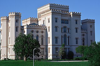
Baton Rouge is a city in and the capital of the U.S. state of Louisiana. Located the eastern bank of the Mississippi River, it is the parish seat of East Baton Rouge Parish, Louisiana's most populous parish—the equivalent of counties in other U.S. states. Since 2020, it has been the second-largest city in Louisiana after New Orleans; Baton Rouge is the 18th-most-populous state capital. According to the 2020 United States census, the city-proper had a population of 227,470; its consolidated population was 456,781 in 2020. The city is the center of the Greater Baton Rouge area—Louisiana's second-largest metropolitan area—with a population of 870,569 as of 2020, up from 802,484 in 2010.

Warren County is a county located in the U.S. state of Mississippi. As of the 2020 census, the population was 44,722. Its county seat is Vicksburg. Created by legislative act of December 22, 1809, Warren County is named for American Revolutionary War officer Joseph Warren.
St. John the Baptist Parish is a parish located in the U.S. state of Louisiana. At the 2020 census, the population was 42,477. The parish seat is Edgard, an unincorporated area, and the largest city is LaPlace, which is also unincorporated.
Eutaw is a city in and the county seat of Greene County, Alabama, United States. At the 2020 census, the population was 2,937. The city was named in honor of the Battle of Eutaw Springs, the last engagement of the American Revolutionary War in the Carolinas.

Batesville is the county seat and largest city of Independence County, Arkansas, United States, 80 miles (183 km) northeast of Little Rock, the state capital. According to the 2010 Census, the population of the city was 10,268. The city serves as a regional manufacturing and distribution hub for the Ozark Mountain region and Northeast Arkansas.

Pocahontas is a city in Randolph County, Arkansas, United States, along the Black River. According to the 2010 Census Bureau, the population of the city was 6,608. The city is the county seat of Randolph County.

Morganza is an incorporated village near the Mississippi River in Pointe Coupee Parish, Louisiana, United States. The population was 610 at the 2010 census, down from 659 in 2000. It is part of the Baton Rouge Metropolitan Statistical Area. The village's zip code is 70759. The Morganza Spillway, a flood control structure between the Mississippi River and the Atchafalaya Basin, is located nearby.

Glen Burnie is an unincorporated town and census-designated place (CDP) in Anne Arundel County, Maryland, United States. It is a suburb of Baltimore. The population of Glen Burnie was 67,639 at the 2010 census.

Wabasha is a city and the county seat of Wabasha County, Minnesota. The population was 2,559 at the time of the 2020 census. It is on the Mississippi River, near its confluence with the Zumbro River.

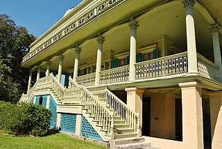
Natchez is the only city in and the county seat of Adams County, Mississippi, United States. It has a total population of 14,520. Located on the Mississippi River across from Vidalia in Concordia Parish, Louisiana, Natchez was a prominent city in the antebellum years, a center of cotton planters and Mississippi River trade.

Lexington is a city in and the county seat of Holmes County, Mississippi, United States. The county was organized in 1833 and the city in 1836. The population was 1,731 at the 2010 census, down from 2,025 at the 2000 census. The estimated population in 2018 was 1,496. It has declined from its high of 3,198 in 1950 due to the expansion of industrial-scale agriculture.

Aberdeen is the county seat of Monroe County, Mississippi, United States. As of the 2010 census, the population was 5,612.
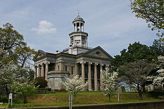
Vicksburg is a historic city in Warren County, Mississippi, United States. It is the county seat, and the population at the 2010 census was 23,856.

Barnwell is a city in and county seat of Barnwell County, South Carolina, United States, located along U.S. Route 278. The population was 4,750 at the 2010 census.

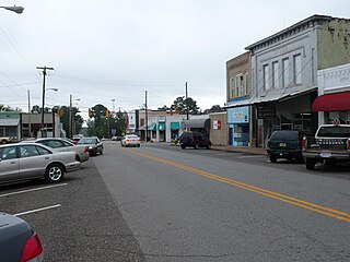
Sikeston is a city located both in southern Scott County and northern New Madrid County, in the state of Missouri, United States. It is situated just north of the "Missouri Bootheel", although many locals consider Sikeston a part of it. By way of Interstate 55, Interstate 57, and U.S. Route 60, Sikeston is close to the halfway point between St. Louis and Memphis, Tennessee and is three hours from Nashville.

Clarksville is an unincorporated community in Howard County, Maryland; the second highest-earning county in the United States according to the U.S. Census Bureau. The community is named for William Clark, a farmer who owned much of the land on which the community now lies and served as a postal stop that opened on the 4th of July 1851.

Southeast Texas is a cultural and geographic region in the U.S. state of Texas, bordering Southwest Louisiana and its greater Acadiana region to the east. Being a part of East Texas, the region is geographically centered on the Greater Houston and Beaumont–Port Arthur metropolitan statistical areas with a combined population of 7,662,325 according to the 2020 U.S. census.

Northeast Texas is a cultural and geographic region in the northeast corner of the U.S. state of Texas. Geographically centered on two metropolitan areas strung along Interstate 20—Tyler in the west and Longview/Marshall to the east, the areas of Mount Pleasant, Sulphur Springs, Paris, and Texarkana in the north primarily along Interstate 30, and Jacksonville and Palestine to the south are also major cities within the region. Most of Northeast Texas is included in the interstate region of the Ark-La-Tex.

Suffolk is an independent city in the Commonwealth of Virginia, and as such has no county. As of the 2020 census, the population was 94,324. It is the 10th most populous city in Virginia and the largest city in Virginia by boundary land area as well as the 14th largest in the country.

Mississippi is a state in the Southeastern region of the United States, bordered to the north by Tennessee; to the east by Alabama; to the south by the Gulf of Mexico; to the southwest by Louisiana; and to the northwest by Arkansas. Mississippi's western boundary is largely defined by the Mississippi River. Mississippi is the 32nd largest and 35th-most populous of the 50 U.S. states and has the lowest per-capita income in the United States. Jackson is both the state's capital and largest city. Greater Jackson is the state's most populous metropolitan area, with a population of 591,978 in 2020.


