
Warren County is a county located in the U.S. state of Mississippi. Its western border is formed by the Mississippi River. As of the 2020 census, the population was 44,722. Its county seat is Vicksburg. Established by legislative act of December 22, 1809, Warren County is named for American Revolutionary War officer Joseph Warren.

Vicksburg is a historic city in Warren County, Mississippi, United States. It is the county seat. The population was 21,573 at the 2020 census. Located on a high bluff on the east bank of the Mississippi River across from Louisiana, Vicksburg was built by French colonists in 1719. The outpost withstood an attack from the native Natchez people. It was incorporated as Vicksburg in 1825 after Methodist missionary Newitt Vick. The area that is now Vicksburg was long occupied by the Natchez Native Americans as part of their historical territory along the Mississippi. The first Europeans who settled the area were French colonists who built Fort Saint Pierre in 1719 on the high bluffs overlooking the Yazoo River at present-day Redwood. They conducted fur trading with the Natchez and others, and started plantations. During the American Civil War, it was a key Confederate river-port, and its July 1863 surrender to Ulysses S. Grant, along with the concurrent Battle of Gettysburg, marked the turning-point of the war.

Spanish Lake is an unincorporated community and census-designated place (CDP) in St. Louis County, Missouri, United States. The population was 18,413 at the 2020 census.

Tunica Resorts, formerly known as Robinsonville until 2005, is a census-designated place (CDP) in northern Tunica County, Mississippi, United States, north of the county seat of Tunica. The community is situated mostly between the Mississippi River and U.S. Route 61, along the border with Arkansas. The population as of the 2020 census was 2,132.
Benton is a census-designated place and unincorporated community in Yazoo County, Mississippi. It was first named as a CDP in the 2020 Census which listed a population of 415.
Bovina is a census-designated place and unincorporated community located about 7 miles (11 km) east of Vicksburg in Warren County, Mississippi, on Interstate 20. It is part of the Vicksburg Micropolitan Statistical Area.
Eagle Bend is a census-designated place and unincorporated community in Warren County, Mississippi. It is approximately 31 miles northwest of downtown Vicksburg, and is part of the Vicksburg Micropolitan Statistical Area.

Lauderdale is an unincorporated community and census-designated place (CDP) in Lauderdale County, Mississippi, United States. The population of Lauderdale was 395 at the 2020 census. It is located along U.S. Highway 45, 16 miles (26 km) northeast of Meridian.

Triumph is an unincorporated community and census-designated place in Plaquemines Parish, Louisiana, United States. It is located on the south bank of the Mississippi River. As of the 2020 census, its population was 268.

Winterville is a census-designated place and unincorporated community located in Washington County, Mississippi, near Mississippi Highway 1. Winterville is approximately 3 miles (4.8 km) north of Greenville, the county seat, and approximately 4 miles (6.4 km) south of Lamont.
Eudora is a census-designated place and unincorporated community located in southwestern DeSoto County, Mississippi, United States, approximately 25 miles (40 km) south of Memphis, Tennessee. The intersection of Mississippi Highway 301 and old Mississippi Highway 304 has been the traditional heart of Eudora for decades.
Delta City is a census-designated place and unincorporated community located on Mississippi Highway 434 in Sharkey County, Mississippi. Delta City is approximately 6 miles (9.7 km) east of Panther Burn and approximately 5 miles (8.0 km) north of Nitta Yuma. Although an unincorporated community, Delta City has a zip code of 39061.

Rena Lara is a census-designated place and unincorporated community located along Mississippi Highway 1 in southwestern Coahoma County, Mississippi, United States. Rena Lara is located on the former Riverside Division of the Yazoo and Mississippi Valley Railroad. Rena Lara was once home to two general stores, two grocery stores, and the Richardson and May Land & Planting Company.
Ovett is a census-designated place and unincorporated community in southeastern Jones County, Mississippi. Ovett is part of the Laurel Micropolitan Statistical Area.
Darling is a census-designated place in Quitman County, Mississippi. Darling is located on Mississippi Highway 3, north of Marks. Per the 2020 Census, the population was 154.
Lamar is a census-designated place and unincorporated community in Benton County, Mississippi, United States. It is located along Mississippi Highway 7 in western Benton County. Lamar has a post office with the ZIP code 38642. The nearly abandoned Mississippi Central Railroad runs through Lamar, and is only used rarely for freight trafficking.
Van Vleet is a census-designated place and unincorporated community in Chickasaw County, Mississippi, United States. Van Vleet is located at the junction of Mississippi Highway 32 and Mississippi Highway 385, 8 miles (13 km) northeast of Houston. Van Vleet has a post office with ZIP code 38877.

White Oak is a census-designated place located on Mississippi Highway 4 in Tunica County, Mississippi. White Oak is approximately 2 miles (3.2 km) east of Evansville and approximately 8 miles (13 km) west of Savage. The population at the 2020 census was 692.
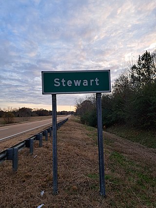
Stewart is a census-designated place and unincorporated community in Montgomery County, Mississippi, United States. As of the 2020 census, it had a population of 99.
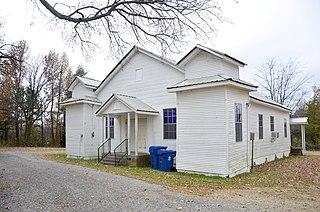
Beechwood is a census-designated place (CDP) in Warren County, Mississippi, United States. The population was 3,469 at the 2020 census.


